
Bestand:EFS highres STS091 STS091-731-32.JPG

Oorspronkelijk bestand (4.078 × 4.078 pixels, bestandsgrootte: 15,84 MB, MIME-type: image/jpeg)
| Dit is een bestand van Wikimedia Commons. Onderstaande beschrijving komt van de beschrijving van het bestand daar. |
Beschrijving
| Beschrijving |
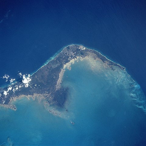
English: STS091-731-032 Grand Bahama Island, Freeport and Lucaya, Bahamas June 1998
The small cities of Freeport and Lucaya, on the southwest portion of Grand Bahama Island (slightly above the center of the view), can be seen in this southwest-looking view. Freeport and Lucaya are the Bahamas second largest metropolitan area. Nearly 50 years ago, neither city even existed. The Freeport and Lucaya region is a free trade zone area. Besides numerous tourist resorts and recreational areas, Freeport and Lucaya’s other activities include oil refining, cement production, distilling of liquor, and making of pharmaceutical products. As with the other islands of the Bahamas, Grand Bahama is composed largely of calcareous materials derived from marine organisms. A karst landscape covers many of the higher elevations on the island. Grand Bahama Island is 96 miles (154 km) long and 17 miles (27 km) at its widest point. The darker blue, deep waters of the Atlantic Ocean are visible in the upper portion of the view. The lighter blue, shallow waters covering the Bahama Shelf are discernible in the bottom portion of the view. Images: All Available Images Low-Resolution 277k Mission: STS091 Roll - Frame: 731 - 32 Geographical Name: BAHAMAS Features: FREEPORT, GRAND BAHAMA I. Center Lat x Lon: 26.5N x 78.5W Film Exposure: N N=Normal exposure, U=Under exposed, O=Over exposed, F=out of Focus Percentage of Cloud Cover-CLDP: 5 Camera: HB Camera Tilt: 16 LO=Low Oblique, HO=High Oblique, NV=Near Vertical Camera Focal Length: 250 Nadir to Photo Center Direction: NW The direction from the nadir to the center point, N=North, S=South, E=East, W=West Stereo?: Y Y=Yes there is an adjacent picture of the same area, N=No there isn't Orbit Number: 78 Date: 19980607 YYYYMMDD Time: 195254 GMT HHMMSS Nadir Lat: 25.8N Latitude of suborbital point of spacecraft Nadir Lon: 77.9W Longitude of suborbital point of spacecraft Sun Azimuth: 274 Clockwise angle in degrees from north to the sun measured at the nadir point Space Craft Altitude: 198 nautical miles Sun Elevation: 53 Angle in degrees between the horizon and the sun, measured at the nadir point Land Views: ISLAND, COAST Water Views: OCEAN Atmosphere Views: Man Made Views: URBAN AREA, AIRPORT City Views: FREEPORT |
| Datum | |
| Bron |
http://eol.jsc.nasa.gov/sseop/EFS/photoinfo.pl?PHOTO=STS091-731-32 http://eol.jsc.nasa.gov/scripts/sseop/LargeImageAccess.pl?directory=EFS/highres/STS091&filename=STS091-731-32.JPG&filesize=16606733 |
| Auteur | Image Science and Analysis Laboratory, NASA-Johnson Space Center |
Deze afbeelding of video is gecatalogiseerd door een van de centrums van de Verenigde Staten National Aeronautics and Space Administration (NASA)onder Foto ID: STS091-731-32.Deze banner zegt niets over de auteursrechten die van toepassing zijn. Een normale auteursrechten-tag is nodig. Zie Commons:Licensing voor meer informatie. Andere talen:
|
Licentie
| Dit bestand bevindt zich in het publiek domein, omdat het gemaakt is door de NASA. In de reproductierichtlijnen van de NASA staat dat "NASA-materiaal niet beschermd wordt door auteursrecht, tenzij anders vermeld". | ||
 |
Waarschuwingen:
|
Bestandsgeschiedenis
Klik op een datum/tijd om het bestand te zien zoals het destijds was.
| Datum/tijd | Miniatuur | Afmetingen | Gebruiker | Opmerking | |
|---|---|---|---|---|---|
| huidige versie | 14 apr 2011 10:26 | | 4.078 × 4.078 (15,84 MB) | Andkore | {{Information |Description ={{en|1=STS091-731-032 Grand Bahama Island, Freeport and Lucaya, Bahamas June 1998 The small cities of Freeport and Lucaya, on the southwest portion of Grand Bahama Island (slightly above the center of the view), can be seen |
Bestandsgebruik
Dit bestand wordt op de volgende pagina gebruikt:
Globaal bestandsgebruik
De volgende andere wiki's gebruiken dit bestand:
- Gebruikt op el.wikipedia.org
- Gebruikt op en.wikipedia.org
- Gebruikt op es.wikipedia.org
- Gebruikt op eu.wikipedia.org
- Gebruikt op fa.wikipedia.org
- Gebruikt op fo.wikipedia.org
- Gebruikt op fr.wikipedia.org
- Gebruikt op ja.wikipedia.org
- Gebruikt op ka.wikipedia.org
- Gebruikt op pt.wikipedia.org
- Gebruikt op sr.wikipedia.org
- Gebruikt op tr.wikipedia.org
- Gebruikt op zh.wikipedia.org