
Bestand:El-Qasr (XIII).jpg

Grootte van deze voorvertoning: 800 × 600 pixels. Andere resoluties: 320 × 240 pixels | 640 × 480 pixels | 1.024 × 768 pixels | 1.280 × 960 pixels | 2.560 × 1.920 pixels | 3.264 × 2.448 pixels.
Oorspronkelijk bestand (3.264 × 2.448 pixels, bestandsgrootte: 5,99 MB, MIME-type: image/jpeg)
| Dit is een bestand van Wikimedia Commons. Onderstaande beschrijving komt van de beschrijving van het bestand daar. |
.jpg)
Beschrijving
| Beschrijving |
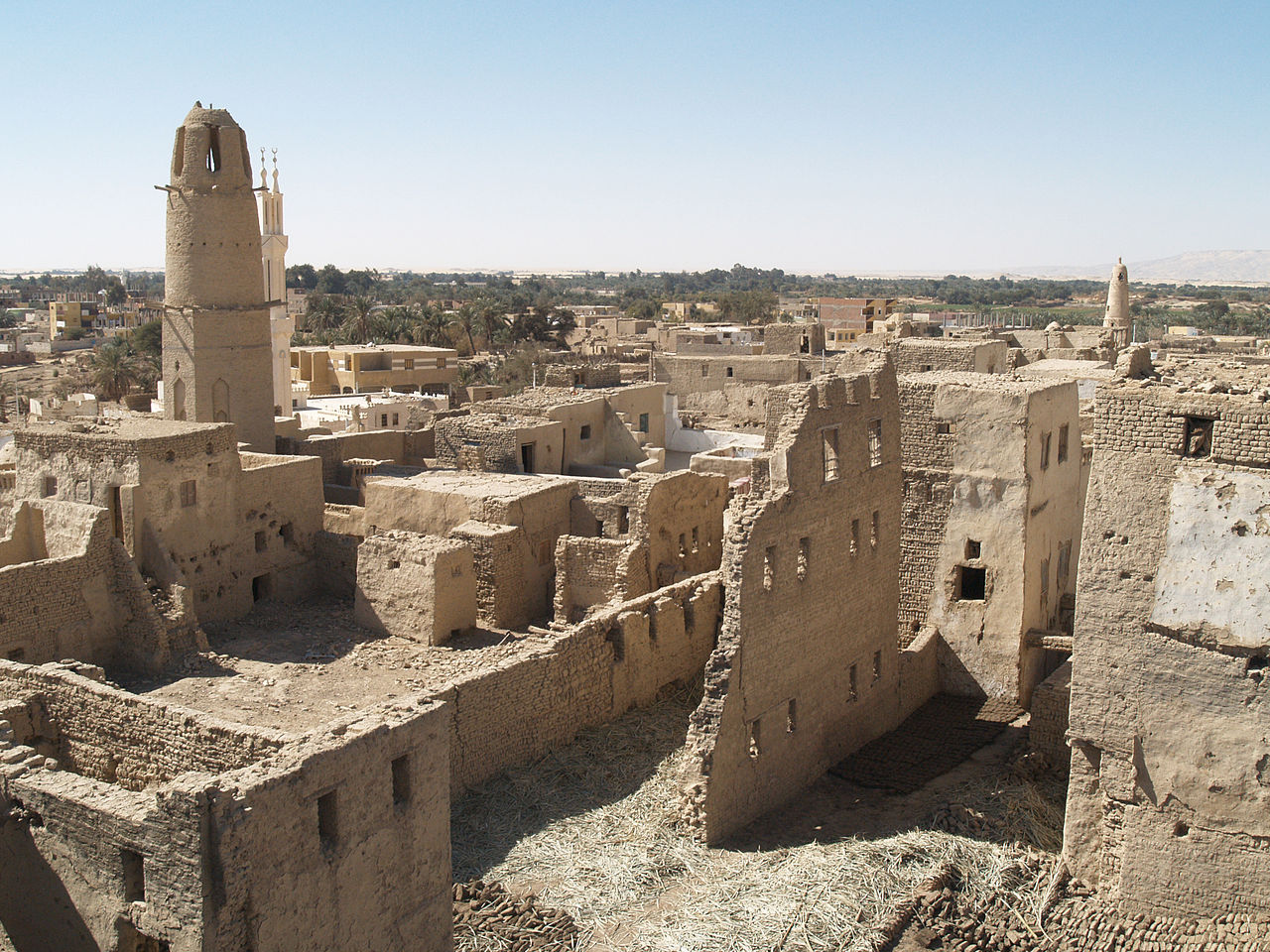
English: Al-Qasr is set at the foot of pink limestone cliffs on the northern rim of the oasis.
The architecture of the houses, which engulf the cool narrow streets and alleyways despite the summer heat and protect residents during sandstorms, attests to the importance the Ottomans placed in securing the remote oasis town. العربية: مدينة القصر الاثرية، منطقة اثار غرب الداخلة
مدينة القصر العثمانية العائدة الى العصور الوسطى. بُنيت هذه المدينة على أسس مدينة رومانية، تمّ تحديد موقعها عند سفح منحدرات من الحجر الجيري الوردي على الطرف الشمالي من الواحة. الشوارع والأزقة الضيقة فيها برودة على الرغم من حرارة الصيف وتحمي السكان من العواصف الرملية، والهندسة المعمارية للمنازل تشهد على الأهمية التي وضعها العثمانيون لجعل المدينة الموجودة في الواحة البعيدة أكثر أمنًا.
|
||
| Datum | |||
| Bron | https://www.flickr.com/photos/34561917@N04/4974052983/ | ||
| Auteur | isawnyu |
| Cameralocatie | | Deze en andere afbeeldingen in: OpenStreetMap |
|---|
.jpg¶ms=028.880674_N_0025.703207_E_globe:Earth_type:camera__&language=nl)
Licentie
| This image was originally posted to Flickr. Its license was verified as "cc-by-2.0" by the UploadWizard Extension at the time it was transferred to Commons. See the license information for further details. |
Dit bestand is gelicenseerd onder de Creative Commons-licentie Naamsvermelding 2.0 Unported
- De gebruiker mag:
- Delen – het werk kopiëren, verspreiden en doorgeven
- Remixen – afgeleide werken maken
- Onder de volgende voorwaarden:
- naamsvermelding – U moet op een gepaste manier aan naamsvermelding doen, een link naar de licentie geven, en aangeven of er wijzigingen in het werk zijn aangebracht. U mag dit op elke redelijke manier doen, maar niet zodanig dat de indruk wordt gewekt dat de licentiegever instemt met uw werk of uw gebruik van zijn werk.

|
Deze afbeelding werd geüpload als onderdeel van Wiki Loves Monuments 2014.
|
 |
Bestandsgeschiedenis
Klik op een datum/tijd om het bestand te zien zoals het destijds was.
| Datum/tijd | Miniatuur | Afmetingen | Gebruiker | Opmerking | |
|---|---|---|---|---|---|
| huidige versie | 27 sep 2014 01:03 | | 3.264 × 2.448 (5,99 MB) | Tarawneh | User created page with UploadWizard |
Bestandsgebruik
Dit bestand wordt op de volgende pagina gebruikt:
Globaal bestandsgebruik
De volgende andere wiki's gebruiken dit bestand:
- Gebruikt op ar.wikipedia.org
.jpg)