
Bestand:ElectoralCollege1984-Large.png
Grootte van deze voorvertoning: 800 × 430 pixels. Andere resoluties: 320 × 172 pixels | 640 × 344 pixels | 1.182 × 635 pixels.
Oorspronkelijk bestand (1.182 × 635 pixels, bestandsgrootte: 163 kB, MIME-type: image/png)
| Dit is een bestand van Wikimedia Commons. Onderstaande beschrijving komt van de beschrijving van het bestand daar. |
| U.S. presidential election maps from the National Atlas of the United States |
| See also: SVG maps |
| 1789 · 1792 · 1796 · 1800 · 1804 · 1808 · 1812 · 1816 · 1820 · 1824 · 1828 · 1832 · 1836 · 1840 · 1844 · 1848 · 1852 · 1856 · 1860 · 1864 · 1868 · 1872 · 1876 · 1880 · 1884 · 1888 · 1892 · 1896 · 1900 · 1904 · 1908 · 1912 · 1916 · 1920 · 1924 · 1928 · 1932 · 1936 · 1940 · 1944 · 1948 · 1952 · 1956 · 1960 · 1964 · 1968 · 1972 · 1976 · 1980 · 1984 · 1988 · 1992 · 1996 · 2000 · 2004 |
Beschrijving
| Beschrijving |
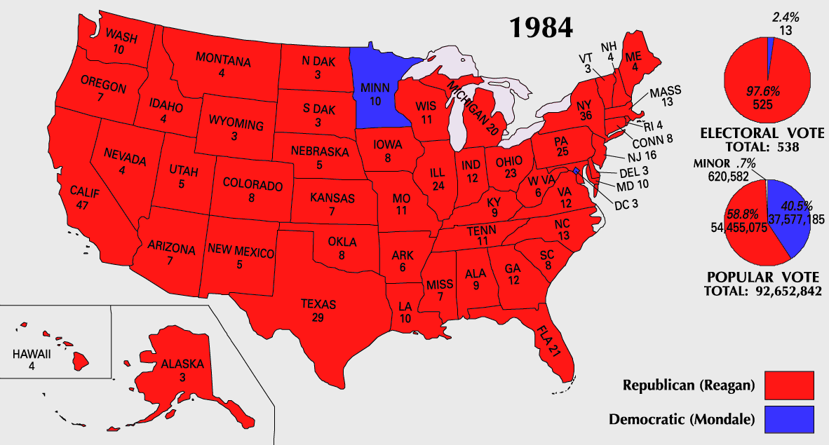
English: 1984 Electoral College Map |
|||
| Bron | https://nationalmap.gov/small_scale/printable/elections.html | |||
| Auteur | United States Geological Survey | |||
| Andere versies |
|


Licentie
This map was obtained from an edition of the National Atlas of the United States. Like almost all works of the U.S. federal government, works from the National Atlas are in the public domain in the United States.
Online access: NationalAtlas.gov | 1970 print edition: Library of Congress, Perry-Castañeda Library
|
Bestandsgeschiedenis
Klik op een datum/tijd om het bestand te zien zoals het destijds was.
| Datum/tijd | Miniatuur | Afmetingen | Gebruiker | Opmerking | |
|---|---|---|---|---|---|
| huidige versie | 25 jul 2007 12:20 | | 1.182 × 635 (163 kB) | Cardsplayer4life~commonswiki | Reverted to earlier revision |
| 25 jul 2007 11:32 |  | 1.182 × 635 (104 kB) | Joseph Solis in Australia~commonswiki | {{PD-USGov-Atlas}} Category:1988 {{US presidential election maps}} | |
| 9 jul 2007 03:46 |  | 1.182 × 635 (163 kB) | Cardsplayer4life~commonswiki | {{PD-USGov-Atlas}} Category:1984 {{US presidential election maps}} | |
| 6 jul 2007 11:36 |  | 1.182 × 635 (104 kB) | Joseph Solis in Australia~commonswiki | {{PD-USGov-Atlas}} Category:1984 {{US presidential election maps}} | |
| 2 jul 2007 04:28 |  | 1.182 × 635 (163 kB) | Cardsplayer4life~commonswiki | {{PD-USGov-Atlas}} Category:1984 {{US presidential election maps}} | |
| 29 jun 2007 12:14 |  | 1.182 × 635 (104 kB) | Joseph Solis in Australia~commonswiki | {{PD-USGov-Atlas}} Category:1984 {{US presidential election maps}} | |
| 21 jun 2007 23:07 |  | 1.182 × 635 (163 kB) | Cardsplayer4life~commonswiki | {{PD-USGov-Atlas}} Category:1984 {{US presidential election maps}} | |
| 31 mei 2007 10:27 |  | 1.182 × 635 (104 kB) | Joseph Solis in Australia~commonswiki | {{PD-USGov-Atlas}} Category:1984 {{US presidential election maps}} | |
| 25 mei 2006 22:06 |  | 1.182 × 635 (89 kB) | JP06035 | switched colors | |
| 22 jan 2006 18:08 |  | 1.182 × 635 (104 kB) | Red devil 666 | {{PD-USGov-Atlas}} |
Bestandsgebruik
Geen enkele pagina gebruikt dit bestand.
Globaal bestandsgebruik
De volgende andere wiki's gebruiken dit bestand:
- Gebruikt op hu.wikipedia.org