
Bestand:Faroe Islands-CIA WFB Map.png
Geen hogere resolutie beschikbaar.
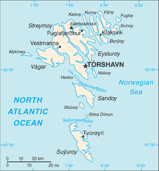
Faroe_Islands-CIA_WFB_Map.png (328 × 352 pixels, bestandsgrootte: 12 kB, MIME-type: image/png)
| Dit is een bestand van Wikimedia Commons. Onderstaande beschrijving komt van de beschrijving van het bestand daar. |
Deze afbeelding bevindt zich in het publiek domein omdat het materiaal bevat dat oorspronkelijk afkomstig is van het CIA World Factbook.
|
 |
Bestandsgeschiedenis
Klik op een datum/tijd om het bestand te zien zoals het destijds was.
| Datum/tijd | Miniatuur | Afmetingen | Gebruiker | Opmerking | |
|---|---|---|---|---|---|
| huidige versie | 30 jan 2006 10:19 | | 328 × 352 (12 kB) | Hoshie | Updated map of Faroe Islands from the CIA World Factbook, 10 Jan 06 rev.: http://www.cia.gov/cia/publications/factbook/maps/fo-map.gif |
| 27 mrt 2005 11:13 |  | 330 × 355 (8 kB) | Wolfman~commonswiki | {{CIA-map}} |
Bestandsgebruik
Dit bestand wordt op de volgende pagina gebruikt:
Globaal bestandsgebruik
De volgende andere wiki's gebruiken dit bestand:
- Gebruikt op be-tarask.wikipedia.org
- Gebruikt op be.wikipedia.org
- Gebruikt op en.wikipedia.org
- Gebruikt op en.wikisource.org
- Gebruikt op fo.wikipedia.org
- Gebruikt op gom.wikipedia.org
- Gebruikt op ml.wikipedia.org
- Gebruikt op pt.wikipedia.org