
Bestand:Free Territory of Trieste map.png

Grootte van deze voorvertoning: 379 × 599 pixels. Andere resoluties: 152 × 240 pixels | 505 × 798 pixels.
Oorspronkelijk bestand (505 × 798 pixels, bestandsgrootte: 131 kB, MIME-type: image/png)
| Dit is een bestand van Wikimedia Commons. Onderstaande beschrijving komt van de beschrijving van het bestand daar. |
Beschrijving
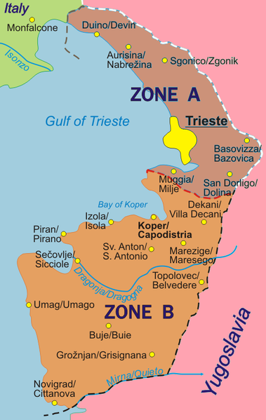
Map of the Free Territory of Trieste (1947-1954), with zone delimitation, in English. Own adaptation of http://sl.wikipedia.org/wiki/Slika:STO.png from the Slovene Wikipedia, by kind permission of the original author.
German version: Image:Freies_Territorium_Triest_Karte.png
Italian version: Image:Territorio_libero_di_Trieste_carta.png
Licentie
| Ik, de auteursrechthebbende van dit werk, geef dit werk vrij in het publieke domein. Dit is wereldwijd van toepassing. In sommige landen is dit wettelijk niet mogelijk; in die gevallen geldt: Ik sta iedereen toe dit werk voor eender welk doel te gebruiken, zonder enige voorwaarden, tenzij zulke voorwaarden door de wet worden voorgeschreven. |
Bestandsgeschiedenis
Klik op een datum/tijd om het bestand te zien zoals het destijds was.
| Datum/tijd | Miniatuur | Afmetingen | Gebruiker | Opmerking | |
|---|---|---|---|---|---|
| huidige versie | 21 mrt 2010 21:34 | | 505 × 798 (131 kB) | Ras67 | cropped |
| 6 okt 2007 03:32 |  | 511 × 804 (108 kB) | Tomchiukc | replace colours of map to distinguish land from the sea. | |
| 6 okt 2005 18:36 |  | 511 × 804 (122 kB) | Alib | Map of the Free Territory of Trieste (1947-1954), with zone delimitation, in English. Own adaptation of http://sl.wikipedia.org/wiki/Slika:STO.png from the Slovene Wikipedia, by kind permission of the original author. German version: [[Freies_Territorium_ |
Bestandsgebruik
Dit bestand wordt op de volgende pagina gebruikt:
Globaal bestandsgebruik
De volgende andere wiki's gebruiken dit bestand:
- Gebruikt op fi.wikipedia.org
- Gebruikt op hr.wikipedia.org
- Gebruikt op ja.wikipedia.org
- Gebruikt op sh.wikipedia.org
- Gebruikt op sv.wikipedia.org
- Gebruikt op tg.wikipedia.org