
Bestand:French Indochina locator.svg

Afmetingen van deze voorvertoning van het type PNG van dit SVG-bestand: 250 × 120 pixels Andere resoluties: 320 × 154 pixels | 640 × 307 pixels | 1.024 × 492 pixels | 1.280 × 614 pixels | 2.560 × 1.229 pixels.
Oorspronkelijk bestand (SVG-bestand, nominaal 250 × 120 pixels, bestandsgrootte: 166 kB)
| Dit is een bestand van Wikimedia Commons. Onderstaande beschrijving komt van de beschrijving van het bestand daar. |
Beschrijving
| Beschrijving |
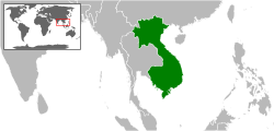
English: Location map of French Indochina
Deutsch: Lage von Französisch-Indochina |
|||
| Datum | ||||
| Bron | Eigen werk, based on BlankMap-World7.svg and BlankMap World simple.svg | |||
| Auteur |
|
|||
| Toestemming (Hergebruik van dit bestand) |
|
|||
| Andere versies |
|

Bestandsgeschiedenis
Klik op een datum/tijd om het bestand te zien zoals het destijds was.
| Datum/tijd | Miniatuur | Afmetingen | Gebruiker | Opmerking | |
|---|---|---|---|---|---|
| huidige versie | 5 mrt 2015 15:23 | | 250 × 120 (166 kB) | Master Uegly | {{Information |Description ={{en|1=Location map of French Indochina}} {{de|1=Lage von Französisch-Indochina}} |Source ={{own}}, based on BlankMap-World7.svg and [[:File:BlankMap World simple.svg|BlankMap World... |
Bestandsgebruik
Dit bestand wordt op de volgende 2 pagina's gebruikt:
Globaal bestandsgebruik
De volgende andere wiki's gebruiken dit bestand:
- Gebruikt op ast.wiktionary.org
- Gebruikt op azb.wikipedia.org
- Gebruikt op br.wikipedia.org
- Gebruikt op de.wikipedia.org
- Gebruikt op eo.wikipedia.org
- Gebruikt op eu.wikipedia.org
- Gebruikt op he.wikipedia.org
- Gebruikt op hr.wikipedia.org
- Gebruikt op jv.wikipedia.org
- Gebruikt op lt.wikipedia.org
- Gebruikt op pl.wikipedia.org
- Gebruikt op pl.wiktionary.org
- Gebruikt op pt.wikipedia.org
- Gebruikt op ro.wikipedia.org
- Gebruikt op simple.wikipedia.org
- Gebruikt op sk.wikipedia.org
- Gebruikt op tl.wikipedia.org
- Gebruikt op zh.wikipedia.org