
Bestand:Greenland ice sheet AMSL thickness map-en.svg

Afmetingen van deze voorvertoning van het type PNG van dit SVG-bestand: 352 × 599 pixels Andere resoluties: 141 × 240 pixels | 282 × 480 pixels | 451 × 768 pixels | 601 × 1.024 pixels | 1.202 × 2.048 pixels | 1.060 × 1.805 pixels.
Oorspronkelijk bestand (SVG-bestand, nominaal 1.060 × 1.805 pixels, bestandsgrootte: 2,19 MB)
| Dit is een bestand van Wikimedia Commons. Onderstaande beschrijving komt van de beschrijving van het bestand daar. |
Beschrijving
| Beschrijving |
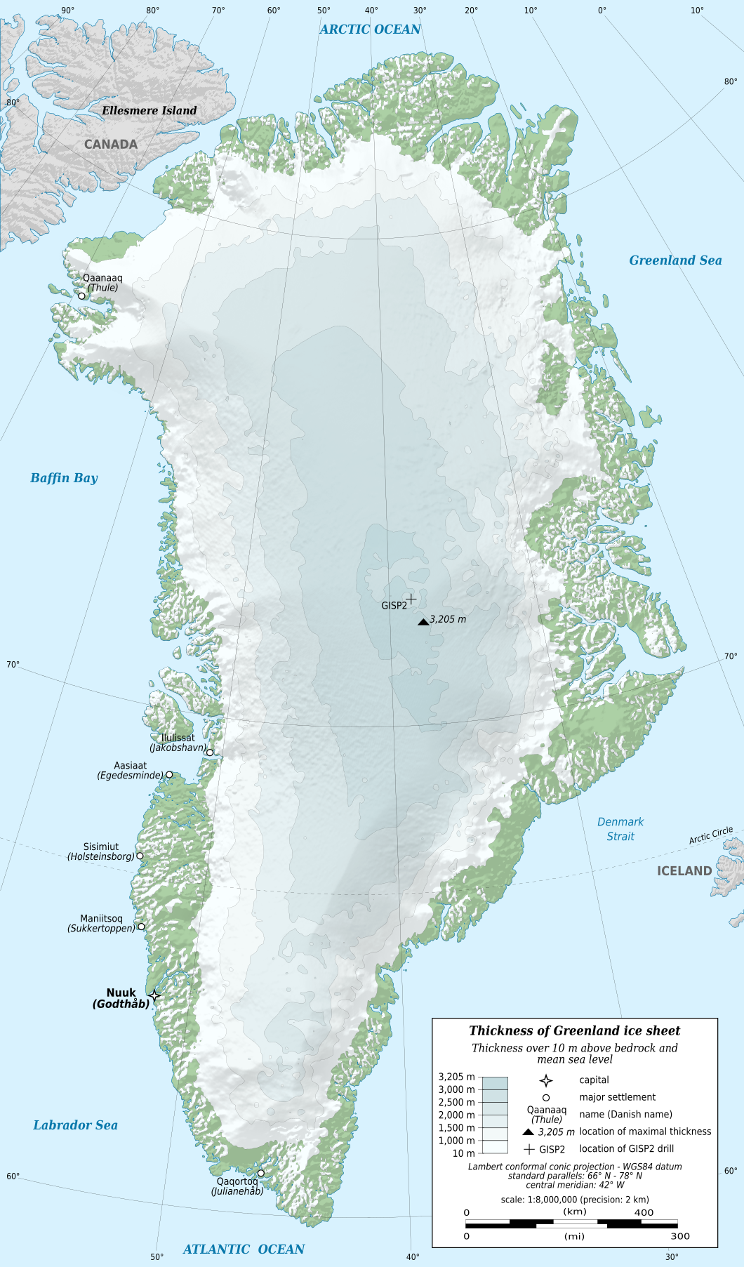
English: Map in English of Greenland ice sheet thickness. Thickness over 10 m above bedrock and mean sea level.
Note: the shaded relief is a raster image embedded in the SVG file. Français : Carte en anglais de l'épaisseur de l'inlandsis du Groenland. Épaisseur supérieure à 10 m au-dessus de la surface rocheuse et du niveau moyen des mers. Note : le relief ombré est une image bitmap embarquée dans le fichier SVG.
|
||
| Datum | |||
| Bron |
Eigen werk
|
||
| Auteur | Eric Gaba (Sting - fr:Sting) | ||
| Toestemming (Hergebruik van dit bestand) |
|
||
| Andere versies |
[]
|


| Cameralocatie | | Deze en andere afbeeldingen in: OpenStreetMap |
|---|

|
Dit SVG-bestand maakt gebruik van geïntegreerde tekst die gemakkelijk kan worden vertaald naar uw taal met een SVG editor, een tekstverwerker of het hulpmiddel SVG Translate. Uitleg |
Licentie
Eric Gaba (Wikimedia Commons user Sting), de auteursrechthebbende van dit werk, maakt het hierbij onder de volgende licentie beschikbaar:
Dit bestand is gelicenseerd onder de Creative Commons-licentie Naamsvermelding-Gelijk delen 3.0 Unported
Naamsvermelding: Eric Gaba (Wikimedia Commons user Sting)
- De gebruiker mag:
- Delen – het werk kopiëren, verspreiden en doorgeven
- Remixen – afgeleide werken maken
- Onder de volgende voorwaarden:
- naamsvermelding – U moet op een gepaste manier aan naamsvermelding doen, een link naar de licentie geven, en aangeven of er wijzigingen in het werk zijn aangebracht. U mag dit op elke redelijke manier doen, maar niet zodanig dat de indruk wordt gewekt dat de licentiegever instemt met uw werk of uw gebruik van zijn werk.
- Gelijk delen – Als u het werk heeft geremixt, veranderd, of erop heeft voortgebouwd, moet u het gewijzigde materiaal verspreiden onder dezelfde licentie als het oorspronkelijke werk, of een daarmee compatibele licentie.
Bestandsgeschiedenis
Klik op een datum/tijd om het bestand te zien zoals het destijds was.
| Datum/tijd | Miniatuur | Afmetingen | Gebruiker | Opmerking | |
|---|---|---|---|---|---|
| huidige versie | 18 feb 2011 23:57 | | 1.060 × 1.805 (2,19 MB) | Ras67 | black frame removed |
| 3 jan 2011 20:53 |  | 1.060 × 1.805 (2,19 MB) | Sting | == {{int:filedesc}} == {{Information |Description={{en|Map in English of Greenland ice sheet thickness. Thickness over 10 m above bedrock and mean sea level.<br/> ''Note: the shaded relief is a raster image embedded in the SVG |
Bestandsgebruik
Dit bestand wordt op de volgende 2 pagina's gebruikt:
Globaal bestandsgebruik
De volgende andere wiki's gebruiken dit bestand:
- Gebruikt op af.wikipedia.org
- Gebruikt op da.wikipedia.org
- Gebruikt op eu.wikipedia.org
- Gebruikt op fa.wikipedia.org
- Gebruikt op hi.wikipedia.org
- Gebruikt op hr.wikipedia.org
- Gebruikt op hy.wikipedia.org
- Gebruikt op id.wikipedia.org
- Gebruikt op ja.wikipedia.org
- Gebruikt op nn.wikipedia.org
- Gebruikt op no.wikipedia.org
- Gebruikt op ro.wikipedia.org
- Gebruikt op ru.wikipedia.org
- Gebruikt op sv.wikipedia.org
- Gebruikt op ta.wikipedia.org