
Bestand:Karta ID Maluku isl.PNG
Geen hogere resolutie beschikbaar.
Karta_ID_Maluku_isl.PNG (348 × 348 pixels, bestandsgrootte: 4 kB, MIME-type: image/png)
| Dit is een bestand van Wikimedia Commons. Onderstaande beschrijving komt van de beschrijving van het bestand daar. |
Beschrijving
| Beschrijving |
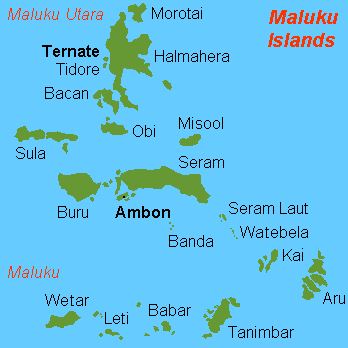
English: Map (rough) of Maluku islands, Indonesia, own work composed from various mapreferences |
| Datum | |
| Bron | Eigen werk |
| Auteur | Hobe / Holger Behr |
| Andere versies | Afgeleide werken van dit bestand: Maluku Islands international.png |
Licentie
| Ik, de auteursrechthebbende van dit werk, geef dit werk vrij in het publieke domein. Dit is wereldwijd van toepassing. In sommige landen is dit wettelijk niet mogelijk; in die gevallen geldt: Ik sta iedereen toe dit werk voor eender welk doel te gebruiken, zonder enige voorwaarden, tenzij zulke voorwaarden door de wet worden voorgeschreven. |
-
Bestandsgeschiedenis
Klik op een datum/tijd om het bestand te zien zoals het destijds was.
| Datum/tijd | Miniatuur | Afmetingen | Gebruiker | Opmerking | |
|---|---|---|---|---|---|
| huidige versie | 26 feb 2018 15:50 | | 348 × 348 (4 kB) | Sebastian Wallroth | Removed border by cropping 1 % horizontally and 1 % vertically using CropTool with precise mode. |
| 3 jul 2007 12:00 |  | 350 × 350 (7 kB) | Hobe | {{Information |Description=map Maluku islands, Indonesia |Source=self-made |Date=2007-07-01 |Author= Hobe Category:Maps of Indonesia }} | |
| 4 mei 2007 10:25 |  | 350 × 350 (7 kB) | Hobe | {{Information |Description=map Maluku islands, Indonesia, new version |Source=self made, composed from various mapreferences |Date=2007-05-04 |Author=Holger Behr }} | |
| 4 mei 2007 10:22 |  | 350 × 350 (7 kB) | Hobe | {{Information |Description=map Maluku islands, Indonesia, new version |Source=self-made, composed from various mapreferences |Date=2007-0425 |Author= User:Hobe }} | |
| 3 mei 2007 12:15 |  | 350 × 350 (7 kB) | Hobe | {{Information |Description=map Maluku islands, Indonesia |Source=own work, composed from various mapreferences |Date=2007-04-25 |Author=Holger Behr }} |
Bestandsgebruik
Dit bestand wordt op de volgende 2 pagina's gebruikt:
Globaal bestandsgebruik
De volgende andere wiki's gebruiken dit bestand:
- Gebruikt op als.wikipedia.org
- Gebruikt op ar.wikipedia.org
- Gebruikt op arz.wikipedia.org
- Gebruikt op az.wikipedia.org
- Gebruikt op bcl.wikipedia.org
- Gebruikt op be-tarask.wikipedia.org
- Gebruikt op be.wikipedia.org
- Gebruikt op ca.wikipedia.org
- Gebruikt op de.wikipedia.org
- Gebruikt op en.wikipedia.org
- Gebruikt op eo.wikipedia.org
- Gebruikt op es.wikipedia.org
- Gebruikt op eu.wikipedia.org
- Gebruikt op fa.wikipedia.org
- Gebruikt op fr.wikipedia.org
Globaal gebruik van dit bestand bekijken.