
Bestand:Karte Bahnstrecke Stralsund-Sassnitz.png
Grootte van deze voorvertoning: 800 × 596 pixels. Andere resoluties: 320 × 238 pixels | 640 × 477 pixels | 1.024 × 762 pixels | 1.280 × 953 pixels | 1.433 × 1.067 pixels.
Oorspronkelijk bestand (1.433 × 1.067 pixels, bestandsgrootte: 767 kB, MIME-type: image/png)
| Dit is een bestand van Wikimedia Commons. Onderstaande beschrijving komt van de beschrijving van het bestand daar. |
Beschrijving
| Beschrijving |
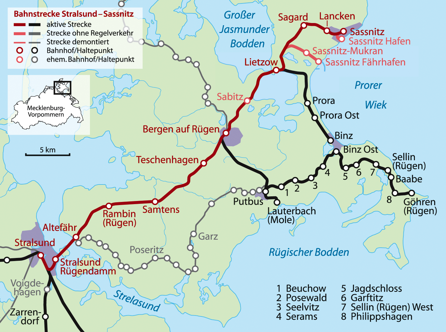
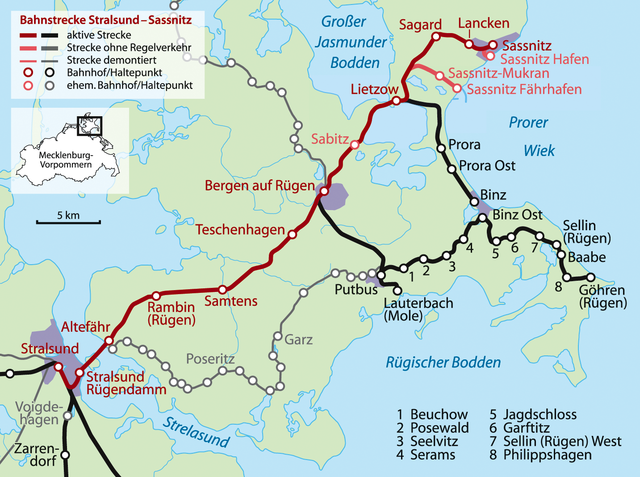
Deutsch: Karte der Bahnstrecke Stralsund–Sassnitz |
||
| Datum | |||
| Bron | Eigen werk | ||
| Auteur | NordNordWest | ||
| Andere versies |
|


|
Deze kaart is gemaakt of verbeterd in de Duitse Kartenwerkstatt (Map Lab). Je kunt ook zelf kaarten ter verbetering voorstellen.
|
Licentie
Ik, de auteursrechthebbende van dit werk, maak het hierbij onder de volgende licenties beschikbaar:

|
Toestemming wordt verleend voor het kopiëren, verspreiden en/of wijzigen van dit document onder de voorwaarden van de GNU-licentie voor vrije documentatie, versie 1.2 of enige latere versie als gepubliceerd door de Free Software Foundation; zonder Invariant Sections, zonder Front-Cover Texts, en zonder Back-Cover Texts. Een kopie van de licentie is opgenomen in de sectie GNU-licentie voor vrije documentatie. |
Dit bestand is gelicenseerd onder de Creative Commons-licentie Naamsvermelding-Gelijk delen 3.0 Unported
- De gebruiker mag:
- Delen – het werk kopiëren, verspreiden en doorgeven
- Remixen – afgeleide werken maken
- Onder de volgende voorwaarden:
- naamsvermelding – U moet op een gepaste manier aan naamsvermelding doen, een link naar de licentie geven, en aangeven of er wijzigingen in het werk zijn aangebracht. U mag dit op elke redelijke manier doen, maar niet zodanig dat de indruk wordt gewekt dat de licentiegever instemt met uw werk of uw gebruik van zijn werk.
- Gelijk delen – Als u het werk heeft geremixt, veranderd, of erop heeft voortgebouwd, moet u het gewijzigde materiaal verspreiden onder dezelfde licentie als het oorspronkelijke werk, of een daarmee compatibele licentie.
U mag zelf één van de licenties kiezen.
Bestandsgeschiedenis
Klik op een datum/tijd om het bestand te zien zoals het destijds was.
| Datum/tijd | Miniatuur | Afmetingen | Gebruiker | Opmerking | |
|---|---|---|---|---|---|
| huidige versie | 22 jan 2009 21:33 | | 1.433 × 1.067 (767 kB) | NordNordWest | {{Information |Description= |Source= |Date= |Author= |Permission= |other_versions= }} |
| 21 okt 2008 19:10 |  | 1.433 × 1.067 (762 kB) | NordNordWest | ||
| 20 okt 2008 22:28 |  | 1.433 × 1.067 (769 kB) | NordNordWest | {{Information |Description= {{de|Karte der Bahnstrecke Stralsund–Sassnitz}} |Source=own work |Date=20-10-2008 |Author= NordNordWest |Permission= |other_versions= }} {{Kartenwerkstatt}} [[Cat |
Bestandsgebruik
Dit bestand wordt op de volgende pagina gebruikt:
Globaal bestandsgebruik
De volgende andere wiki's gebruiken dit bestand:
- Gebruikt op de.wikipedia.org
- Gebruikt op en.wikipedia.org
- Gebruikt op it.wikipedia.org
- Gebruikt op mk.wikipedia.org
- Gebruikt op pl.wikipedia.org
- Gebruikt op www.wikidata.org