
Bestand:Karte der ÖPNV-Systeme in den USA.png
Grootte van deze voorvertoning: 800 × 491 pixels. Andere resoluties: 320 × 196 pixels | 640 × 393 pixels | 1.024 × 629 pixels | 1.280 × 786 pixels | 2.204 × 1.353 pixels.
Oorspronkelijk bestand (2.204 × 1.353 pixels, bestandsgrootte: 440 kB, MIME-type: image/png)
| Dit is een bestand van Wikimedia Commons. Onderstaande beschrijving komt van de beschrijving van het bestand daar. |
| Beschrijving |
|
| Datum | see file history |
| Bron | Eigen werk |
| Auteur | Maximilian Dörrbecker (Chumwa) |
| Toestemming (Hergebruik van dit bestand) |
Ik, de auteursrechthebbende van dit werk, maak het hierbij onder de volgende licentie beschikbaar: Dit bestand is gelicenseerd onder de Creative Commons-licentie Naamsvermelding-Gelijk delen 2.5 Unported
Sie dürfen das Bild zu den folgenden Bedingungen nutzen:
|
| Andere versies |
China
Czech Republic France
Germany
Italy
Japan
Korea Poland
Spain & Portugal
Turkey
British Isles Former Soviet Union
Balkans
North Africa
Latin America
United States of America
|


Bestandsgeschiedenis
Klik op een datum/tijd om het bestand te zien zoals het destijds was.
| Datum/tijd | Miniatuur | Afmetingen | Gebruiker | Opmerking | |
|---|---|---|---|---|---|
| huidige versie | 3 jun 2019 21:51 | | 2.204 × 1.353 (440 kB) | Chumwa | update |
| 30 jan 2018 21:04 |  | 2.204 × 1.353 (439 kB) | Chumwa | update | |
| 16 dec 2017 10:32 |  | 2.204 × 1.353 (438 kB) | Chumwa | +Milwaukee | |
| 10 dec 2014 12:22 |  | 2.204 × 1.353 (292 kB) | Kopiersperre | optipng | |
| 30 nov 2014 08:08 |  | 2.204 × 1.353 (443 kB) | Chumwa | correction: Nashville | |
| 28 nov 2014 07:40 |  | 2.204 × 1.353 (444 kB) | Chumwa | +Memphis | |
| 28 nov 2014 00:23 |  | 2.204 × 1.353 (443 kB) | Chumwa | update | |
| 30 mrt 2010 21:47 |  | 2.172 × 1.353 (407 kB) | Chumwa | commuter rails and some tramway systems added | |
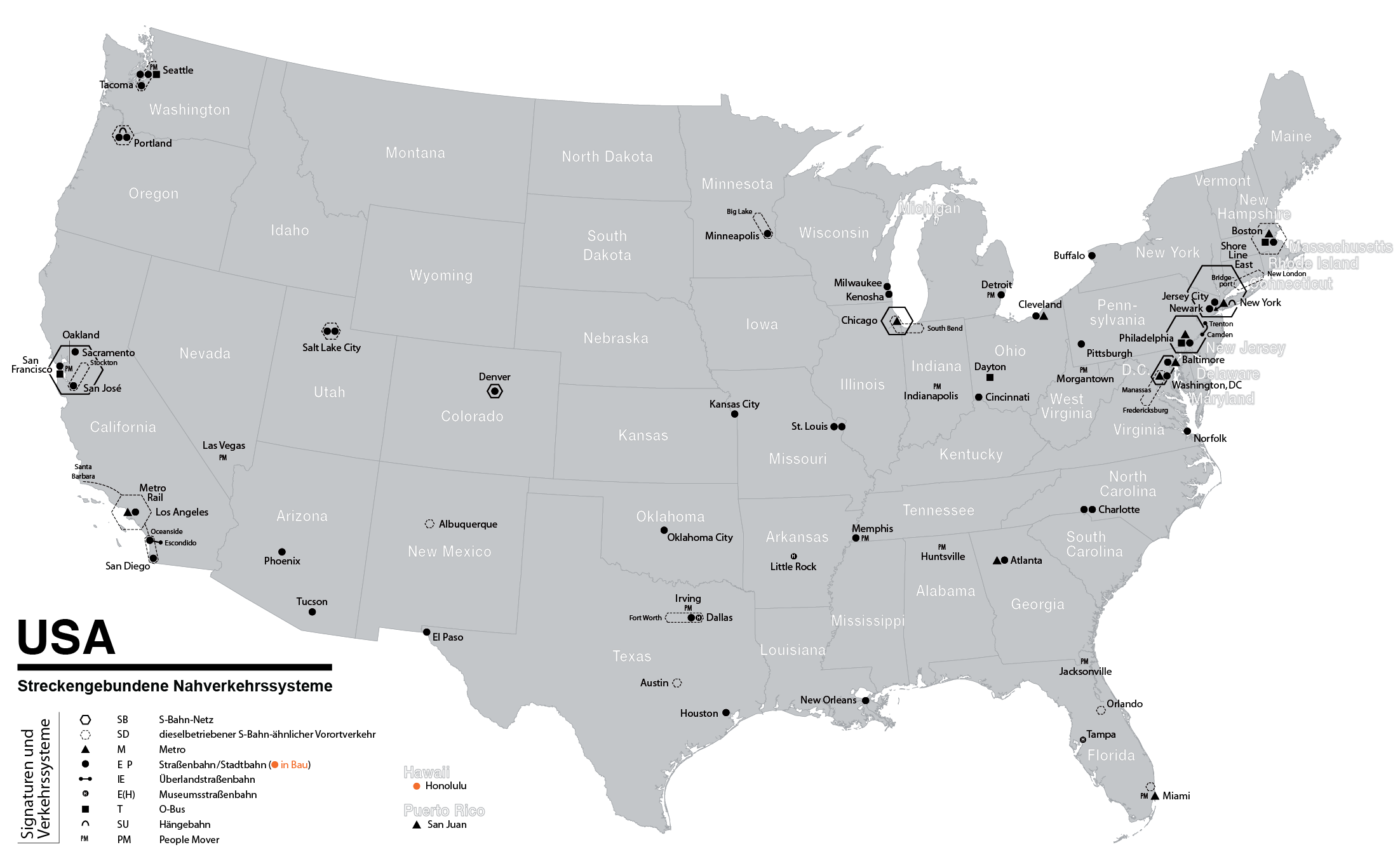
| 6 jun 2009 00:37 |  | 2.172 × 1.353 (384 kB) | Chumwa | {{Information |Description= *{{ de }} Karte der streckengebundenen Nahverkehrssysteme (S-Bahn, U-Bahn, Stadtbahn, Straßenbahn, O-Bus) in den USA (Stand: Juni 2009) *{{ en }} Map of fixed-route public transport systems (suburban railways, Rapid Transit an |
Bestandsgebruik
Dit bestand wordt op de volgende pagina gebruikt:
Globaal bestandsgebruik
De volgende andere wiki's gebruiken dit bestand:
- Gebruikt op cs.wikipedia.org
- Gebruikt op de.wikipedia.org
- Gebruikt op en.wikipedia.org
- Gebruikt op fr.wikipedia.org
- Gebruikt op ja.wikipedia.org
- Gebruikt op sk.wikipedia.org