
Bestand:Karte der Bahnstrecke Buchholz - Wittenberge.png
Grootte van deze voorvertoning: 800 × 215 pixels. Andere resoluties: 320 × 86 pixels | 640 × 172 pixels | 1.024 × 275 pixels | 3.400 × 914 pixels.
Oorspronkelijk bestand (3.400 × 914 pixels, bestandsgrootte: 859 kB, MIME-type: image/png)
| Dit is een bestand van Wikimedia Commons. Onderstaande beschrijving komt van de beschrijving van het bestand daar. |
Beschrijving
| Beschrijving |
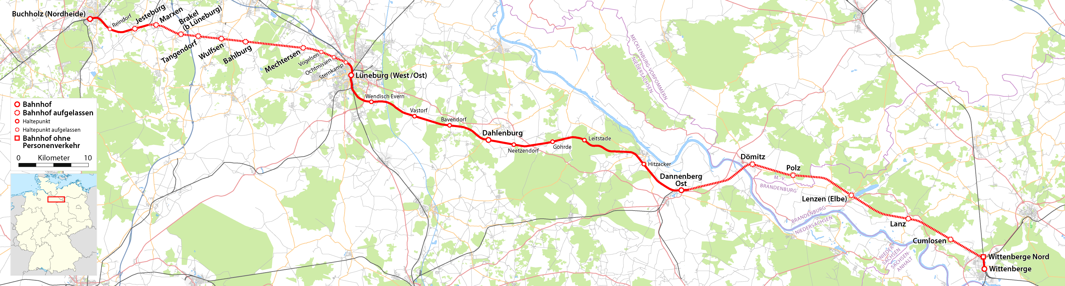
Deutsch: Karte der Bahnstrecke Buchholz-Wittenberge. |
| Datum | |
| Bron |
Own work using:
|
| Auteur | Maximilian Dörrbecker |
| Toestemming (Hergebruik van dit bestand) |
All OpenStreetMap data and maps are Creative Commons "CC-BY-SA 2.0" licensed Dit bestand is gelicenseerd onder de Creative Commons-licentie Naamsvermelding-Gelijk delen 2.0 Unported
|
-
 Gesamtbearbeitung
 -
 Buchholz - Hannover
 -
 Buchholz - Wittenberge
 -
 Amerikalinie
 -
 Langwedel - Uelzen
 -
 Uelzen - Braunschweig
 -
 Uelzen - Stendal
 -
 Uelzen - Dannenberg
 -
 Dannenberg - Salzwedel


}}
Bestandsgeschiedenis
Klik op een datum/tijd om het bestand te zien zoals het destijds was.
| Datum/tijd | Miniatuur | Afmetingen | Gebruiker | Opmerking | |
|---|---|---|---|---|---|
| huidige versie | 8 aug 2009 16:21 | 3.400 × 914 (859 kB) | Chumwa | Ländergrenzen hinzugefügt | |
| 2 aug 2009 16:49 | 3.400 × 914 (822 kB) | Chumwa | {{Information |Description={{de|Karte der Bahnstrecke Buchholz - Wittenberge.png}} |Author=Maximilian Dörrbecker (Chumwa) |Source={own}, using * OpenStreetMap data for the background * [[:File:Germany_location_ |
Bestandsgebruik
Dit bestand wordt op de volgende 2 pagina's gebruikt:
Globaal bestandsgebruik
De volgende andere wiki's gebruiken dit bestand:
- Gebruikt op de.wikipedia.org
- Gebruikt op en.wikipedia.org
- Gebruikt op www.wikidata.org