
Bestand:Khanate of Baku in the Map of Caucasus with the borders.jpg

Oorspronkelijk bestand (3.000 × 3.819 pixels, bestandsgrootte: 3,26 MB, MIME-type: image/jpeg)
| Dit is een bestand van Wikimedia Commons. Onderstaande beschrijving komt van de beschrijving van het bestand daar. |
| Beschrijving |
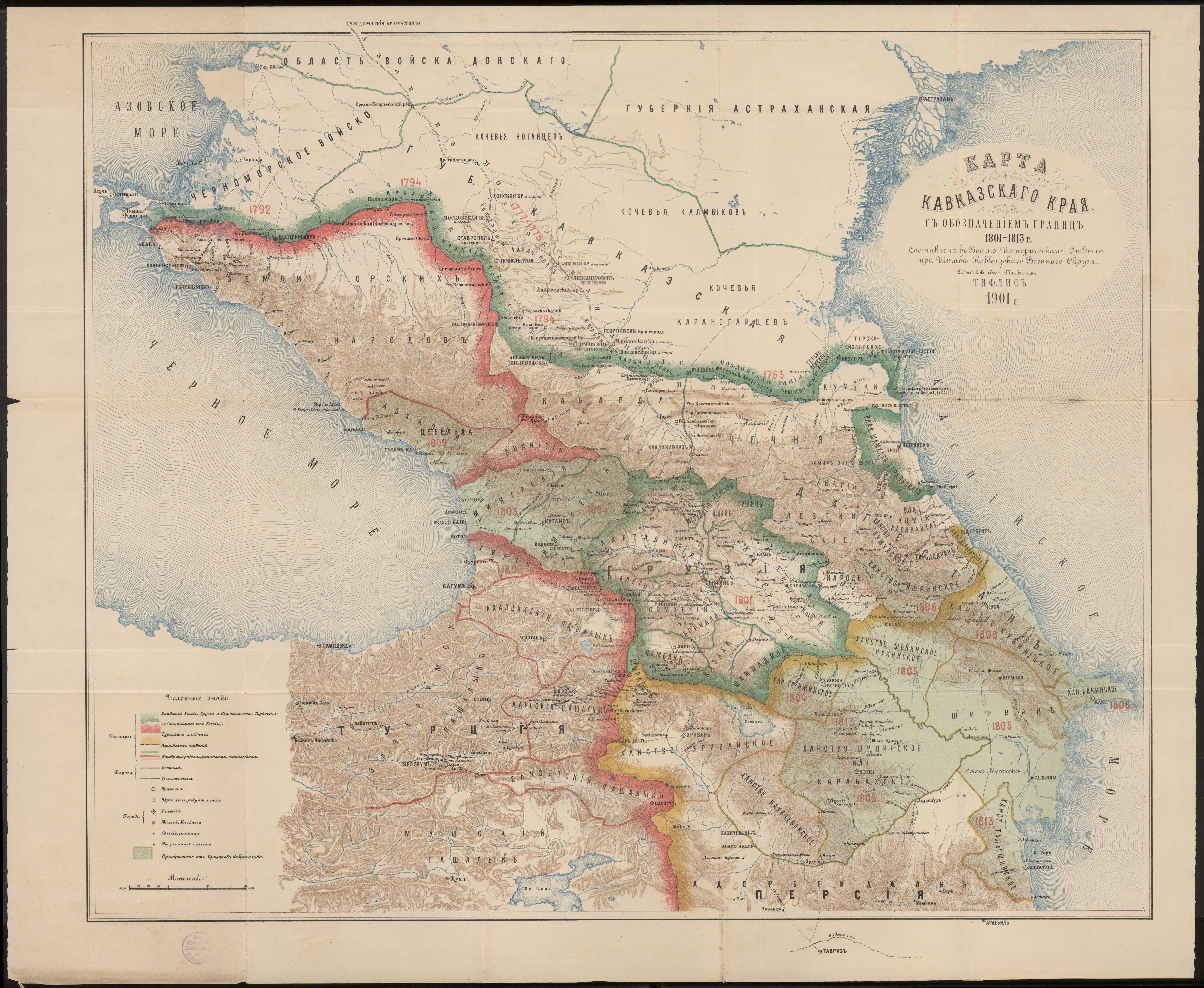
English: Khanate of Baku in the Map of Caucasus with the borders. |
| Datum | |
| Bron | Карта Кавказского края с обозначением границ 1801-1813 г. Составлена в военно-историческом отделе при штабе Кавказского военного округа подполковником Томкиевым. Тифлис 1901 г. |
| Auteur | Владимир Ильич Томкеев |
Dit werk bevindt zich in het publiek domein in Rusland volgens artikel 1256 van het Burgerlijk Wetboek van de Russische Federatie.
Dit werk werd gepubliceerd op het territorium van het Russische Rijk (Russische Republiek) uitgezonderd de gebieden van de Grootvorstendom Finland (Великое княжество Финляндское) en Congres-Polen (Царство Польское) voor 7 november 1917 en werd niet heruitgegeven in de 30 dagen na de eerste publicaties op het grondgebied van Sovjet-Rusland of andere landen. Rusland (voorheen Russische Socialistische Federatieve Sovjetrepubliek) is de historische erfgenaam maar niet de rechtsopvolger van het Russische Rijk.[1][2]
Gebruik indien mogelijk {{PD-Russia-expired}} in plaats van dit sjabloon. Dit werk bevindt zich in het publiek domein in de Verenigde Staten omdat het gepubliceerd werd (of geregistreerd bij de U.S. Copyright Office) voor 1 januari 1929. |
 |
Bestandsgeschiedenis
Klik op een datum/tijd om het bestand te zien zoals het destijds was.
| Datum/tijd | Miniatuur | Afmetingen | Gebruiker | Opmerking | |
|---|---|---|---|---|---|
| huidige versie | 1 mei 2020 22:14 | | 3.000 × 3.819 (3,26 MB) | Sword313 | Uploaded a work by Владимир Ильич Томкеев from [http://xn--b1aaibpv0aet4h1a.xn--p1ai/forums/uploads/gallery/album_19/gallery_4_19_4287845.jpg Карта Кавказского края с обозначением границ 1801-1813 г. Составлена в военно-историческом отделе при штабе Кавказского военного округа подполковником Томкиевым. Тифлис 1901 г.] with UploadWizard |
Bestandsgebruik
Geen enkele pagina gebruikt dit bestand.
Globaal bestandsgebruik
De volgende andere wiki's gebruiken dit bestand:
- Gebruikt op ca.wikipedia.org
- Gebruikt op fa.wikipedia.org
- Gebruikt op fr.wikipedia.org
- Gebruikt op hy.wikipedia.org
- Gebruikt op it.wikipedia.org
- Gebruikt op pt.wikipedia.org
- Gebruikt op ru.wikipedia.org
- Gebruikt op tr.wikipedia.org
- Gebruikt op uk.wikipedia.org
- Gebruikt op www.wikidata.org