
Bestand:Lage des Saale-Orla-Kreises in Deutschland.png
Geen hogere resolutie beschikbaar.
Lage_des_Saale-Orla-Kreises_in_Deutschland.png (197 × 235 pixels, bestandsgrootte: 2 kB, MIME-type: image/png)
| Dit is een bestand van Wikimedia Commons. Onderstaande beschrijving komt van de beschrijving van het bestand daar. |
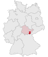
| Beschrijving | Saale-Orla-Kreis, Thuringia, Germany | ||||||||
| Datum | |||||||||
| Bron | Eigen werk | ||||||||
| Auteur | own work by Geograv | ||||||||
| Toestemming (Hergebruik van dit bestand) |
|

Bestandsgeschiedenis
Klik op een datum/tijd om het bestand te zien zoals het destijds was.
| Datum/tijd | Miniatuur | Afmetingen | Gebruiker | Opmerking | |
|---|---|---|---|---|---|
| huidige versie | 11 okt 2007 20:17 | | 197 × 235 (2 kB) | Rauenstein | {{Information |Description=Saale-Orla-Kreis, Thuringia, Germany |Source=self |Date=2007-10-11 |Author=own work by Geograv |Permission= {{GFDL}} }} [[Category:Locator maps of districts in Thuringia|Saale-O |
Bestandsgebruik
Geen enkele pagina gebruikt dit bestand.
Globaal bestandsgebruik
De volgende andere wiki's gebruiken dit bestand:
- Gebruikt op bg.wikipedia.org
- Gebruikt op eo.wikipedia.org
- Gebruikt op es.wikipedia.org
- Gebruikt op fr.wikipedia.org
- Gebruikt op ka.wikipedia.org
- Gebruikt op kk.wikipedia.org
- Gebruikt op la.wikipedia.org
- Gebruikt op pl.wikipedia.org
- Gebruikt op pt.wikipedia.org
- Gebruikt op sv.wikipedia.org