
Bestand:Map-of-southeast-asia 1300 CE.png
Grootte van deze voorvertoning: 426 × 599 pixels. Andere resoluties: 171 × 240 pixels | 341 × 480 pixels.
Oorspronkelijk bestand (800 × 1.125 pixels, bestandsgrootte: 251 kB, MIME-type: image/png)
| Dit is een bestand van Wikimedia Commons. Onderstaande beschrijving komt van de beschrijving van het bestand daar. |

|
Deze kaartafbeelding zou opnieuw moeten worden aangemaakt als een SVG-bestand door vectorafbeeldingen te gebruiken. Dit heeft een aantal voordelen; zie Commons:Media for cleanup voor meer informatie. Als er een SVG-formaat van deze afbeelding bestaat, dan deze graag uploaden. Nadat u dit heeft gedaan, gelieve dit sjabloon te vervangen door het sjabloon {{vector version available|nieuwe bestandsnaam.svg}} op deze afbeeldingspagina.
|
Beschrijving
| Beschrijving |
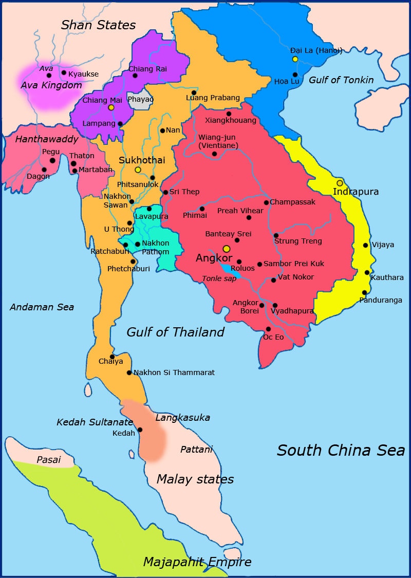
English: Map of Southeast Asia circa 1300 CE, showing Khmer Empire in red, Lavo kingdom/Dvaravati in light blue, Sukhothai empire in orange, Champa in yellow, Dai Viet in blue, Kingdom of Lanna in purple and surrounding states. |
| Datum | |
| Bron |
http://ecaimaps.berkeley.edu/animations/2003_03_khmer_animation.swf http://www.britannica.com/EBchecked/media/3395/Khmer-empire-1200 Atlas of world history, Patrick Karl O'brien. Societies, Networks, and Transitions: A Global History, Volume B. Craig A.Lockard http://upload.wikimedia.org/wikipedia/commons/thumb/4/45/Srivijaya_Empire.svg/2000px-Srivijaya_Empire.svg.png File:DvaravatiMapThailand.png http://upload.wikimedia.org/wikipedia/commons/e/eb/Thailand_2002_CIA_map.jpg |
| Auteur | Javierfv1212 |
| Andere versies |

Licentie
Ik, de auteursrechthebbende van dit werk, maak het hierbij onder de volgende licentie beschikbaar:
| Dit bestand is beschikbaar onder Creative Commons CC0 1.0 Universele Public Domain Dedication. | |
| De persoon die een werk voorziet van deze licentie stelt dit werk beschikbaar aan het publieke domein door, voor zover dit wettelijk is toegestaan, afstand te doen van alle rechten op het werk in de zin van het auteursrecht, met inbegrip van alle aanverwante of naburige rechten. U kunt het werk kopiëren, aanpassen, distribueren en uitvoeren, ook voor commerciële doeleinden, zonder dat u daarvoor toestemming hoeft te vragen.
|
Bestandsgeschiedenis
Klik op een datum/tijd om het bestand te zien zoals het destijds was.
| Datum/tijd | Miniatuur | Afmetingen | Gebruiker | Opmerking | |
|---|---|---|---|---|---|
| huidige versie | 28 mrt 2011 04:23 | | 800 × 1.125 (251 kB) | Javierfv1212 | {{Information |Description ={{en|1=Map of Southeast Asia circa 1300 CE, showing Khmer Empire in red, Lavo kingdom/Dvaravati in light blue, Sukhothai empire in orange, Champa in yellow, Kingdom of Lanna in purple and surrounding states. sources http: |
Bestandsgebruik
Dit bestand wordt op de volgende 4 pagina's gebruikt:
Globaal bestandsgebruik
De volgende andere wiki's gebruiken dit bestand:
- Gebruikt op ar.wikipedia.org
- Gebruikt op ast.wikipedia.org
- Gebruikt op es.wikipedia.org
- Gebruikt op fi.wikipedia.org
- Gebruikt op fr.wikipedia.org
- Gebruikt op id.wikipedia.org
- Gebruikt op is.wikipedia.org
- Gebruikt op it.wikipedia.org
- Gebruikt op ja.wikipedia.org
- Gebruikt op ka.wikipedia.org
- Gebruikt op km.wikipedia.org
- Gebruikt op ko.wikipedia.org
- Gebruikt op lo.wikipedia.org
- Gebruikt op ms.wikipedia.org
- Gebruikt op my.wikipedia.org
- Gebruikt op no.wikipedia.org
- Gebruikt op pt.wikipedia.org
- Gebruikt op sa.wikipedia.org
- Gebruikt op ta.wikipedia.org
- Gebruikt op th.wikipedia.org
- Gebruikt op tr.wikipedia.org
- Gebruikt op uk.wikipedia.org
- Gebruikt op www.wikidata.org