
Bestand:Map-position-klaksvikar-kommuna-2008.png

Grootte van deze voorvertoning: 450 × 600 pixels. Andere resoluties: 180 × 240 pixels | 600 × 800 pixels.
Oorspronkelijk bestand (600 × 800 pixels, bestandsgrootte: 32 kB, MIME-type: image/png)
| Dit is een bestand van Wikimedia Commons. Onderstaande beschrijving komt van de beschrijving van het bestand daar. |
Beschrijving
| Beschrijving |
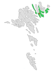
English: Map of the municipality of Klaksvík in the Faroe Islands, updated with the merger between the municipalities of Klaksvík and Svínoy in November 2008.
Norsk bokmål: Kart over kommunen Klaksvík på Færøyene, oppdatert med sammenslåingen mellom kommunene Klaksvík og Svínoy i november 2008. |
| Datum | |
| Bron | Eigen werk |
| Auteur | Erik Fløan |
| Andere versies |
 |
Licentie
Ik, de auteursrechthebbende van dit werk, maak het hierbij onder de volgende licenties beschikbaar:

|
Toestemming wordt verleend voor het kopiëren, verspreiden en/of wijzigen van dit document onder de voorwaarden van de GNU-licentie voor vrije documentatie, versie 1.2 of enige latere versie als gepubliceerd door de Free Software Foundation; zonder Invariant Sections, zonder Front-Cover Texts, en zonder Back-Cover Texts. Een kopie van de licentie is opgenomen in de sectie GNU-licentie voor vrije documentatie. |
Dit bestand is gelicenseerd onder de Creative Commons-licenties Naamsvermelding-Gelijk delen 3.0 Unported, 2.5 Algemeen, 2.0 Algemeen en 1.0 Algemeen.
- De gebruiker mag:
- Delen – het werk kopiëren, verspreiden en doorgeven
- Remixen – afgeleide werken maken
- Onder de volgende voorwaarden:
- naamsvermelding – U moet op een gepaste manier aan naamsvermelding doen, een link naar de licentie geven, en aangeven of er wijzigingen in het werk zijn aangebracht. U mag dit op elke redelijke manier doen, maar niet zodanig dat de indruk wordt gewekt dat de licentiegever instemt met uw werk of uw gebruik van zijn werk.
- Gelijk delen – Als u het werk heeft geremixt, veranderd, of erop heeft voortgebouwd, moet u het gewijzigde materiaal verspreiden onder dezelfde licentie als het oorspronkelijke werk, of een daarmee compatibele licentie.
U mag zelf één van de licenties kiezen.
Bestandsgeschiedenis
Klik op een datum/tijd om het bestand te zien zoals het destijds was.
| Datum/tijd | Miniatuur | Afmetingen | Gebruiker | Opmerking | |
|---|---|---|---|---|---|
| huidige versie | 23 aug 2019 15:04 | | 600 × 800 (32 kB) | Vman81 | Updated to reflect Húsar kommuna merging with Klaksvík on January 1 2018 |
| 9 dec 2008 19:00 |  | 600 × 800 (33 kB) | Efloean | == Beskrivelse == {{Information |Description={{en|1=Map of the municipality of Klaksvík in the Faroe Islands, updated with the merger between the municipalities of Klaksvík and Svínoy in November 2008.}} {{no|1=Kart over kommunen Klaksvík på Færøye | |
| 9 dec 2008 18:55 |  | 600 × 800 (33 kB) | Efloean | {{Information |Description={{en|1=Map of the municipality of Klaksvík in the Faroe Islands, updated with the merger between the municipalities of Klaksvík and Svínoy in November 2008.}} {{no|1=Kart over kommunen Klaksvík på Færøyene, oppdatert med |
Bestandsgebruik
Dit bestand wordt op de volgende pagina gebruikt:
Globaal bestandsgebruik
De volgende andere wiki's gebruiken dit bestand:
- Gebruikt op ca.wikipedia.org
- Gebruikt op da.wikipedia.org
- Gebruikt op fa.wikipedia.org
- Gebruikt op fo.wikipedia.org
- Gebruikt op fr.wikipedia.org
- Gebruikt op hu.wikipedia.org
- Gebruikt op pl.wikipedia.org
- Gebruikt op ru.wikipedia.org
- Gebruikt op sco.wikipedia.org
- Gebruikt op sv.wikipedia.org
- Gebruikt op ur.wikipedia.org
- Gebruikt op vi.wikipedia.org
- Gebruikt op www.wikidata.org