
Bestand:Map of the Baku Khanate.png
Grootte van deze voorvertoning: 636 × 599 pixels. Andere resoluties: 255 × 240 pixels | 509 × 480 pixels.
Oorspronkelijk bestand (800 × 754 pixels, bestandsgrootte: 99 kB, MIME-type: image/png)
| Dit is een bestand van Wikimedia Commons. Onderstaande beschrijving komt van de beschrijving van het bestand daar. |
Beschrijving
| Beschrijving |
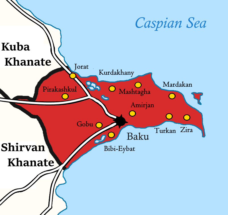
English: Map of the Baku Khanate in 1806. Azərbaycanca: Bakı xanlığının xəritəsi. |
| Datum | |
| Bron | Eigen werk. Based on Khanate of Baku in the Map of Caucasus with the borders.jpg, Azerbaijani khanates in the 18th-19th centuries.png, and Bakı xanlığı.jpg |
| Auteur | Aykhan Zayedzadeh |
Licentie
Ik, de auteursrechthebbende van dit werk, maak het hierbij onder de volgende licentie beschikbaar:
Dit bestand is gelicenseerd onder de Creative Commons-licentie Naamsvermelding-Gelijk delen 3.0 Unported
- De gebruiker mag:
- Delen – het werk kopiëren, verspreiden en doorgeven
- Remixen – afgeleide werken maken
- Onder de volgende voorwaarden:
- naamsvermelding – U moet op een gepaste manier aan naamsvermelding doen, een link naar de licentie geven, en aangeven of er wijzigingen in het werk zijn aangebracht. U mag dit op elke redelijke manier doen, maar niet zodanig dat de indruk wordt gewekt dat de licentiegever instemt met uw werk of uw gebruik van zijn werk.
- Gelijk delen – Als u het werk heeft geremixt, veranderd, of erop heeft voortgebouwd, moet u het gewijzigde materiaal verspreiden onder dezelfde licentie als het oorspronkelijke werk, of een daarmee compatibele licentie.
Bestandsgeschiedenis
Klik op een datum/tijd om het bestand te zien zoals het destijds was.
| Datum/tijd | Miniatuur | Afmetingen | Gebruiker | Opmerking | |
|---|---|---|---|---|---|
| huidige versie | 5 feb 2021 18:26 | | 800 × 754 (99 kB) | Solavirum | {{Information |description={{en|1=Map of the Baku Khanate.}}{{az|1=Bakı xanlığının xəritəsi.}} |date=2021-02-05 |source={{own}}. Based on Khanate of Baku in the Map of Caucasus with the borders.jpg, Azerbaijani khanates in the 18th-19th centuries.png, and Bakı xanlığı.jpg |author=Aykhan Zayedzadeh |permission= |other_... |
Bestandsgebruik
Dit bestand wordt op de volgende pagina gebruikt:
Globaal bestandsgebruik
De volgende andere wiki's gebruiken dit bestand:
- Gebruikt op azb.wikipedia.org
- Gebruikt op az.wikipedia.org
- Gebruikt op en.wikipedia.org
- Gebruikt op ka.wikipedia.org