
Bestand:March 2010 Turkey earthquake intensity USGS.jpg
Grootte van deze voorvertoning: 514 × 600 pixels. Andere resoluties: 206 × 240 pixels | 612 × 714 pixels.
Oorspronkelijk bestand (612 × 714 pixels, bestandsgrootte: 129 kB, MIME-type: image/jpeg)
| Dit is een bestand van Wikimedia Commons. Onderstaande beschrijving komt van de beschrijving van het bestand daar. |
Beschrijving
| Beschrijving |
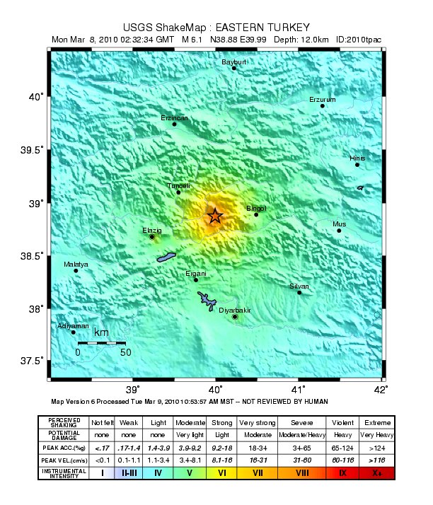
English: Shake map of the magnitude 6.1 earthquake occurring at Elâzığ, Turkey on March 8, 2010. Epicenter marked at star. Realized by USGS on March 8, 2010. |
|||
| Datum | ||||
| Bron | USGS | |||
| Auteur | United States Geological Survey | |||
| Toestemming (Hergebruik van dit bestand) |
|
Bestandsgeschiedenis
Klik op een datum/tijd om het bestand te zien zoals het destijds was.
| Datum/tijd | Miniatuur | Afmetingen | Gebruiker | Opmerking | |
|---|---|---|---|---|---|
| huidige versie | 20 mrt 2010 12:23 | | 612 × 714 (129 kB) | A7x | {{Information |Description={{en|1=Shake map of the magnitude 6.1 earthquake occurring at Elâzığ, Turkey on March 8, 2010. Epicenter marked at star. Realized by USGS on March 8, 2010.}} |Source=[http://earthquake.usgs.gov/earthquakes/shakemap/global/sha |
Bestandsgebruik
Dit bestand wordt op de volgende pagina gebruikt:
Globaal bestandsgebruik
De volgende andere wiki's gebruiken dit bestand:
- Gebruikt op ca.wikipedia.org
- Gebruikt op de.wikipedia.org
- Gebruikt op en.wikipedia.org
- Gebruikt op fr.wikipedia.org
- Gebruikt op id.wikipedia.org
- Gebruikt op ku.wikipedia.org
- Gebruikt op ms.wikipedia.org
- Gebruikt op pl.wikipedia.org
- Gebruikt op pt.wikipedia.org
- Gebruikt op ru.wikipedia.org
- Gebruikt op tr.wikipedia.org
- Gebruikt op uk.wikipedia.org
- Gebruikt op www.wikidata.org