
Bestand:McCurtainCounty1909.jpg
Grootte van deze voorvertoning: 423 × 600 pixels. Andere resoluties: 169 × 240 pixels | 478 × 678 pixels.
Oorspronkelijk bestand (478 × 678 pixels, bestandsgrootte: 111 kB, MIME-type: image/jpeg)
| Dit is een bestand van Wikimedia Commons. Onderstaande beschrijving komt van de beschrijving van het bestand daar. |
Beschrijving
| Beschrijving |
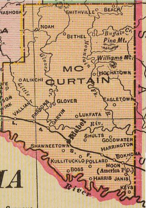
English: 1909 map of McCurtain County, Oklahoma. |
| Datum | |
| Bron | Oklahoma from the latest state and federal transportation surveys. Geo. F. Cram, Chicago and New York. (1909) |
| Auteur | Cram, George Franklin/Davis, Ellis Arthur |
Licentie
Dit mediabestand is in het publiek domein in de Verenigde Staten van Amerika. Dit geldt voor werken uit de VS waarvan de copyright is verlopen, meestal omdat de eerste publicatie ervan verscheen voor 1 januari 1929. Zie ook deze pagina voor verdere uitleg
|
 | |
 |
Let op! Dit bestand hoeft niet in het publiek domein te zijn buiten de VS (dit geldt voor Canada, China (excl. Hong Kong, Macao of Taiwan), Duitsland, Mexico en Zwitserland). De auteur en het jaar van publicatie zijn essentiële informatie en moeten zijn vastgesteld. Zie ook Wikipedia:Public domain en Wikipedia:Copyrights voor meer informatie.
|
Bestandsgeschiedenis
Klik op een datum/tijd om het bestand te zien zoals het destijds was.
| Datum/tijd | Miniatuur | Afmetingen | Gebruiker | Opmerking | |
|---|---|---|---|---|---|
| huidige versie | 29 jan 2010 04:31 | | 478 × 678 (111 kB) | Narthring | {{Information |Description={{en|1=1909 map of McCurtain County, Oklahoma.}} |Source=Oklahoma from the latest state and federal transportation surveys. Geo. F. Cram, Chicago and New York. (1909) |Author=Cram, George Franklin/Davis, Ellis Arthur |Date=1909 |
Bestandsgebruik
Dit bestand wordt op de volgende pagina gebruikt:
Globaal bestandsgebruik
De volgende andere wiki's gebruiken dit bestand:
- Gebruikt op en.wikipedia.org
- Gebruikt op ja.wikipedia.org