
Bestand:Miners Needle from Bluff Spring Trail, Superstition Wilderness.jpg

Oorspronkelijk bestand (3.648 × 2.736 pixels, bestandsgrootte: 2,3 MB, MIME-type: image/jpeg)
| Dit is een bestand van Wikimedia Commons. Onderstaande beschrijving komt van de beschrijving van het bestand daar. |
Beschrijving
| Beschrijving |
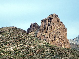
English: This is the view looking northeast at Miner's Needle from the Bluff Spring Trail. This area figures prominently in the legends of gold in the Supes. The Lost Dutchman's Mine is thought to be near here.
I hiked the Charleyboy Duece Loop - the hike shown as Charlebois Loop II in "Hiker's Guide to the Superstition Wilderness" by Jack Stewart and Liz Carlson. From Wikipedia: "The Superstition Mountains, popularly referred to as "The Superstitions" or "The Supes", are a range of mountains in Arizona located to the east of the Phoenix metropolitan area. They are anchored by Superstition Mountain, a large mountain that is a popular recreation destination for residents of the Phoenix, Arizona area. The mountain range is in the federally-designated Superstition Wilderness Area, and includes a variety of natural features in addition to the mountain that is its namesake. Weaver's Needle, a prominent landmark and rock climbing destination set behind and to the east of Superstition Mountain, is a tall erosional remnant [1] that plays a significant role in the legend of the Lost Dutchman's Gold Mine. Peralta Canyon, on the northeast side of Superstition Mountain, contains a popular trail that leads up to Freemont Saddle, which provides a very picturesque view of Weaver's Needle. Miner's Needle is another prominent formation in the wilderness and a popular hiking destination." |
| Datum | |
| Bron |
Miner's Needle from Bluff Spring Trail - Superstition Wilderness
|
| Auteur | Alan English CPA from Scottsdale, Arizona 85254, USA |
| Cameralocatie | | Deze en andere afbeeldingen in: OpenStreetMap |
|---|
Licentie
- De gebruiker mag:
- Delen – het werk kopiëren, verspreiden en doorgeven
- Remixen – afgeleide werken maken
- Onder de volgende voorwaarden:
- naamsvermelding – U moet op een gepaste manier aan naamsvermelding doen, een link naar de licentie geven, en aangeven of er wijzigingen in het werk zijn aangebracht. U mag dit op elke redelijke manier doen, maar niet zodanig dat de indruk wordt gewekt dat de licentiegever instemt met uw werk of uw gebruik van zijn werk.
- Gelijk delen – Als u het werk heeft geremixt, veranderd, of erop heeft voortgebouwd, moet u het gewijzigde materiaal verspreiden onder dezelfde licentie als het oorspronkelijke werk, of een daarmee compatibele licentie.
| Deze afbeelding, die oorspronkelijk op Flickr geplaatst is, is gecontroleerd op February 19, 2011 door de moderator of vertrouwde gebruiker File Upload Bot (Magnus Manske), die bevestigt dat het destijds beschikbaar was op Flickr onder de genoemde licentie. |
Bestandsgeschiedenis
Klik op een datum/tijd om het bestand te zien zoals het destijds was.
| Datum/tijd | Miniatuur | Afmetingen | Gebruiker | Opmerking | |
|---|---|---|---|---|---|
| huidige versie | 20 feb 2011 01:06 | | 3.648 × 2.736 (2,3 MB) | File Upload Bot (Magnus Manske) | {{Information |Description=This is the view looking northeast at Miner's Needle from the Bluff Spring Trail. This area figures prominently in the legends of gold in the Supes. The Lost Dutchman's Mine is thought to be near here. I hiked the Charleyboy |
Bestandsgebruik
Dit bestand wordt op de volgende pagina gebruikt:
Globaal bestandsgebruik
De volgende andere wiki's gebruiken dit bestand:
- Gebruikt op de.wikipedia.org
- Gebruikt op en.wikipedia.org
- Gebruikt op ja.wikipedia.org
- Gebruikt op pl.wikipedia.org
- Gebruikt op www.wikidata.org