
Bestand:Nemegtomaia maps.png

Grootte van deze voorvertoning: 800 × 407 pixels. Andere resoluties: 320 × 163 pixels | 640 × 326 pixels | 1.024 × 521 pixels | 1.280 × 651 pixels | 3.397 × 1.729 pixels.
Oorspronkelijk bestand (3.397 × 1.729 pixels, bestandsgrootte: 4,66 MB, MIME-type: image/png)
| Dit is een bestand van Wikimedia Commons. Onderstaande beschrijving komt van de beschrijving van het bestand daar. |
Beschrijving
| Beschrijving |
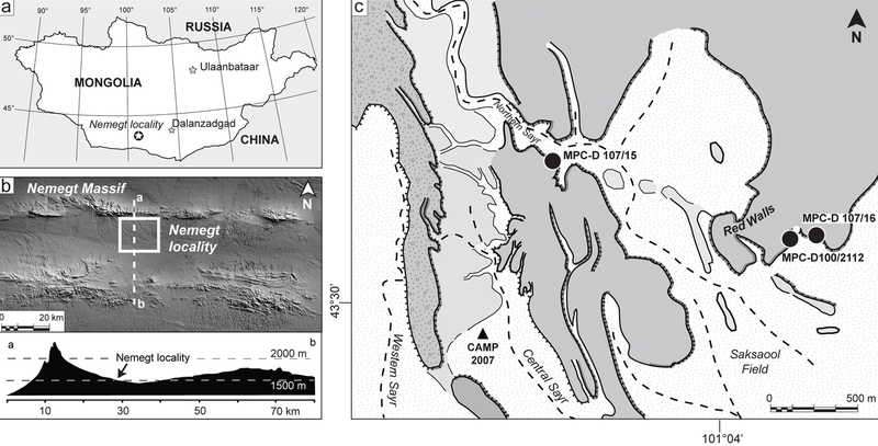
The Nemegt locality the Gobi Desert, southern Mongolia. A, map showing the location of the study area within southern Mongolia; B, the Nemegt area is located a few kilometers south of the massif of the same name; C, a detail of the Nemegt locality (sensu 5), showing the exact locations of Nemegtomaia specimens described in this study. |
| Datum | |
| Bron | http://www.plosone.org/article/info%3Adoi%2F10.1371%2Fjournal.pone.0031330 |
| Auteur | Federico Fanti, Philip J. Currie, Demchig Badamgarav |
Licentie
|
Dit bestand is gelicenseerd onder de Creative Commons-licentie Naamsvermelding 2.5 Unported
|
Deze afbeelding werd gepubliceerd in een Public Library of Science journal. Hun website stelt dat de inhoud van alle PLOS journals gepubliceerd is onder de Creative Commons Attribution 2.5 license.
Aan de uploader: je dient een link (URL) te geven naar het originele bestand of journal-artikel. |
Dit bestand, dat oorspronkelijk toegevoegd was op http://www.plosone.org/article/info%3Adoi%2F10.1371%2Fjournal.pone.0031330, werd op 30 maart 2016 beoordeeld door de moderator of reviewer Dyolf77, die bevestigt dat dit bestand beschikbaar was onder de vermelde licentie op die datum.
|
Bestandsgeschiedenis
Klik op een datum/tijd om het bestand te zien zoals het destijds was.
| Datum/tijd | Miniatuur | Afmetingen | Gebruiker | Opmerking | |
|---|---|---|---|---|---|
| huidige versie | 24 okt 2018 23:53 | | 3.397 × 1.729 (4,66 MB) | FunkMonk | Cropped 1 % horizontally, 1 % vertically using CropTool with precise mode. |
| 9 sep 2016 00:35 |  | 3.446 × 1.753 (4,72 MB) | FunkMonk | == {{int:filedesc}} == {{Information |Description=The Nemegt locality the Gobi Desert, southern Mongolia. A, map showing the location of the study area within southern Mongolia; B, the Nemegt area is located a few kilometers south of the massif of the... |
Bestandsgebruik
Dit bestand wordt op de volgende pagina gebruikt:
Globaal bestandsgebruik
De volgende andere wiki's gebruiken dit bestand:
- Gebruikt op de.wikipedia.org
- Gebruikt op en.wikipedia.org
- Gebruikt op es.wikipedia.org
- Gebruikt op fa.wikipedia.org
- Gebruikt op pl.wikipedia.org
- Gebruikt op zh.wikipedia.org