
Bestand:Nexco Systems Map.svg

Afmetingen van deze voorvertoning van het type PNG van dit SVG-bestand: 663 × 600 pixels Andere resoluties: 265 × 240 pixels | 531 × 480 pixels | 849 × 768 pixels | 1.132 × 1.024 pixels | 2.264 × 2.048 pixels | 735 × 665 pixels.
Oorspronkelijk bestand (SVG-bestand, nominaal 735 × 665 pixels, bestandsgrootte: 103 kB)
| Dit is een bestand van Wikimedia Commons. Onderstaande beschrijving komt van de beschrijving van het bestand daar. |
Beschrijving
| Beschrijving |
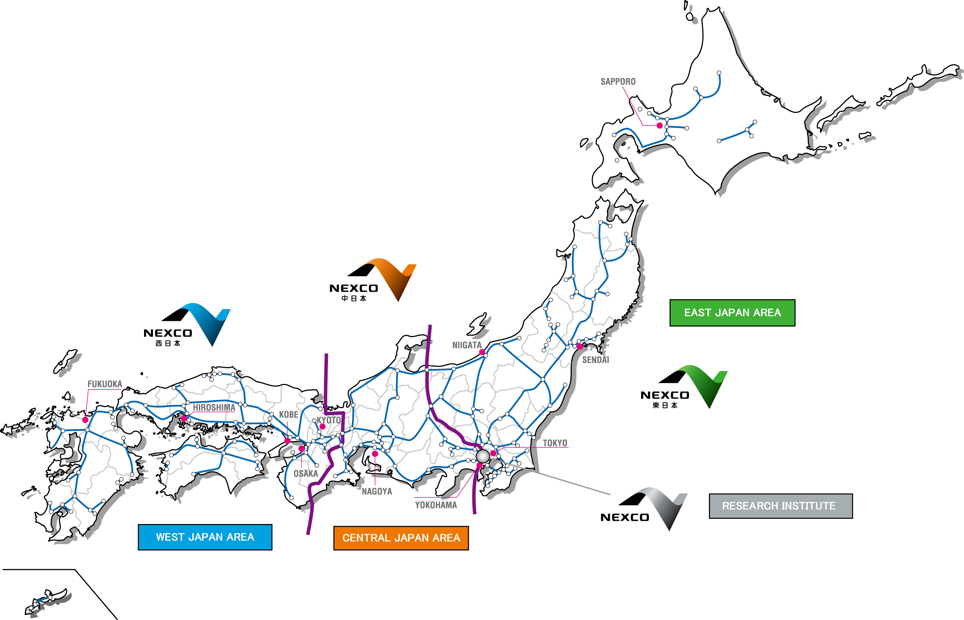
English: Map of the operational territories of the three major expressway companies in Japan, Nexco West, Nexco Central and Nexco East The black lines are prefecture boundaries. |
| Datum | |
| Bron |
Nexco Research Institute Map of company territories (Archived) Deze vectorafbeelding bevat onderdelen die afkomstig zijn uit van: |
| Auteur | The Navigators |
| Andere versies | Japan Highway Area.JPG - JPEG version. |
Licentie
| Ik, de auteursrechthebbende van dit werk, geef dit werk vrij in het publieke domein. Dit is wereldwijd van toepassing. In sommige landen is dit wettelijk niet mogelijk; in die gevallen geldt: Ik sta iedereen toe dit werk voor eender welk doel te gebruiken, zonder enige voorwaarden, tenzij zulke voorwaarden door de wet worden voorgeschreven. |

|
Deze tekst of afbeelding bevat materiaal dat mogelijk beschermd wordt door het merkenrecht in één of meer rechtsgebieden. Zorg dat u hebt vastgesteld dat u de content volgens het voor u geldende recht kunt inzetten. U bent verantwoordelijk voor het eventueel inbreuk maken op een merk van iemand anders. Zie onze general disclaimer. Deze banner zegt niets over de auteursrechten die van toepassing zijn. Een normale auteursrechten-tag is nodig. Zie Commons:Licensing voor meer informatie. |
Bestandsgeschiedenis
Klik op een datum/tijd om het bestand te zien zoals het destijds was.
| Datum/tijd | Miniatuur | Afmetingen | Gebruiker | Opmerking | |
|---|---|---|---|---|---|
| huidige versie | 11 mrt 2019 02:13 | | 735 × 665 (103 kB) | The Navigators | {{Information |description= {{en|1=Map of the operational territories of the three major expressway companies in Japan, Nexco West, Nexco Central and Nexco East The black lines are prefecture boundaries.}} |date= 10 March 2019 |source= Nexco Research Institute [http://www.ri-nexco.co.jp/Portals/0/images/contents/English/co_prjapan.jpg Map of company terr... |
Bestandsgebruik
Dit bestand wordt op de volgende 3 pagina's gebruikt:
Globaal bestandsgebruik
De volgende andere wiki's gebruiken dit bestand:
- Gebruikt op en.wikipedia.org
- Gebruikt op fr.wikipedia.org
- Gebruikt op ja.wikipedia.org
- Gebruikt op www.wikidata.org
- Gebruikt op zh.wikipedia.org