
Bestand:Oblast Pernik.png
Geen hogere resolutie beschikbaar.
Oblast_Pernik.png (202 × 134 pixels, bestandsgrootte: 2 kB, MIME-type: image/png)
| Dit is een bestand van Wikimedia Commons. Onderstaande beschrijving komt van de beschrijving van het bestand daar. |
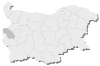
Beschrijving
- (Български) Тема: Карта на България с отбелязана Пернишка област.
- (Deutsch) Thema: Lage der Oblast Pernik in Bulgarien.
- (English) Subject: location map of Pernik Province in Bulgaria.
- (français) Objet : carte de localisation de l'oblast de Pernik en Bulgarie.
- Author: bg:Потребител:5ko (Петко Йотов = Petko Yotov, April 21, 2004) – The template map is created with MS Paint and IrfanView and is a "derivative work" from de:Bild:Sofia in BG.png (November 6, 2003, author Ronny Heidenreich, GFDL).
- Source: bg:Картинка:Oblast Pernik.png
Licentie

|
Toestemming wordt verleend voor het kopiëren, verspreiden en/of wijzigen van dit document onder de voorwaarden van de GNU-licentie voor vrije documentatie, versie 1.2 of enige latere versie als gepubliceerd door de Free Software Foundation; zonder Invariant Sections, zonder Front-Cover Texts, en zonder Back-Cover Texts. Een kopie van de licentie is opgenomen in de sectie GNU-licentie voor vrije documentatie. |
| Dit bestand is gelicenseerd onder de Creative Commons-licentie Naamsvermelding-Gelijk delen 3.0 Unported | ||
| ||
| Deze licentietag is toegevoegd aan dit bestand in verband met de GFDL licentie-update. |
Bestandsgeschiedenis
Klik op een datum/tijd om het bestand te zien zoals het destijds was.
| Datum/tijd | Miniatuur | Afmetingen | Gebruiker | Opmerking | |
|---|---|---|---|---|---|
| huidige versie | 10 apr 2006 06:02 | | 202 × 134 (2 kB) | Hégésippe Cormier | ==Summary== *(Български) '''Тема:''' Карта на България с отбелязана Пернишка област. *(Deutsch) '''Thema:''' Lage der Oblast Pernik in [[:de:Bulga |
Bestandsgebruik
Geen enkele pagina gebruikt dit bestand.
Globaal bestandsgebruik
De volgende andere wiki's gebruiken dit bestand:
- Gebruikt op en.wikipedia.org
- Batanovtsi
- Breznik
- Tran, Bulgaria
- Chervena Mogila
- Dushintsi
- Sirishtnik
- Zemen
- Nedelkovo
- Chuypetlovo
- Vrabcha
- Lyalintsi
- Prodancha
- Paramun
- Kovachevtsi, Pernik Province
- Yardzhilovtsi
- Category:Villages in Pernik Province
- 14th MMC – Pernik
- Bankya, Pernik Province
- Bogoyna
- Bohova, Bulgaria
- Butrointsi
- Dalga Luka
- Template:Pernik-geo-stub
- Velkovtsi, Pernik Province
- Zelenigrad
- Belanitsa
- Bosnek
- Gebruikt op fr.wikipedia.org
- Gebruikt op ko.wikipedia.org
- Gebruikt op la.wikipedia.org
- Gebruikt op mk.wikipedia.org
- Gebruikt op pt.wikipedia.org
- Gebruikt op ro.wikipedia.org
- Gebruikt op sv.wikipedia.org
- Gebruikt op tg.wikipedia.org
- Gebruikt op tt.wikipedia.org
- Gebruikt op uk.wikipedia.org
- Gebruikt op vi.wikipedia.org
- Gebruikt op war.wikipedia.org
- Gebruikt op www.wikidata.org
- Gebruikt op zh.wikipedia.org