
Bestand:Pennsylvania Railroad system map (1918).svg

Afmetingen van deze voorvertoning van het type PNG van dit SVG-bestand: 800 × 457 pixels Andere resoluties: 320 × 183 pixels | 640 × 366 pixels | 1.024 × 585 pixels | 1.280 × 731 pixels | 2.560 × 1.463 pixels | 1.400 × 800 pixels.
Oorspronkelijk bestand (SVG-bestand, nominaal 1.400 × 800 pixels, bestandsgrootte: 6,55 MB)
| Dit is een bestand van Wikimedia Commons. Onderstaande beschrijving komt van de beschrijving van het bestand daar. |
.svg)
Beschrijving
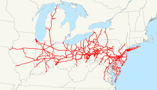
| Beschrijving | This is a map of the Pennsylvania Railroad system as of 1918, with trackage rights in purple and future lines dotted. The two disconnected pieces in West Virginia are not an error; they are remaining portions of the Little Kanawha Syndicate properties that were partially controlled by the PRR-owned Pennsylvania Company. Email me if you would like a copy of the GIS data I created (modified from Bureau of Transportation Statistics North American Transportation Atlas Data) or if you see any errors. |
| Datum | 18 maart 2009 (originele uploaddatum) |
| Bron | Geen machineleesbare bron opgegeven. Eigen werk aangenomen (gebaseerd op auteursrechtclaims). |
| Auteur | Geen machineleesbare auteur aanwezig. Op basis van auteursrechtclaims wordt auteur NE2 aangenomen. |
Licentie
| Ik, de auteursrechthebbende van dit werk, geef dit werk vrij in het publieke domein. Dit is wereldwijd van toepassing. In sommige landen is dit wettelijk niet mogelijk; in die gevallen geldt: Ik sta iedereen toe dit werk voor eender welk doel te gebruiken, zonder enige voorwaarden, tenzij zulke voorwaarden door de wet worden voorgeschreven. |
Bestandsgeschiedenis
Klik op een datum/tijd om het bestand te zien zoals het destijds was.
| Datum/tijd | Miniatuur | Afmetingen | Gebruiker | Opmerking | |
|---|---|---|---|---|---|
| huidige versie | 19 mrt 2009 05:23 | | 1.400 × 800 (6,55 MB) | NE2 | Fixed just a bit. |
| 18 mrt 2009 07:13 |  | 1.400 × 800 (6,53 MB) | NE2 | Changed the zoom slightly. | |
| 18 mrt 2009 06:49 |  | 1.400 × 800 (6,6 MB) | NE2 | == Summary == This is a map of the Pennsylvania Railroad system as of 1918, with trackage rights in purple and future lines dotted. The two disconnected pieces in West Virginia are not an error; they are remaining portions of the Li |
Bestandsgebruik
Dit bestand wordt op de volgende pagina gebruikt:
Globaal bestandsgebruik
De volgende andere wiki's gebruiken dit bestand:
- Gebruikt op de.wikipedia.org
- Gebruikt op et.wikipedia.org
- Gebruikt op fr.wikipedia.org
- Gebruikt op hu.wikipedia.org
- Gebruikt op it.wikipedia.org
- Gebruikt op ja.wikipedia.org
- Gebruikt op ko.wikipedia.org
- Gebruikt op pt.wikipedia.org
- Gebruikt op ru.wikipedia.org
- Gebruikt op www.wikidata.org
.svg)