
Bestand:Peta Kota Atambua.png
Grootte van deze voorvertoning: 655 × 599 pixels. Andere resoluties: 262 × 240 pixels | 525 × 480 pixels | 840 × 768 pixels | 1.119 × 1.024 pixels | 1.315 × 1.203 pixels.
Oorspronkelijk bestand (1.315 × 1.203 pixels, bestandsgrootte: 300 kB, MIME-type: image/png)
| Dit is een bestand van Wikimedia Commons. Onderstaande beschrijving komt van de beschrijving van het bestand daar. |
Beschrijving
| Beschrijving |
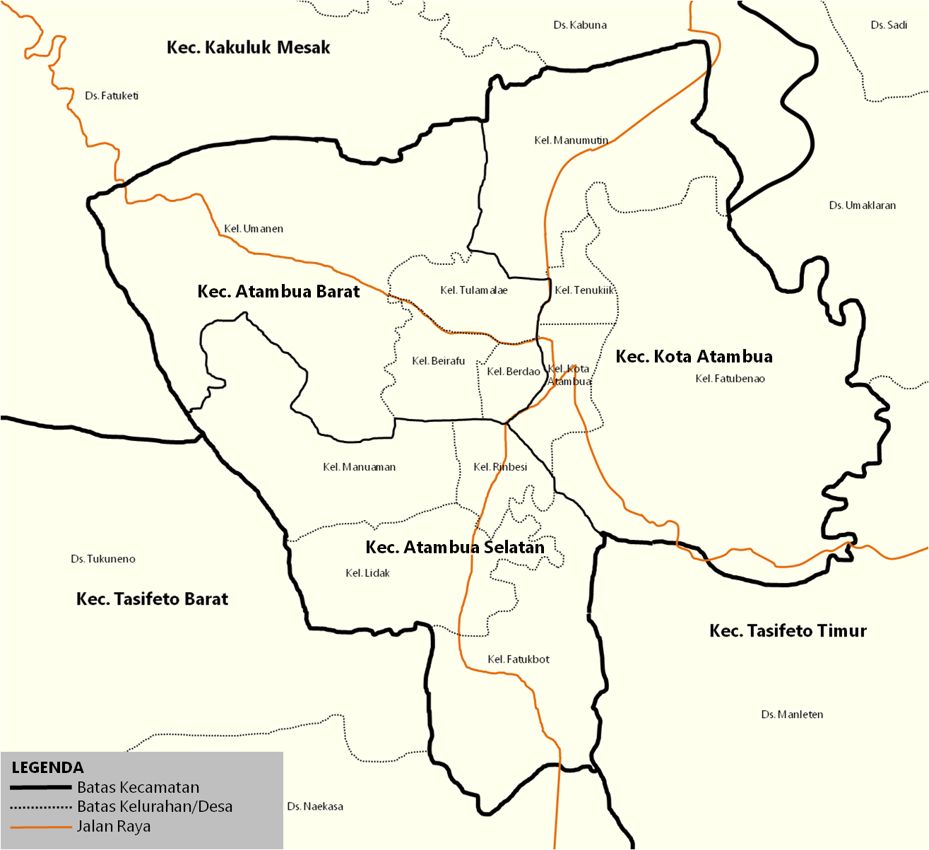
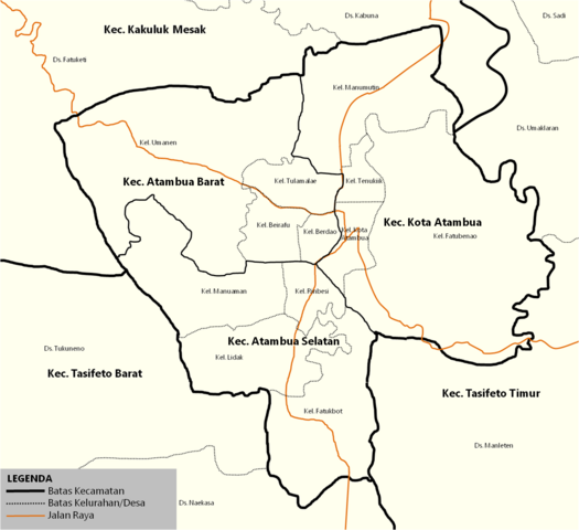
English: Map of the districts inside town of Atambua. Indonesia |
| Bron | id.wikipedia.org |
| Auteur | Jolly Frankle |
Licentie
| Ik, de auteursrechthebbende van dit werk, geef dit werk vrij in het publieke domein. Dit is wereldwijd van toepassing. In sommige landen is dit wettelijk niet mogelijk; in die gevallen geldt: Ik sta iedereen toe dit werk voor eender welk doel te gebruiken, zonder enige voorwaarden, tenzij zulke voorwaarden door de wet worden voorgeschreven. |
Oorspronkelijk uploadlogboek
De oorspronkelijke beschrijving van deze afbeelding stond hier. Alle volgende gebruikersnamen verwijzen naar id.wikipedia.
- 2017-07-14 09:37 JollyFrankle 1315×1203× (307479 bytes) Penambahan Legenda
- 2017-07-14 09:31 JollyFrankle 1315×1203× (306739 bytes) Nama Kelurahan, Jalan Raya, Kecamatan Tetangga
- 2017-07-11 03:24 JollyFrankle 1275×1190× (33933 bytes)
Bestandsgeschiedenis
Klik op een datum/tijd om het bestand te zien zoals het destijds was.
| Datum/tijd | Miniatuur | Afmetingen | Gebruiker | Opmerking | |
|---|---|---|---|---|---|
| huidige versie | 20 dec 2018 07:20 | | 1.315 × 1.203 (300 kB) | JollyFrankle | {{Information |description ={{en|1=Map of the districts inside town of Atambua. Indonesia}} |date = |source =id.wikipedia.org |author =Jolly Frankle }} == {{Original upload log}} == {{original description page|id.wikipedia|Peta_Kota_Atambua.png}} * 2017-07-14 09:37 JollyFrankle 1315×1203× (307479 bytes) ''<nowiki>Penambahan Legenda</nowiki>'' * 2017-07-14 09:31 JollyFrankle 1315×1203× (306739 bytes) ''<nowiki>Nama K... |
Bestandsgebruik
Dit bestand wordt op de volgende pagina gebruikt:
Globaal bestandsgebruik
De volgende andere wiki's gebruiken dit bestand:
- Gebruikt op ar.wikipedia.org
- Gebruikt op ban.wikipedia.org
- Gebruikt op ceb.wikipedia.org
- Gebruikt op de.wikipedia.org
- Gebruikt op en.wikivoyage.org
- Gebruikt op id.wikipedia.org
- Kota Atambua, Belu
- Templat:Kota Atambua
- Atambua Selatan, Belu
- Atambua, Atambua, Belu
- Fatubenao, Atambua, Belu
- Manumutin, Atambua, Belu
- Tenukiik, Atambua, Belu
- SMA Negeri 1 Atambua
- Bandar Udara A. A. Bere Tallo
- Atambua
- Transportasi di Kota Atambua
- HUT Kota Atambua
- SMA Katolik Suria Atambua
- Kategori:Kota Atambua
- Sejarah Kota Atambua
- Gebruikt op pl.wikipedia.org
- Gebruikt op www.wikidata.org