
Bestand:Puertoprincesa chart4343 1904.jpeg
Grootte van deze voorvertoning: 715 × 600 pixels. Andere resoluties: 286 × 240 pixels | 572 × 480 pixels | 916 × 768 pixels | 1.221 × 1.024 pixels | 2.442 × 2.048 pixels | 3.053 × 2.561 pixels.
Oorspronkelijk bestand (3.053 × 2.561 pixels, bestandsgrootte: 1,31 MB, MIME-type: image/jpeg)
| Dit is een bestand van Wikimedia Commons. Onderstaande beschrijving komt van de beschrijving van het bestand daar. |
| Beschrijving |
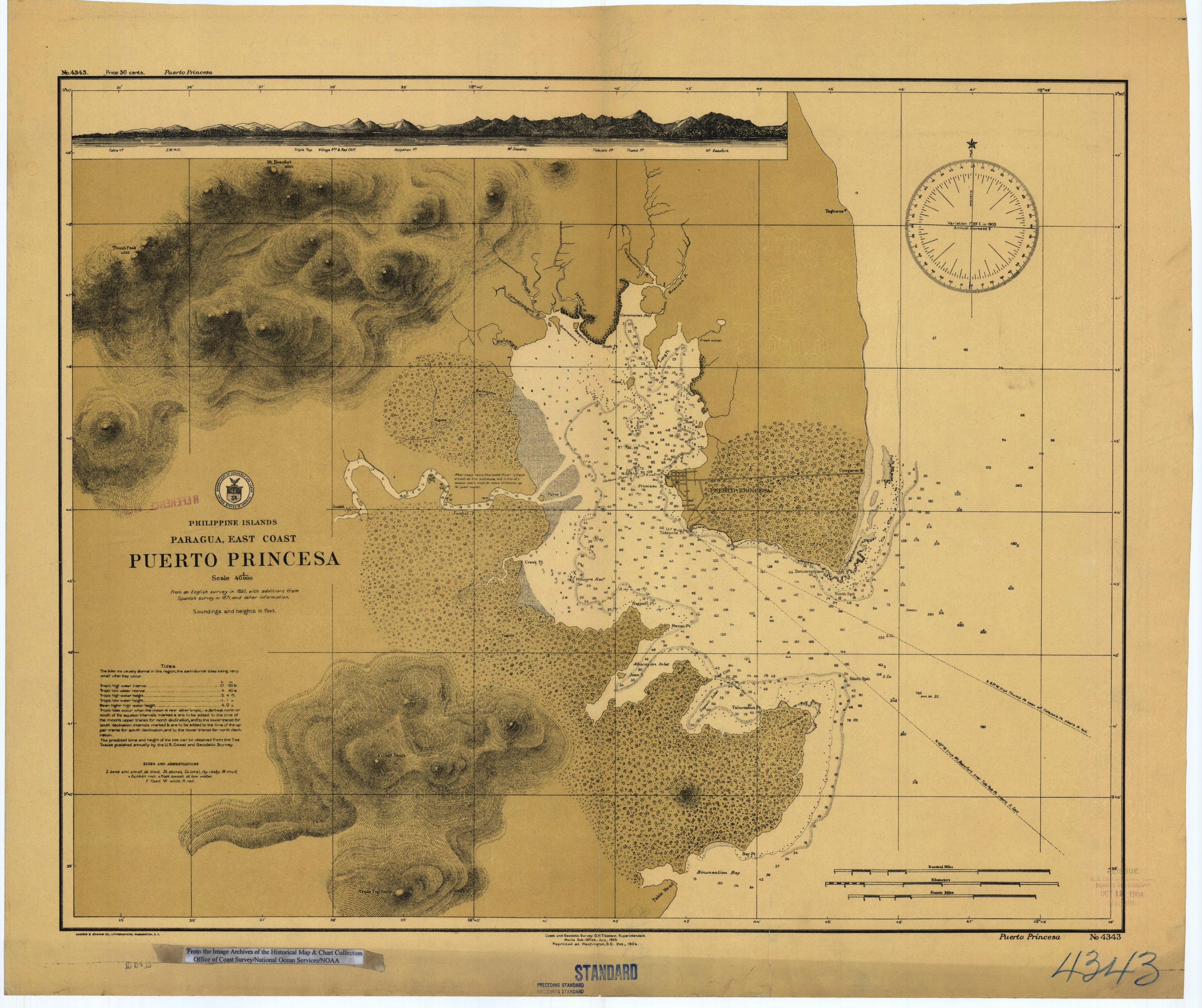
English: Scanned image of US Coast & Geodetic Survey (Manila Office) nautical chart #4343 Puerto Princesa, (Paragua), Palawan, Philippines. |
|||
| Datum | ||||
| Bron |
English: From the image archives of the Historical Map & Chart Collection/Office of Coast Survey/National Ocean Service/NOAA/United States government. Converted from MrSID to JPEG format for upload to Commons. |
|||
| Auteur | Coast and Geodetic Survey O.H. Tittmann, Superintendent. Manila Sub-Office. July 1903 | |||
| Toestemming (Hergebruik van dit bestand) |
|
Bestandsgeschiedenis
Klik op een datum/tijd om het bestand te zien zoals het destijds was.
| Datum/tijd | Miniatuur | Afmetingen | Gebruiker | Opmerking | |
|---|---|---|---|---|---|
| huidige versie | 17 mrt 2006 03:41 | | 3.053 × 2.561 (1,31 MB) | Cdc~commonswiki | Scanned image of US Coast & Geodetic Survey (Manila Office) nautical chart #4343 Puerto Princesa, (Paragua), Palawan, Philippines, 1904. From the Image Archives of the [http://chartmaker.ncd.noaa.gov/csdl/ctp/abstract.htm Historical Map & Chart Collecti |
Bestandsgebruik
Geen enkele pagina gebruikt dit bestand.
Globaal bestandsgebruik
De volgende andere wiki's gebruiken dit bestand:
- Gebruikt op en.wikipedia.org
- Gebruikt op es.wikipedia.org
- Gebruikt op ja.wikipedia.org
- Gebruikt op ka.wikipedia.org
- Gebruikt op ko.wikipedia.org
- Gebruikt op pam.wikipedia.org
- Gebruikt op pt.wikipedia.org
- Gebruikt op tl.wikipedia.org