
Bestand:Saint Helena-CIA WFB Map.png
Grootte van deze voorvertoning: 280 × 598 pixels. Andere resoluties: 112 × 240 pixels | 331 × 707 pixels.
Oorspronkelijk bestand (331 × 707 pixels, bestandsgrootte: 5 kB, MIME-type: image/png)
| Dit is een bestand van Wikimedia Commons. Onderstaande beschrijving komt van de beschrijving van het bestand daar. |
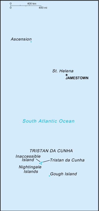
Beschrijving
Español: Mapa de la dependencia de Santa Helena
Slovene version: Image:Saint Helena-CIA WFB Map-sl.png
Deze afbeelding bevindt zich in het publiek domein omdat het materiaal bevat dat oorspronkelijk afkomstig is van het CIA World Factbook.
|
 |
Bestandsgeschiedenis
Klik op een datum/tijd om het bestand te zien zoals het destijds was.
| Datum/tijd | Miniatuur | Afmetingen | Gebruiker | Opmerking | |
|---|---|---|---|---|---|
| huidige versie | 14 nov 2010 08:40 | | 331 × 707 (5 kB) | Hoshie | Reverted to version as of 09:17, 27 March 2005: a newer map is at Image:Saint Helena, Ascension, and Tristan da Cunha-CIA WFB Map.png |
| 17 feb 2006 10:27 |  | 329 × 713 (8 kB) | Hoshie | Updated map of St. Helena (and dependencies) from the CIA World Factbook, 10 Jan 06 rev. : http://www.cia.gov/cia/publications/factbook/maps/sh-map.gif | |
| 27 mrt 2005 11:17 |  | 331 × 707 (5 kB) | Wolfman~commonswiki | {{CIA-map}} |
Bestandsgebruik
Geen enkele pagina gebruikt dit bestand.
Globaal bestandsgebruik
De volgende andere wiki's gebruiken dit bestand:
- Gebruikt op ace.wikipedia.org
- Gebruikt op ar.wikipedia.org
- Gebruikt op ast.wikipedia.org
- Gebruikt op ckb.wikipedia.org
- Gebruikt op el.wikipedia.org
- Gebruikt op en.wikipedia.org
- Gebruikt op en.wikisource.org
- Gebruikt op eo.wikipedia.org
- Gebruikt op es.wikipedia.org
- Gebruikt op es.wikivoyage.org
- Gebruikt op fr.wikipedia.org
- Gebruikt op gl.wikipedia.org
- Gebruikt op hu.wikipedia.org
- Gebruikt op id.wikipedia.org
- Gebruikt op jv.wikipedia.org
- Gebruikt op no.wikipedia.org
- Gebruikt op pl.wikipedia.org
- Gebruikt op pl.wiktionary.org
- Gebruikt op simple.wikipedia.org
- Gebruikt op zh-min-nan.wikipedia.org