
Bestand:Scotland topographic map-en.jpg
Grootte van deze voorvertoning: 417 × 599 pixels. Andere resoluties: 167 × 240 pixels | 334 × 480 pixels | 534 × 768 pixels | 712 × 1.024 pixels | 2.400 × 3.450 pixels.
Oorspronkelijk bestand (2.400 × 3.450 pixels, bestandsgrootte: 2,29 MB, MIME-type: image/jpeg)
| Dit is een bestand van Wikimedia Commons. Onderstaande beschrijving komt van de beschrijving van het bestand daar. |
Beschrijving
| Cameralocatie | | Deze en andere afbeeldingen in: OpenStreetMap |
|---|
| Beschrijving |
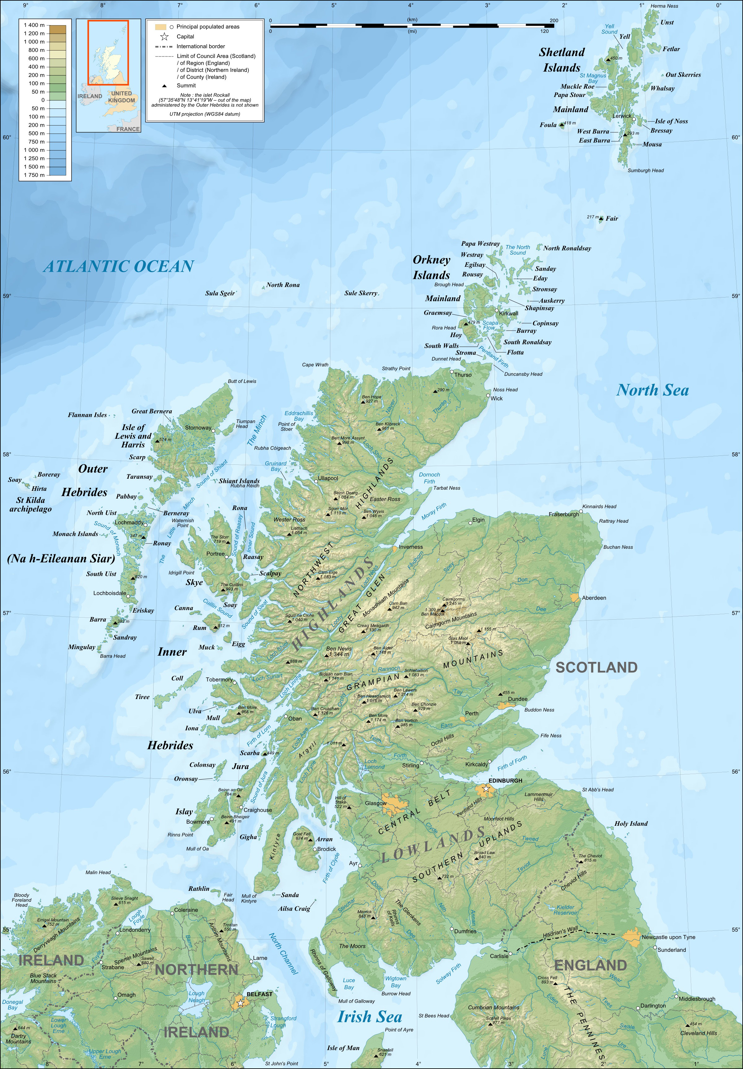
English: Topographic map in English of Scotland
This is a lighter raster JPG format version of Image:Scotland_topographic_map-en.svg which should be used in the article pages, the vector graphics version purpose being for modification and / or translation. Français : Carte topographique en anglais de l'Écosse.
Ceci est une version bitmap au format JPG et de poids de fichier plus léger de Image:Scotland_topographic_map-fr.svg qui devrait être utilisée dans les pages d'articles, la version vectorisée SVG étant destinée à faciliter les modifications et / ou traductions.
|
||
| Datum | December 2007 (modified 09-2008) | ||
| Bron |
Own work ;
|
||
| Auteur | Eric Gaba (Sting – fr:Sting) | ||
| Toestemming (Hergebruik van dit bestand) |
|
||
| Andere versies |
Afgeleide werken van dit bestand: River Forth course 3.png
[]
|


Licentie
Ik, de auteursrechthebbende van dit werk, maak het hierbij onder de volgende licenties beschikbaar:

|
Toestemming wordt verleend voor het kopiëren, verspreiden en/of wijzigen van dit document onder de voorwaarden van de GNU-licentie voor vrije documentatie, versie 1.2 of enige latere versie als gepubliceerd door de Free Software Foundation; zonder Invariant Sections, zonder Front-Cover Texts, en zonder Back-Cover Texts. Een kopie van de licentie is opgenomen in de sectie GNU-licentie voor vrije documentatie. |
This file is licensed under the Creative Commons Attribution-Share Alike 4.0 International, 3.0 Unported, 2.5 Generic, 2.0 Generic and 1.0 Generic license.
- De gebruiker mag:
- Delen – het werk kopiëren, verspreiden en doorgeven
- Remixen – afgeleide werken maken
- Onder de volgende voorwaarden:
- naamsvermelding – U moet op een gepaste manier aan naamsvermelding doen, een link naar de licentie geven, en aangeven of er wijzigingen in het werk zijn aangebracht. U mag dit op elke redelijke manier doen, maar niet zodanig dat de indruk wordt gewekt dat de licentiegever instemt met uw werk of uw gebruik van zijn werk.
- Gelijk delen – Als u het werk heeft geremixt, veranderd, of erop heeft voortgebouwd, moet u het gewijzigde materiaal verspreiden onder dezelfde licentie als het oorspronkelijke werk, of een daarmee compatibele licentie.
U mag zelf één van de licenties kiezen.
Bestandsgeschiedenis
Klik op een datum/tijd om het bestand te zien zoals het destijds was.
| Datum/tijd | Miniatuur | Afmetingen | Gebruiker | Opmerking | |
|---|---|---|---|---|---|
| huidige versie | 17 jul 2010 23:41 | | 2.400 × 3.450 (2,29 MB) | Sting | Color profile |
| 25 sep 2008 01:35 |  | 2.400 × 3.450 (1,99 MB) | Sting | Completely new background : raster topography and using ETOPO1 data for bathymetry ; new standard colors | |
| 14 dec 2007 03:02 |  | 2.400 × 3.450 (2,12 MB) | Sting | Additional name | |
| 12 dec 2007 22:55 |  | 2.400 × 3.450 (2,12 MB) | Sting | Correction in key | |
| 12 dec 2007 18:18 |  | 2.400 × 3.450 (2,12 MB) | Sting | {{Location|57|00|00|N|04|00|00|W|scale:4000000}} <br/> {{Information |Description=Topographic map in English of Scotland<br/>This is a lighter raster JPG format version of Image:Scotland_topographic_map-en.svg which should be used in |
Bestandsgebruik
Geen enkele pagina gebruikt dit bestand.
Globaal bestandsgebruik
De volgende andere wiki's gebruiken dit bestand:
- Gebruikt op en.wikipedia.org
- Gebruikt op es.wikipedia.org
- Gebruikt op ga.wiktionary.org
- Gebruikt op gd.wikipedia.org
- Gebruikt op hu.wikipedia.org
- Gebruikt op id.wikipedia.org
- Gebruikt op lt.wikipedia.org
- Gebruikt op so.wikipedia.org
- Gebruikt op to.wikipedia.org
- Gebruikt op uk.wikipedia.org