
Bestand:Shropshire UK location map.svg

Afmetingen van deze voorvertoning van het type PNG van dit SVG-bestand: 550 × 599 pixels Andere resoluties: 220 × 240 pixels | 441 × 480 pixels | 705 × 768 pixels | 940 × 1.024 pixels | 1.880 × 2.048 pixels | 1.198 × 1.305 pixels.
Oorspronkelijk bestand (SVG-bestand, nominaal 1.198 × 1.305 pixels, bestandsgrootte: 2,13 MB)
| Dit is een bestand van Wikimedia Commons. Onderstaande beschrijving komt van de beschrijving van het bestand daar. |
| Beschrijving |
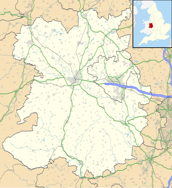
Map of Shropshire, UK with the following information shown:
Equirectangular map projection on WGS 84 datum, with N/S stretched 165% Geographic limits:
|
| Datum | |
| Bron |
|
| Auteur | Nilfanion, created using Ordnance Survey data |
| Toestemming (Hergebruik van dit bestand) |
Dit bestand is gelicenseerd onder de Creative Commons-licentie Naamsvermelding-Gelijk delen 3.0 Unported Naamsvermelding: Contains Ordnance Survey data © Crown copyright and database right
|
| Andere versies | File:Shropshire UK district map (blank).svg - Blank map |
.svg)
Bestandsgeschiedenis
Klik op een datum/tijd om het bestand te zien zoals het destijds was.
| Datum/tijd | Miniatuur | Afmetingen | Gebruiker | Opmerking | |
|---|---|---|---|---|---|
| huidige versie | 16 okt 2010 21:51 | | 1.198 × 1.305 (2,13 MB) | Nilfanion | fix to A442 |
| 26 sep 2010 21:11 |  | 1.198 × 1.305 (2,12 MB) | Nilfanion | {{Information |Description=Map of Shropshire, UK with the following information shown: *Administrative borders *Coastline, lakes and rivers *Roads and railways *Urban areas Equirectangular map projection on WGS 84 datum, with N/S stretch |
Bestandsgebruik
Dit bestand wordt op de volgende 64 pagina's gebruikt:
- Adderley
- Albrighton
- All Stretton
- Ashford Bowdler
- Ashford Carbonel
- Atcham
- Badger (Engeland)
- Bayston Hill
- Berrington
- Bettws-y-Crwyn
- Bishop's Castle
- Bridgnorth
- Broseley
- Bucknell (Shropshire)
- Burwarton
- Cardington (Shropshire)
- Chelmarsh
- Cheswardine
- Church Stretton
- Cleobury Mortimer
- Clive (Shropshire)
- Clun
- Coalbrookdale
- Condover
- Cound
- Craven Arms
- Dawley
- Eardington
- Ellesmere (Shropshire)
- Eyton upon the Weald Moors
- Highley
- Hinstock
- Hopton Castle
- Ironbridge
- Ketley
- Kinnerley
- Knockin
- Kynnersley
- Llanfair Waterdine
- Loppington
- Ludlow (Shropshire)
- Lydham
- Madeley (Shropshire)
- Market Drayton
- Milson
- Much Wenlock
- Newport (Shropshire)
- Oakengates
- Oswestry (plaats)
- Ruyton-XI-Towns
- Shawbury
- Shifnal
- Shrewsbury (Engeland)
- Sibdon Carwood
- Stanton Lacy
- Stoke upon Tern
- Telford (Engeland)
- Wellington (Shropshire)
- Wem
- Whitchurch (Shropshire)
- Whixall
- Woolstaston
- Wroxeter (Engeland)
- Sjabloon:Positiekaart Shropshire
Globaal bestandsgebruik
De volgende andere wiki's gebruiken dit bestand:
- Gebruikt op ar.wikipedia.org
- Gebruikt op azb.wikipedia.org
- Gebruikt op bg.wikipedia.org
- Gebruikt op ceb.wikipedia.org
- Gebruikt op cy.wikipedia.org
- Gebruikt op en.wikipedia.org
- Ludlow
- Ironbridge
- Stokesay Castle
- Telford
- Ludlow Castle
- Church Stretton
- Newport, Shropshire
- Oswestry
- Old Oswestry
- Whitchurch, Shropshire
- Market Drayton
- Bishop's Castle
- Bridgnorth
- Ellesmere, Shropshire
- Alveley
- Baschurch
- Woore
- Ruyton-XI-Towns
- Viroconium Cornoviorum
- Sheriffhales
- Weston Lullingfields
- Wroxeter
- Hampton Loade
- Clun
- Coalbrookdale
- Atcham
- Clun Castle
- Shawbury
- Shrewsbury Castle
- Attingham Park
- Wellington, Shropshire
- Oakengates
- Donnington, Telford
- Wem
- RAF Shawbury
- Much Wenlock
- Hopton Heath
- Sundorne
- Harlescott
- Ditherington
- Nesscliffe
- Cleobury Mortimer
- Hay Inclined Plane
- Snailbeach
- Pontesbury
Globaal gebruik van dit bestand bekijken.