
Bestand:Spice Islands (Zanzibar highlighted).svg

Afmetingen van deze voorvertoning van het type PNG van dit SVG-bestand: 486 × 599 pixels Andere resoluties: 195 × 240 pixels | 389 × 480 pixels | 623 × 768 pixels | 831 × 1.024 pixels | 1.662 × 2.048 pixels | 512 × 631 pixels.
Oorspronkelijk bestand (SVG-bestand, nominaal 512 × 631 pixels, bestandsgrootte: 6,08 MB)
| Dit is een bestand van Wikimedia Commons. Onderstaande beschrijving komt van de beschrijving van het bestand daar. |
.svg)
Beschrijving
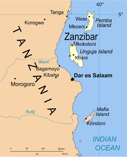
| Beschrijving | Part of the map of Tanzania, showing the Spice Islands, and highlighting Zanzibar. |
| Datum | |
| Bron | Vectors self-made in Inkscape. Source was cropped from 2003 Political map of Tanzania at Perry-Castañeda Library Map Collection — Tanzania. The maps are attributed to the US Central Intelligence Agency. |
| Auteur | Mysid |
| Andere versies |
Afgeleide werken van dit bestand: Image:Spice Islands (Tanzania).svgin French : Image:Spice_Islands_Tanzania-fr.svg in French : Image:Spice_Islands-Zanzibar_highlighted-fr.svg in Arabic: Image:Spice Islands (Zanzibar highlighted)-ar.svg |
| SVG ontwikkeling |
_el.svg)
_sv.svg)
.svg)
-ar.svg)
Licentie
| Ik, de auteursrechthebbende van dit werk, geef dit werk vrij in het publieke domein. Dit is wereldwijd van toepassing. In sommige landen is dit wettelijk niet mogelijk; in die gevallen geldt: Ik sta iedereen toe dit werk voor eender welk doel te gebruiken, zonder enige voorwaarden, tenzij zulke voorwaarden door de wet worden voorgeschreven. |
Bestandsgeschiedenis
Klik op een datum/tijd om het bestand te zien zoals het destijds was.
| Datum/tijd | Miniatuur | Afmetingen | Gebruiker | Opmerking | |
|---|---|---|---|---|---|
| huidige versie | 9 okt 2021 04:16 | | 512 × 631 (6,08 MB) | Nwbeeson | Zanzibar Island renamed to Unguja Island to match article caption |
| 6 jan 2007 22:09 |  | 713 × 879 (15 kB) | Mysid | higlighting Pemba as well | |
| 6 jan 2007 22:06 |  | 713 × 879 (15 kB) | Mysid | == Summary == {{Information |Description=Part of the map of Tanzania, showing the Spice Islands, and highlighting Zanzibar. |Source=Vectors self-made in Inkscape. Source was cropped from http://www.lib.utexas.edu/maps/africa/tanzania_p |
Bestandsgebruik
Dit bestand wordt op de volgende 2 pagina's gebruikt:
Globaal bestandsgebruik
De volgende andere wiki's gebruiken dit bestand:
- Gebruikt op af.wikipedia.org
- Gebruikt op ar.wikipedia.org
- Gebruikt op ast.wikipedia.org
- Gebruikt op ast.wiktionary.org
- Gebruikt op azb.wikipedia.org
- Gebruikt op az.wikipedia.org
- Gebruikt op ba.wikipedia.org
- Gebruikt op bg.wikipedia.org
- Gebruikt op bn.wikipedia.org
- Gebruikt op br.wikipedia.org
- Gebruikt op ca.wikipedia.org
- Gebruikt op cs.wikipedia.org
- Gebruikt op de.wikipedia.org
- Gebruikt op en.wikipedia.org
- Gebruikt op eo.wikipedia.org
- Gebruikt op eu.wikipedia.org
- Gebruikt op fa.wikipedia.org
- Gebruikt op fiu-vro.wikipedia.org
- Gebruikt op fr.wikipedia.org
- Gebruikt op gd.wikipedia.org
- Gebruikt op gl.wikipedia.org
- Gebruikt op ha.wikipedia.org
- Gebruikt op hr.wikipedia.org
- Gebruikt op hy.wikipedia.org
- Gebruikt op id.wikipedia.org
- Gebruikt op it.wikipedia.org
- Gebruikt op it.wikivoyage.org
- Gebruikt op ja.wikipedia.org
- Gebruikt op ka.wikipedia.org
- Gebruikt op ko.wikipedia.org
- Gebruikt op ku.wikipedia.org
- Gebruikt op lt.wikipedia.org
- Gebruikt op lv.wikipedia.org
- Gebruikt op mg.wikipedia.org
- Gebruikt op no.wikipedia.org
Globaal gebruik van dit bestand bekijken.
.svg)
.svg)