
Bestand:Utrecht hill ridge netherlands.svg

Afmetingen van deze voorvertoning van het type PNG van dit SVG-bestand: 480 × 599 pixels Andere resoluties: 192 × 240 pixels | 385 × 480 pixels | 616 × 768 pixels | 821 × 1.024 pixels | 1.642 × 2.048 pixels | 485 × 605 pixels.
Oorspronkelijk bestand (SVG-bestand, nominaal 485 × 605 pixels, bestandsgrootte: 24 kB)
| Dit is een bestand van Wikimedia Commons. Onderstaande beschrijving komt van de beschrijving van het bestand daar. |
Beschrijving
| Beschrijving |
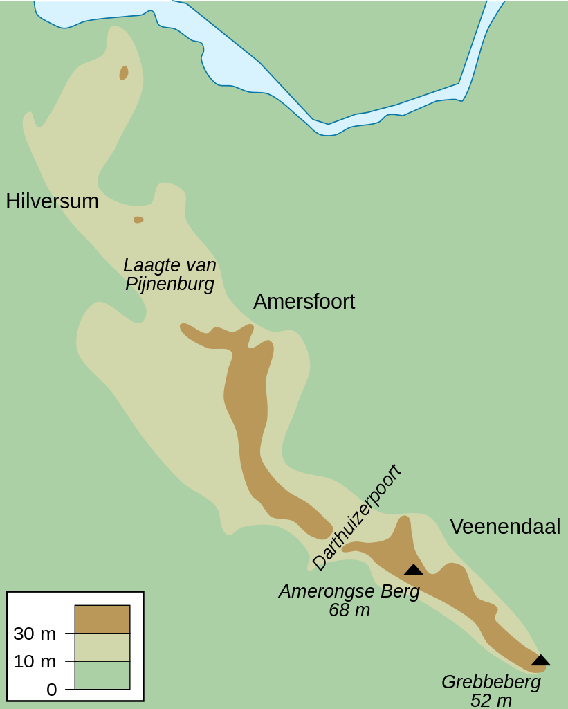
English: Map of the Utrecht Hill Ridge, a chain of hills located largely in the province of Utrecht, the Netherlands. The map shows the 10 m and 30 m contour lines, the two main peaks and the general location of several towns in the area.
Nederlands: Kaart van de Utrechtse Heuvelrug, grotendeels gelegen in de Nederlandse provincie Utrecht. De kaart toont de 10-meterlijn, de 30-meterlijn, de twee bekendste toppen en de ruwe locatie van een aantal naburige plaatsen. |
| Datum | |
| Bron | Eigen werk |
| Auteur | DennisM |
Licentie
| Ik, de auteursrechthebbende van dit werk, geef dit werk vrij in het publieke domein. Dit is wereldwijd van toepassing. In sommige landen is dit wettelijk niet mogelijk; in die gevallen geldt: Ik sta iedereen toe dit werk voor eender welk doel te gebruiken, zonder enige voorwaarden, tenzij zulke voorwaarden door de wet worden voorgeschreven. |
Bestandsgeschiedenis
Klik op een datum/tijd om het bestand te zien zoals het destijds was.
| Datum/tijd | Miniatuur | Afmetingen | Gebruiker | Opmerking | |
|---|---|---|---|---|---|
| huidige versie | 25 jul 2010 12:50 | | 485 × 605 (24 kB) | DennisM | {{Information |Description={{en|1=Map of the Utrecht Hill Ridge, a chain of hills located largely in the province of Utrecht, the Netherlands. The map shows the 10 m and 30 m contour lines, the two main peaks and the general location of several towns in t |
Bestandsgebruik
Dit bestand wordt op de volgende 2 pagina's gebruikt:
Globaal bestandsgebruik
De volgende andere wiki's gebruiken dit bestand:
- Gebruikt op en.wikipedia.org
- Gebruikt op fr.wikipedia.org
- Gebruikt op fy.wikipedia.org
- Gebruikt op li.wikipedia.org
- Gebruikt op sl.wikipedia.org
- Gebruikt op www.wikidata.org