
Bestand:Viceroyalty of the New Spain 1800 (without Philippines).png

Oorspronkelijk bestand (1.600 × 1.192 pixels, bestandsgrootte: 645 kB, MIME-type: image/png)
| Dit is een bestand van Wikimedia Commons. Onderstaande beschrijving komt van de beschrijving van het bestand daar. |

|
Bestand:Mapa del Virreinato de la Nueva España (1794).svg is een vectorversie van dit bestand. Indien niet van slechtere kwaliteit dient deze gebruikt te worden in plaats van deze rasterafbeelding.
File:Viceroyalty of the New Spain 1800 (without Philippines).png → File:Mapa del Virreinato de la Nueva España (1794).svg
Zie Help:SVG voor meer informatie. |
.svg) |
Beschrijving

| Beschrijving |
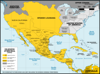
Español: Mapa del Virreinato de Nueva España en 1800. Sin incluir los territorios de ultramar en el Oceano Pacífico.
English: Map of the Viceroyalty of New Spain in 1800. Not including the viceroyalty's overseas territories in the Pacific Ocean.
Territorial organization of the Viceroyalty of New Spain (1535-1786)
Territorial organization of the Viceroyalty of New Spain (1786-1821)
|
||
| Datum | |||
| Bron |
A map created using information from the United States Geological Survey, an agency of the United States Department of Interior 1800, 1810, 1820 and from the Secretary of the Public Education of Mexico (Secretaría de Educación Pública de México) with 500 años de documentos COMMENT on 1 April 2015: The map above is still captioned "1810," instead of 1800. This is unfortunate and confusing, because in 1803 Spanish Louisiana was tranferred (to France and then) to the United States, so it makes the map appear to contain a serious error. ‘’’COMMENT on 13 August 2023: Date on the map above has still not been corrected to the actual year it represents, 1800. This leads to several inaccuracies, including for example misrepresentation of the size of the United States. In 1803 Ohio became a state, so it was no longer a territory by 1810. Such things were quickly changing in the 1800s, and the date on this map should be corrected.’’’ |
||
| Auteur | Giggette | ||
| Andere versies |
|

.png)
.png)
.png)
.png#Disputed)
| Cameralocatie | | Deze en andere afbeeldingen in: OpenStreetMap |
|---|
.png¶ms=019.409500_N_-099.130700_E_globe:Earth_type:camera_type:satellite_region:MX_heading:0.00&language=nl)
Licentie
- De gebruiker mag:
- Delen – het werk kopiëren, verspreiden en doorgeven
- Remixen – afgeleide werken maken
- Onder de volgende voorwaarden:
- naamsvermelding – U moet op een gepaste manier aan naamsvermelding doen, een link naar de licentie geven, en aangeven of er wijzigingen in het werk zijn aangebracht. U mag dit op elke redelijke manier doen, maar niet zodanig dat de indruk wordt gewekt dat de licentiegever instemt met uw werk of uw gebruik van zijn werk.
- Gelijk delen – Als u het werk heeft geremixt, veranderd, of erop heeft voortgebouwd, moet u het gewijzigde materiaal verspreiden onder dezelfde licentie als het oorspronkelijke werk, of een daarmee compatibele licentie.

|
Toestemming wordt verleend voor het kopiëren, verspreiden en/of wijzigen van dit document onder de voorwaarden van de GNU-licentie voor vrije documentatie, versie 1.2 of enige latere versie als gepubliceerd door de Free Software Foundation; zonder Invariant Sections, zonder Front-Cover Texts, en zonder Back-Cover Texts. Een kopie van de licentie is opgenomen in de sectie GNU-licentie voor vrije documentatie. |
Bestandsgeschiedenis
Klik op een datum/tijd om het bestand te zien zoals het destijds was.
| Datum/tijd | Miniatuur | Afmetingen | Gebruiker | Opmerking | |
|---|---|---|---|---|---|
| huidige versie | 21 nov 2016 04:42 | | 1.600 × 1.192 (645 kB) | Giggette | Clearest |
| 1 jun 2014 22:14 |  | 1.600 × 1.192 (635 kB) | Giggette | Details | |
| 13 mei 2014 22:39 |  | 1.600 × 1.192 (634 kB) | Giggette | Details | |
| 13 mei 2014 22:34 |  | 1.450 × 1.080 (557 kB) | Giggette | Improving the design, adding elements | |
| 12 mei 2014 01:39 |  | 1.501 × 1.117 (549 kB) | Giggette | Adding details, lakes, cities, information | |
| 12 mei 2014 00:41 |  | 1.501 × 1.116 (538 kB) | Giggette | Adding missed provinces and clarifying information | |
| 6 mei 2014 19:54 |  | 1.501 × 1.116 (517 kB) | Giggette | Details | |
| 5 mei 2014 00:38 |  | 1.302 × 971 (450 kB) | Giggette | Details | |
| 6 jun 2013 19:33 |  | 1.450 × 1.084 (500 kB) | Giggette | mistake | |
| 6 jun 2013 19:30 |  | 1.450 × 1.084 (490 kB) | Giggette | {{Information |Description ={{en|1=x}} |Source ={{own}} |Author =Giggette |Date = |Permission = |other_versions = }} |
Bestandsgebruik
Geen enkele pagina gebruikt dit bestand.
Globaal bestandsgebruik
De volgende andere wiki's gebruiken dit bestand:
- Gebruikt op cs.wikipedia.org
- Gebruikt op en.wikipedia.org
- Gebruikt op fr.wikipedia.org
- Gebruikt op gl.wikipedia.org
.png)