
Bestand:Western Aleutians.png

Oorspronkelijk bestand (826 × 478 pixels, bestandsgrootte: 10 kB, MIME-type: image/png)
| Dit is een bestand van Wikimedia Commons. Onderstaande beschrijving komt van de beschrijving van het bestand daar. |
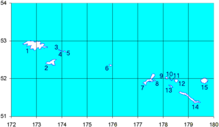
Map of the Western Aleutian Islands. Prepared from Digital Chart of the World (DCW) data. Latitudes are North, longitudes are East. The 52nd parallel is to scale.
1-5 - Near Islands
1 - Attu Island
2 - Agattu Island
3-5 - Semichi Islands
3 - Alaid Island
4 - Nizki Island
5 - Shemya Island
6 - Buldir Island
7-15 Rat Islands
7 - Kiska Island
8 - Little Kiska Island
9 - Segula Island
10 - Khvostof Island
11 - Davidof Island
12 - Little Sitkin Island
13 - Rat Island
14 - Amchitka Island
15 - Semisopochnoi Island
1-5 ニア諸島
1 - アッツ島
2 - アガッツ島
3-5 - セミチ諸島
3 - アライド島
4 - ニズキ島
5 - シェムリャ島
6 - ブルダー島
7-15 ラット諸島
7 - キスカ島
8 - 小キスカ島
9 - セグラ島
10 - クヴォストフ島
11 - ダヴィドフ島
12 - 小スィッキン島
13 - ラット島
14 - アムチトカ島
| Ik, de auteursrechthebbende van dit werk, geef dit werk vrij in het publieke domein. Dit is wereldwijd van toepassing. In sommige landen is dit wettelijk niet mogelijk; in die gevallen geldt: Ik sta iedereen toe dit werk voor eender welk doel te gebruiken, zonder enige voorwaarden, tenzij zulke voorwaarden door de wet worden voorgeschreven. |
Bestandsgeschiedenis
Klik op een datum/tijd om het bestand te zien zoals het destijds was.
| Datum/tijd | Miniatuur | Afmetingen | Gebruiker | Opmerking | |
|---|---|---|---|---|---|
| huidige versie | 19 sep 2008 17:12 | | 826 × 478 (10 kB) | Thingg | clarify number 10 and 11 |
| 4 aug 2005 21:58 |  | 826 × 478 (7 kB) | Urhixidur | Map of the Western Aleutian Islands. Prepared from Digital Chart of the World (DCW) data. Latitudes are North, longitudes are East. The 52nd parallel is to scale. 1-5 - Near Islands 1 - Attu Island 2 - Agattu Island 3-5 - Semichi Islands 3 - Alaid Island |
Bestandsgebruik
Dit bestand wordt op de volgende 10 pagina's gebruikt:
Globaal bestandsgebruik
De volgende andere wiki's gebruiken dit bestand:
- Gebruikt op arz.wikipedia.org
- Gebruikt op ast.wikipedia.org
- Gebruikt op az.wikipedia.org
- Gebruikt op ca.wikipedia.org
- Gebruikt op ceb.wikipedia.org
- Gebruikt op cs.wikipedia.org
- Gebruikt op de.wikipedia.org
- Gebruikt op en.wikipedia.org
Globaal gebruik van dit bestand bekijken.