
Bestand:Wpdms aq block 1614.jpg

Grootte van deze voorvertoning: 429 × 599 pixels. Andere resoluties: 172 × 240 pixels | 344 × 480 pixels | 550 × 768 pixels | 733 × 1.024 pixels | 1.466 × 2.048 pixels | 5.744 × 8.021 pixels.
Oorspronkelijk bestand (5.744 × 8.021 pixels, bestandsgrootte: 7,61 MB, MIME-type: image/jpeg)
| Dit is een bestand van Wikimedia Commons. Onderstaande beschrijving komt van de beschrijving van het bestand daar. |
Beschrijving
| Beschrijving |
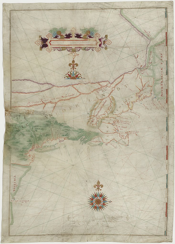
English: Map made by w:Adriaen Block of his 1614 expedition to North America. It is the first map to show Long Island as an island. It is also the first appearance of the term New Netherland to describe the colony (17th century drawing). |
|||||||||
| Datum | ||||||||||
| Bron | digitalized by the Dutch National Archive (perm link) | |||||||||
| Maker | ||||||||||
| Geotemporal data | ||||||||||
| Bounding box |
|
|||||||||
| Georeferencing | ||||||||||
| Andere versies | File:The figurative map of Adriaen Block (NYPL Hades-118535-54659).tif | |||||||||
Licentie
|
Het tweedimensionale kunstwerk afgebeeld op deze afbeelding valt in het publiek domein omdat:
Reproducties van het werk kunnen ook worden beschouwd als publiek domein omdat ze geen oorspronkelijk karakter hebben. Dit geldt voor reproducties gemaakt in de Verenigde Staten (zie Bridgeman Art Library v. Corel Corp.), Duitsland en veel andere landen.
| ||||
Bestandsgeschiedenis
Klik op een datum/tijd om het bestand te zien zoals het destijds was.
| Datum/tijd | Miniatuur | Afmetingen | Gebruiker | Opmerking | |
|---|---|---|---|---|---|
| huidige versie | 18 mei 2021 20:41 | | 5.744 × 8.021 (7,61 MB) | Ciell | Larger digitalisation from the Dutch National Archive |
| 17 feb 2012 19:15 |  | 456 × 640 (104 kB) | Gladiool | Better quality version of the same image. Found at [http://www.stonybrook.edu/libmap/coordinates/seriesa/no5/block.jpg]. | |
| 28 sep 2005 23:00 |  | 350 × 499 (31 kB) | Longbow4u | *Description:Map made by w:Adriaen Block of his 1614 expedition to North America. It is the first map to show Long Island as an island. It is also the first appearance of the term New Netherland to describe the colony (17th century drawing). *Sour |
Bestandsgebruik
Dit bestand wordt op de volgende 4 pagina's gebruikt:
Globaal bestandsgebruik
De volgende andere wiki's gebruiken dit bestand:
- Gebruikt op af.wikipedia.org
- Gebruikt op azb.wikipedia.org
- Gebruikt op be.wikipedia.org
- Gebruikt op ca.wikipedia.org
- Gebruikt op de.wikipedia.org
- Gebruikt op en.wikipedia.org
- Gebruikt op es.wikipedia.org
- Gebruikt op et.wikipedia.org
- Gebruikt op fa.wikipedia.org
- Gebruikt op fr.wikipedia.org
- Gebruikt op fy.wikipedia.org
- Gebruikt op hr.wikipedia.org
- Gebruikt op is.wikipedia.org
- Gebruikt op it.wikipedia.org
- Gebruikt op ja.wikipedia.org
- Gebruikt op ml.wikipedia.org
- Gebruikt op ru.wikipedia.org
- Gebruikt op sh.wikipedia.org
- Gebruikt op uk.wikipedia.org
- Gebruikt op zh.wikipedia.org