
Bestand:1864 Johnson Chart of the Flags and National Emblems of the World - Geographicus - Flags-johnson-1864.jpg

Grootte van deze voorvertoning: 800 × 590 pixels. Andere resoluties: 320 × 236 pixels | 640 × 472 pixels | 1.024 × 756 pixels | 1.280 × 945 pixels | 2.560 × 1.889 pixels | 4.000 × 2.952 pixels.
Oorspronkelijk bestand (4.000 × 2.952 pixels, bestandsgrootte: 3,25 MB, MIME-type: image/jpeg)
| Dit is een bestand van Wikimedia Commons. Onderstaande beschrijving komt van de beschrijving van het bestand daar. |
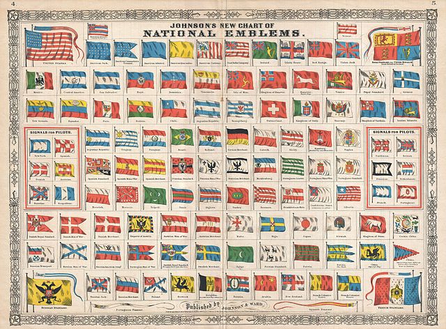
| Alvin Jewett Johnson: Johnson's New Chart of National Emblems.
( |
|||||||||||||||||||||||
|---|---|---|---|---|---|---|---|---|---|---|---|---|---|---|---|---|---|---|---|---|---|---|---|
| Kunstenaar |
|
||||||||||||||||||||||
| Titel |
Johnson's New Chart of National Emblems. |
||||||||||||||||||||||
| Beschrijving |
English: A beautiful first edition example of A. J. Johnson’s highly decorative 1864 chart of the world’s flags and national emblems. Johnson first introduced this chart in 1863 edition of his atlas. Though common in European, particularly English atlases, Johnson was the first American mapmaker to draw a national emblems or flag chart. Such charts were practical in port cities like New York, Boston, and London where military and merchant ships from around the world would often dock. Though initially a Richmond firm, Johnson & co. was quick to recognize the tide of war and smartly relocated business to New York City in 1861. Nonetheless, Johnson incorporates the “so called” flag of the Confederate States of American in the lower right quadrant. Subsequent examples of this chart delete the Confederate flag. Features the fretwork style border common to Johnson’s atlas work from 1864 to 1869. Published by A. J. Johnson and Ward as plates 4-5 in the 1864 edition of Johnson’s New Illustrated Family Atlas . This is the first edition of the Johnson’s Atlas to bear the Johnson & Ward imprint and the only edition to identify the firm as the “Successors to Johnson and Browning (Successors to J. H. Colton and Company)”. Dated and copyrighted, “Entered according to Act of Congress in the Year 1863 by A. J. Johnson in the Clerks Office of the District Court of the United States for the Southern District of New York. |
||||||||||||||||||||||
| Datum | 1864 (dated 1863) | ||||||||||||||||||||||
| Afmetingen | hoogte: 17,5 in (44,4 cm); breedte: 23,5 in (59,6 cm) | ||||||||||||||||||||||
| Inventarisnummer |
Geographicus link: Flags-johnson-1864 |
||||||||||||||||||||||
| Bron/fotograaf |
Johnson, A. J., Johnson's New Illustrated (Steel Plate) Family Atlas of The World with Physical Geography, and with Descriptions Geographical, Statistical, and Historic including The Latest Federal Census, A Geographical Index, and a Chronological History of the Civil War in America, (first Johnson and Ward), 1864.
|
||||||||||||||||||||||
| Toestemming (Hergebruik van dit bestand) |
|
||||||||||||||||||||||
| Andere versies |
 |
||||||||||||||||||||||
Bestandsgeschiedenis
Klik op een datum/tijd om het bestand te zien zoals het destijds was.
| Datum/tijd | Miniatuur | Afmetingen | Gebruiker | Opmerking | |
|---|---|---|---|---|---|
| huidige versie | 25 mrt 2011 03:22 | | 4.000 × 2.952 (3,25 MB) | BotMultichillT | {{subst:User:Multichill/Geographicus |link=http://www.geographicus.com/P/AntiqueMap/Flags-johnson-1864 |product_name=1864 Johnson Chart of the Flags and National Emblems of the World |map_title=Johnson's New Chart of National Emblems. |description=A beaut |
Bestandsgebruik
Dit bestand wordt op de volgende 3 pagina's gebruikt:
Globaal bestandsgebruik
De volgende andere wiki's gebruiken dit bestand:
- Gebruikt op als.wikipedia.org