
Bestand:Abies grandis range.JPG

Grootte van deze voorvertoning: 451 × 599 pixels. Andere resoluties: 180 × 240 pixels | 535 × 711 pixels.
Oorspronkelijk bestand (535 × 711 pixels, bestandsgrootte: 67 kB, MIME-type: image/jpeg)
| Dit is een bestand van Wikimedia Commons. Onderstaande beschrijving komt van de beschrijving van het bestand daar. |

|
Dit bestand kan vervangen worden door File:Abies grandis range map 0.png. Het wordt aangeraden om het andere bestand te gebruiken. Opmerking: dit bestand zal niet worden verwijderd tenzij het expliciet wordt genomineerd ter verwijdering. empty
|

|
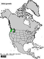
| Beschrijving | Range map of Grand Fir (Abies grandis) | |||
| Datum | ||||
| Bron | Digital representation of "Atlas of United States Trees" by Elbert L. Little, Jr. [1] | |||
| Auteur | U.S. Geological Survey | |||
| Toestemming (Hergebruik van dit bestand) |
|
Bestandsgeschiedenis
Klik op een datum/tijd om het bestand te zien zoals het destijds was.
| Datum/tijd | Miniatuur | Afmetingen | Gebruiker | Opmerking | |
|---|---|---|---|---|---|
| huidige versie | 23 jun 2006 14:21 | | 535 × 711 (67 kB) | Schzmo | {{Information |Description=Range map of Grand Fir (''Abies grandis'') |Source=Digital representation of "Atlas of United States Trees" by Elbert L. Little, Jr. [http://esp.cr.usgs.gov/data/atlas/little/] |Date=1999 |Author=U.S. Geological Survey |Permissi |
Bestandsgebruik
Geen enkele pagina gebruikt dit bestand.