
Bestand:Ancre sector 1 July 1916.png
Oorspronkelijk bestand (990 × 1.240 pixels, bestandsgrootte: 298 kB, MIME-type: image/png)
| Dit is een bestand van Wikimedia Commons. Onderstaande beschrijving komt van de beschrijving van het bestand daar. |
| Beschrijving |
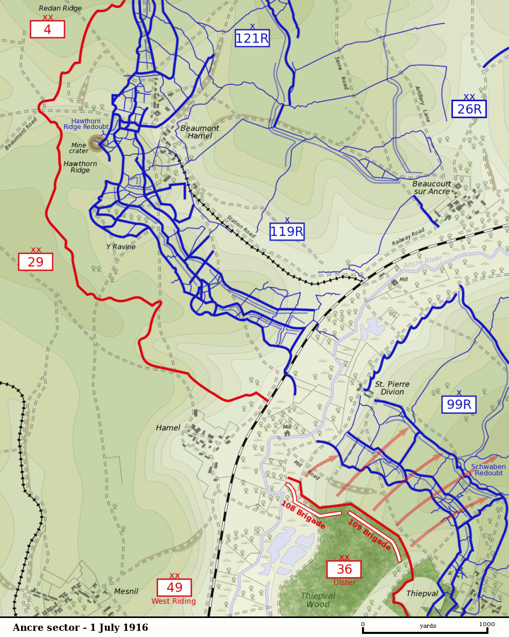
Map of the Ancre River sector of the Somme battlefield on the first day of the Battle of the Somme, 1 July 1916. British front line is shown in red. German trenches are shown in blue. German barbed wire is shown as dotted blue lines. The British divisions attacking on this sector were the British 29th Division at Beaumont Hamel and the 36th (Ulster) Division between the Ancre and Thiepval. The British 4th Division was attacking to the north towards Serre. The British 49th (West Riding) Division was in reserve. The sector was defended by the German 26th Reserve Division which had three regiments - 99th Reserve, 119th Reserve and 121st Reserve - in the front-line. The progress of the British 109th Brigade which captured the Schwaben Redoubt is shown. |
| Datum | |
| Bron |
Own Work by Gsl. Based on a British Ordnance Survey 1916 map (trenches as of 28 April 1916) held by the Liddle Collection. Units based on Map 9, The First Day on the Somme, Martin Middlebrook, 1971 and The Somme, Gary Sheffield, 2003. Originally uploaded to EN Wikipedia 21 November 2004 |
| Auteur | Gsl |
| Dit werk vrijgegeven in het publieke domein door de auteur, Gsl op de Engelstalige Wikipedia. Dit is wereldwijd van toepassing. In sommige landen is dit wettelijk niet mogelijk; in die gevallen geldt: Gsl staat iedereen toe dit werk voor eender welk doel te gebruiken, zonder enige voorwaarden, tenzij zulke voorwaarden door de wet worden voorgeschreven. |
Bestandsgeschiedenis
Klik op een datum/tijd om het bestand te zien zoals het destijds was.
| Datum/tijd | Miniatuur | Afmetingen | Gebruiker | Opmerking | |
|---|---|---|---|---|---|
| huidige versie | 11 nov 2007 04:59 | | 990 × 1.240 (298 kB) | Rcbutcher | {{Information |Description=Map of the Ancre River sector of the Somme battlefield on the first day of the Battle of the Somme, 1 July 1916. British front line is shown in red. German trenches are shown in blue. German |
Bestandsgebruik
Dit bestand wordt op de volgende pagina gebruikt:
Globaal bestandsgebruik
De volgende andere wiki's gebruiken dit bestand:
- Gebruikt op de.wikipedia.org
- Gebruikt op en.wikipedia.org
- Gebruikt op fr.wikipedia.org
- Gebruikt op pcd.wikipedia.org
- Gebruikt op www.wikidata.org