
Bestand:British main lines railway diagram.png

Grootte van deze voorvertoning: 421 × 599 pixels. Andere resoluties: 168 × 240 pixels | 337 × 480 pixels | 539 × 768 pixels | 719 × 1.024 pixels | 2.464 × 3.508 pixels.
Oorspronkelijk bestand (2.464 × 3.508 pixels, bestandsgrootte: 558 kB, MIME-type: image/png)
| Dit is een bestand van Wikimedia Commons. Onderstaande beschrijving komt van de beschrijving van het bestand daar. |

|
Bestand:British main lines railway diagram.svg is een vectorversie van dit bestand. Indien niet van slechtere kwaliteit dient deze gebruikt te worden in plaats van deze rasterafbeelding.
File:British main lines railway diagram.png → File:British main lines railway diagram.svg
Zie Help:SVG voor meer informatie. |
 |
Beschrijving
| Beschrijving |
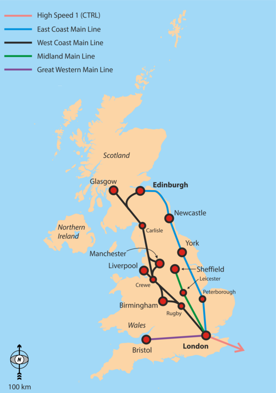
English: Simple overview map of the WCML, ECML, Midland Main Line and CTRL. |
| Datum | |
| Bron | Eigen werk |
| Auteur | Classical geographer |
Background is File:Uk_outline_map.png; ECML and WCML are based on File:Uk outline map with ECML railway.PNG and File:Uk outline map with WCML railway.PNG.
Licentie
Ik, de auteursrechthebbende van dit werk, maak het hierbij onder de volgende licentie beschikbaar:
Dit bestand is gelicenseerd onder de Creative Commons-licentie Naamsvermelding-Gelijk delen 3.0 Unported
- De gebruiker mag:
- Delen – het werk kopiëren, verspreiden en doorgeven
- Remixen – afgeleide werken maken
- Onder de volgende voorwaarden:
- naamsvermelding – U moet op een gepaste manier aan naamsvermelding doen, een link naar de licentie geven, en aangeven of er wijzigingen in het werk zijn aangebracht. U mag dit op elke redelijke manier doen, maar niet zodanig dat de indruk wordt gewekt dat de licentiegever instemt met uw werk of uw gebruik van zijn werk.
- Gelijk delen – Als u het werk heeft geremixt, veranderd, of erop heeft voortgebouwd, moet u het gewijzigde materiaal verspreiden onder dezelfde licentie als het oorspronkelijke werk, of een daarmee compatibele licentie.
Bestandsgeschiedenis
Klik op een datum/tijd om het bestand te zien zoals het destijds was.
| Datum/tijd | Miniatuur | Afmetingen | Gebruiker | Opmerking | |
|---|---|---|---|---|---|
| huidige versie | 6 sep 2016 19:29 | | 2.464 × 3.508 (558 kB) | Rob984 | Showing all of Ireland but not even part of France is odd. Especially considering there are UK-France high speed routes. |
| 6 sep 2016 06:48 |  | 2.503 × 3.627 (849 kB) | Classical geographer | Added Western Main Line. Decreased font size of junctions. Note the map is still intended for a quick overview, perhaps at the top of an article. | |
| 22 jul 2010 09:29 |  | 1.333 × 1.777 (188 kB) | Classical geographer | Chester should have been Crewe. | |
| 21 jul 2010 21:17 |  | 1.666 × 2.221 (904 kB) | Classical geographer | Resized, because was over 12.5 million pixels. | |
| 21 jul 2010 21:15 |  | 3.333 × 4.444 (600 kB) | Classical geographer | {{Information |Description={{en|1=Simple overview map of the WCML, ECML, Midland Main Line and CTRL.}} |Source={{own}} |Author=Classical geographer |Date=2010-07-21 |Permission= |other_versions= }} Background is [[:File:Uk_ou |
Bestandsgebruik
Dit bestand wordt op de volgende pagina gebruikt:
Globaal bestandsgebruik
De volgende andere wiki's gebruiken dit bestand:
- Gebruikt op en.wikipedia.org
- Gebruikt op fa.wikipedia.org
- Gebruikt op it.wikipedia.org
- Gebruikt op ja.wikipedia.org
- Gebruikt op no.wikipedia.org
- Gebruikt op pnb.wikipedia.org
- Gebruikt op pt.wikipedia.org
- Gebruikt op ru.wikipedia.org
- Gebruikt op ur.wikipedia.org
- Gebruikt op zh.wikipedia.org