
Bestand:Densidades de población en España (2005).svg

Afmetingen van deze voorvertoning van het type PNG van dit SVG-bestand: 568 × 387 pixels Andere resoluties: 320 × 218 pixels | 640 × 436 pixels | 1.024 × 698 pixels | 1.280 × 872 pixels | 2.560 × 1.744 pixels.
Oorspronkelijk bestand (SVG-bestand, nominaal 568 × 387 pixels, bestandsgrootte: 1,49 MB)
| Dit is een bestand van Wikimedia Commons. Onderstaande beschrijving komt van de beschrijving van het bestand daar. |
.svg)
Beschrijving
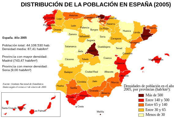
| Beschrijving | Mapa de España con las densidades de población por provincias, según el censo del Instituto Nacional de Estadística a 1 de enero de 2005. |
| Datum | |
| Bron | Instituto Nacional de Estadística de España [1]. |
| Auteur | Creado por Rodriguillo, tomando como mapa base Image:Provinces of Spain.svg, creado por Emilio Gómez Fernández |
| Andere versies | Image:Densidades de población en España (2005).png |
.png)
| Dit werk vrijgegeven in het publieke domein door de auteur, Rodriguillo. Dit is wereldwijd van toepassing. In sommige landen is dit wettelijk niet mogelijk; in die gevallen geldt: |
Bestandsgeschiedenis
Klik op een datum/tijd om het bestand te zien zoals het destijds was.
| Datum/tijd | Miniatuur | Afmetingen | Gebruiker | Opmerking | |
|---|---|---|---|---|---|
| huidige versie | 2 feb 2008 15:18 | | 568 × 387 (1,49 MB) | Rodriguillo | {{Information |Description= |Source= |Date= |Author= |Permission= |other_versions= }} |
| 2 feb 2008 15:08 |  | 568 × 387 (1,49 MB) | Rodriguillo | Corrijo fallo en la densidad de población de Álava + cambio frontera rojo/naranja a los 140 hab/km2 | |
| 31 jul 2007 15:18 |  | 568 × 387 (1,49 MB) | Rodriguillo | ||
| 31 jul 2007 15:13 |  | 568 × 387 (1,49 MB) | Rodriguillo | == Summary == {{Information |Description= Mapa de España con las '''densidades de población''' por provincias, según el censo del Instituto Nacional de Estadística a 1 de enero de 2005. |Source= Instituto Nacional de Estadística de España [http |
Bestandsgebruik
Dit bestand wordt op de volgende pagina gebruikt:
Globaal bestandsgebruik
De volgende andere wiki's gebruiken dit bestand:
- Gebruikt op es.wikipedia.org
- Gebruikt op fr.wikipedia.org
.svg)