
Bestand:East African oryx Oryx beisa distribution map 2.png

Grootte van deze voorvertoning: 383 × 599 pixels. Andere resoluties: 153 × 240 pixels | 568 × 889 pixels.
Oorspronkelijk bestand (568 × 889 pixels, bestandsgrootte: 739 kB, MIME-type: image/png)
| Dit is een bestand van Wikimedia Commons. Onderstaande beschrijving komt van de beschrijving van het bestand daar. |
Beschrijving
| Beschrijving |
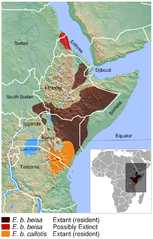
English: Geographical distribution of the East African oryx Oryx beisa. The map was created using the Generic Mapping Tools, GMT, version 5.1.2. |
| Datum | |
| Bron |
Own work using:
|
| Auteur | Darekk2 using the IUCN Red List spatial data and GLOBE grids |
Licentie
Attribution: The author of the work and
- the IUCN Red List spatial data.
IUCN (International Union for Conservation of Nature) 2008. Oryx beisa. In: IUCN 2015. The IUCN Red List of Threatened Species. Version 2015.2. http://www.iucnredlist.org. Downloaded on 14 July 2015. - GLOBE grids
(for credits see the Source section)
The NGDC in it's copyright notice says:
As required by 17 U.S.C. 403, third parties producing copyrighted works consisting predominantly of the material produced by U.S. government agencies must provide notice with such work(s) identifying the U.S. Government material incorporated and stating that such material is not subject to copyright protection within the United States. (...).
Dit bestand is gelicenseerd onder de Creative Commons Naamsvermelding-GelijkDelen 4.0 Internationaal licentie.
Naamsvermelding: The author of the work
and the IUCN Red List spatial data
and GLOBE
(see above and the Source section)
and the IUCN Red List spatial data
and GLOBE
(see above and the Source section)
- De gebruiker mag:
- Delen – het werk kopiëren, verspreiden en doorgeven
- Remixen – afgeleide werken maken
- Onder de volgende voorwaarden:
- naamsvermelding – U moet op een gepaste manier aan naamsvermelding doen, een link naar de licentie geven, en aangeven of er wijzigingen in het werk zijn aangebracht. U mag dit op elke redelijke manier doen, maar niet zodanig dat de indruk wordt gewekt dat de licentiegever instemt met uw werk of uw gebruik van zijn werk.
- Gelijk delen – Als u het werk heeft geremixt, veranderd, of erop heeft voortgebouwd, moet u het gewijzigde materiaal verspreiden onder dezelfde licentie als het oorspronkelijke werk, of een daarmee compatibele licentie.
Bestandsgeschiedenis
Klik op een datum/tijd om het bestand te zien zoals het destijds was.
| Datum/tijd | Miniatuur | Afmetingen | Gebruiker | Opmerking | |
|---|---|---|---|---|---|
| huidige versie | 20 jun 2016 01:18 | | 568 × 889 (739 kB) | Darekk2 | added border between Sudans |
| 15 jul 2015 19:07 |  | 568 × 889 (738 kB) | Darekk2 | thinner borders in the inset map | |
| 15 jul 2015 18:51 |  | 568 × 889 (739 kB) | Darekk2 | thinner borders in the inset map | |
| 15 jul 2015 17:11 |  | 568 × 889 (739 kB) | Darekk2 | latin names to oblique (italics) | |
| 15 jul 2015 16:44 |  | 568 × 889 (738 kB) | Darekk2 | User created page with UploadWizard |
Bestandsgebruik
Dit bestand wordt op de volgende pagina gebruikt:
Globaal bestandsgebruik
De volgende andere wiki's gebruiken dit bestand:
- Gebruikt op en.wikipedia.org
- Gebruikt op es.wikipedia.org
- Gebruikt op hu.wikipedia.org
- Gebruikt op it.wikipedia.org
- Gebruikt op ka.wikipedia.org
- Gebruikt op ko.wikipedia.org
- Gebruikt op pl.wikipedia.org
- Gebruikt op ru.wikipedia.org
- Gebruikt op sco.wikipedia.org
- Gebruikt op sr.wikipedia.org
- Gebruikt op vi.wikipedia.org