
Bestand:Ghajar highlighted.JPG
Grootte van deze voorvertoning: 517 × 599 pixels. Andere resoluties: 207 × 240 pixels | 414 × 480 pixels | 742 × 860 pixels.
Oorspronkelijk bestand (742 × 860 pixels, bestandsgrootte: 108 kB, MIME-type: image/jpeg)
| Dit is een bestand van Wikimedia Commons. Onderstaande beschrijving komt van de beschrijving van het bestand daar. |
| Beschrijving |
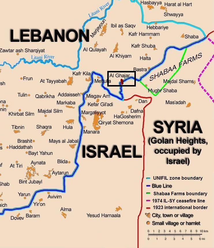
English: Map showing the Blue Line demarcation line between Lebanon and Israel, established by the UN after the Israeli withdrawal from southern Lebanon after its short 1978 invasion called "Operation Litani". It follows the 1949 cease-fire line, also known as the Green Line, as well as the somewhat contested Lebanese-Syrian border towards the Israeli-occupied Golan Heights. The map is made by Thomas Blomberg, using the UNIFIL map, deployment as of July 2006 as source. Español: Sumario. Mapa mostrando a la línea de demarcación de Línea Azul entre Líbano y Israel, establecido por las Naciones Unidas después de la retirada israelí de Líbano del sur después de su invasión de 1978 corta llamada " Operación Litani ". Esto sigue la línea de alto el fuego 1949, también sabida(conocida) como la Línea Verde, así como la frontera algo impugnada libanesa siria hacia Altos del Golán Ocupados por israelí. El mapa es hecho por Thomas Blomberg, usando el mapa de UNIFIL, el despliegue desde el julio de 2006 como la fuente |
| Datum | (UTC) |
| Bron | |
| Auteur |
|
| Dit is een geretoucheerde foto, wat betekent dat de originele versie digitaal aangepast is. Aanpassingen: zoom, highlight Ghajar. Het origineel kan hier bekeken worden: BlueLine.jpg. Aanpassingen gedaan door Nableezy.
|
Ik, de auteursrechthebbende van dit werk, maak het hierbij onder de volgende licentie beschikbaar:
Dit bestand is gelicenseerd onder de Creative Commons-licentie Naamsvermelding-Gelijk delen 2.5 Unported
- De gebruiker mag:
- Delen – het werk kopiëren, verspreiden en doorgeven
- Remixen – afgeleide werken maken
- Onder de volgende voorwaarden:
- naamsvermelding – U moet op een gepaste manier aan naamsvermelding doen, een link naar de licentie geven, en aangeven of er wijzigingen in het werk zijn aangebracht. U mag dit op elke redelijke manier doen, maar niet zodanig dat de indruk wordt gewekt dat de licentiegever instemt met uw werk of uw gebruik van zijn werk.
- Gelijk delen – Als u het werk heeft geremixt, veranderd, of erop heeft voortgebouwd, moet u het gewijzigde materiaal verspreiden onder dezelfde licentie als het oorspronkelijke werk, of een daarmee compatibele licentie.
Oorspronkelijk uploadlogboek
This image is a derivative work of the following images:
- File:BlueLine.jpg licensed with Cc-by-sa-2.5
- 2010-02-15T10:27:00Z Ynhockey 1299x898 (160308 Bytes) Boundery?[sic] Anyway, this is the international border. If you want to draw the DMZ, make an extra line, but please do it with an app other than MSPaint
- 2008-08-10T03:01:31Z Drork 1299x898 (160308 Bytes) == Summary == Map showing the [[Blue Line (Lebanon)|Blue Line]] demarcation line between [[Lebanon]] and [[Israel]], established by the [[United Nations|UN]] after the Israeli withdrawal from southern Lebanon after its short
- 2006-08-17T16:30:36Z Thomas Blomberg 1299x898 (244059 Bytes)
- 2006-08-04T14:16:01Z Thomas Blomberg 1299x898 (658281 Bytes) Map showing the Blue Line demarkation line between Lebanon and Israel, established by the UN after the Israeli withdrawal from southern Lebanon after its short 1978 invasion called "Operation Litani". It follows the 1949 ceas
Uploaded with derivativeFX
Bestandsgeschiedenis
Klik op een datum/tijd om het bestand te zien zoals het destijds was.
| Datum/tijd | Miniatuur | Afmetingen | Gebruiker | Opmerking | |
|---|---|---|---|---|---|
| huidige versie | 21 okt 2010 22:20 | | 742 × 860 (108 kB) | Nableezy | change map base, highlight color |
| 21 okt 2010 21:11 |  | 760 × 884 (110 kB) | Nableezy | change highlight color | |
| 21 okt 2010 19:59 |  | 809 × 868 (116 kB) | Nableezy | {{Information |Description={{en|Map showing the Blue Line demarcation line between Lebanon and Israel, established by the UN after the Israeli withdrawal from southern Lebanon after its short 1978 invas |
Bestandsgebruik
Dit bestand wordt op de volgende pagina gebruikt:
Globaal bestandsgebruik
De volgende andere wiki's gebruiken dit bestand:
- Gebruikt op ar.wikipedia.org
- Gebruikt op ca.wikipedia.org
- Gebruikt op de.wikipedia.org
- Gebruikt op eo.wikipedia.org
- Gebruikt op fi.wikipedia.org
- Gebruikt op fr.wikipedia.org
- Gebruikt op pl.wiktionary.org
- Gebruikt op www.wikidata.org