
Bestand:Kīlauea Iki, Hawaiʻi Volcanoes National Park, Hawaii (4528779141).jpg

Oorspronkelijk bestand (2.816 × 2.112 pixels, bestandsgrootte: 2,67 MB, MIME-type: image/jpeg)
| Dit is een bestand van Wikimedia Commons. Onderstaande beschrijving komt van de beschrijving van het bestand daar. |
.jpg)
Beschrijving
| Beschrijving |
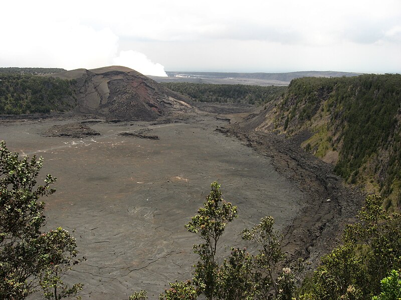
Kīlauea Iki is a pit crater which is next to the main summit caldera of Kīlauea. In August 1959, a swarm of deep earthquakes was detected by the Hawaiian Volcano Observatory. In October it was indicated by seismographs that Kilauea summit was filling with magma. This formed a new lava shield, named Pu'u Pua'i (gushing hill). Some of the most impressive parts of the eruption were the lava fountains that flowed from Puʻu Puaʻi. By November 17, the fountain was reaching 60–80 meters tall with occasional bursts as high as 180 meters. The fountain grew to over 320 meters on November 18. On November 21, the lava lake was over a meter deep over the vent causing ripples across the surface of the lava lake causing lava on the shores to break like waves on a beach. At 7:25 p.m. local time on November 21, the fountain went from 210 meters tall to a few gas bubbles in less than 40 seconds. Some of the fountains were extraordinarily high, reaching nearly 580 m (1,900 ft), among the highest ever recorded. The first episode had 31 million cubic meters of lava flow into Kīlauea Iki with 1 million cubic meters draining back. During the following episodes, a total of 71 million cubic meters of lava was ejected during a month long eruption that stopped on December 20, 1959. Only 8 million cubic meters of lava remained, 63 million cubic meters of lava drained back into Kīlauea magma reservoir. Often the lava drainback had a higher rate of flow than the eruptions. On December 15, the highest flow of lava was measured at 1.45 million cubic meters per hour. With every filling and draining of the lava lake, a 'black ledge' was formed along the rim of the crater which is now 15–60 meters wide and 15 meters tall. During lava drainbacks, a giant counter-clockwise whirlpool would form. Drivers may view Kīlauea Iki from either a lookout point or the trailhead parking lot. Currently guests can hike across Kīlauea Iki from Byron Ledge which overlooks the crater as well as walking along the crater floor on what once was a lake of lava. Even after 50 years, the surface is still warm to the touch. Rainwater seeps into the cracks and makes contact with the extremely hot rock below and steam is emitted from various surface cracks. The steam and some rocks are hot enough to cause serious burns. en.wikipedia.org/wiki/K%C4%ABlauea_Iki en.wikipedia.org/wiki/Wikipedia:Text_of_Creative_Commons_... |
| Datum | |
| Bron | Kīlauea Iki, Hawaiʻi Volcanoes National Park, Hawaii |
| Auteur | Ken Lund from Reno, Nevada, USA |
| Cameralocatie | | Deze en andere afbeeldingen in: OpenStreetMap |
|---|
.jpg¶ms=019.416456_N_-155.242996_E_globe:Earth_type:camera_source:Flickr_&language=nl)
Licentie
- De gebruiker mag:
- Delen – het werk kopiëren, verspreiden en doorgeven
- Remixen – afgeleide werken maken
- Onder de volgende voorwaarden:
- naamsvermelding – U moet op een gepaste manier aan naamsvermelding doen, een link naar de licentie geven, en aangeven of er wijzigingen in het werk zijn aangebracht. U mag dit op elke redelijke manier doen, maar niet zodanig dat de indruk wordt gewekt dat de licentiegever instemt met uw werk of uw gebruik van zijn werk.
- Gelijk delen – Als u het werk heeft geremixt, veranderd, of erop heeft voortgebouwd, moet u het gewijzigde materiaal verspreiden onder dezelfde licentie als het oorspronkelijke werk, of een daarmee compatibele licentie.
| Deze afbeelding is oorspronkelijk op Flickr geplaatst door Ken Lund op https://flickr.com/photos/75683070@N00/4528779141. Dit is op 9 januari 2017 door de FlickreviewR-Bot beoordeeld en de licentie onder de voorwaarden van cc-by-sa-2.0 is bevestigd. |
Bestandsgeschiedenis
Klik op een datum/tijd om het bestand te zien zoals het destijds was.
| Datum/tijd | Miniatuur | Afmetingen | Gebruiker | Opmerking | |
|---|---|---|---|---|---|
| huidige versie | 9 jan 2017 05:10 | | 2.816 × 2.112 (2,67 MB) | Holly Cheng | Transferred from Flickr via Flickr2Commons |
Bestandsgebruik
Dit bestand wordt op de volgende pagina gebruikt:
Globaal bestandsgebruik
De volgende andere wiki's gebruiken dit bestand:
- Gebruikt op ja.wikipedia.org
.jpg)