
Bestand:Landlocked countries.png
Grootte van deze voorvertoning: 800 × 351 pixels. Andere resoluties: 320 × 140 pixels | 640 × 281 pixels | 1.425 × 625 pixels.
Oorspronkelijk bestand (1.425 × 625 pixels, bestandsgrootte: 54 kB, MIME-type: image/png)
| Dit is een bestand van Wikimedia Commons. Onderstaande beschrijving komt van de beschrijving van het bestand daar. |

|
Bestand:Landlocked countries.svg is een vectorversie van dit bestand. Indien niet van slechtere kwaliteit dient deze gebruikt te worden in plaats van deze rasterafbeelding.
File:Landlocked countries.png → File:Landlocked countries.svg
Zie Help:SVG voor meer informatie. |
 |
Beschrijving
| Beschrijving | |
| Datum | |
| Bron | Eigen werk |
| Auteur | Ævar Arnfjörð Bjarmason |
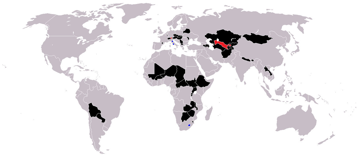
Countries coloured black on the map
Countries coloured red on the map (double landlocked)
Countries coloured blue on the map (landlocked by a single country)
Licentie
| Ik, de auteursrechthebbende van dit werk, geef dit werk vrij in het publieke domein. Dit is wereldwijd van toepassing. In sommige landen is dit wettelijk niet mogelijk; in die gevallen geldt: Ik sta iedereen toe dit werk voor eender welk doel te gebruiken, zonder enige voorwaarden, tenzij zulke voorwaarden door de wet worden voorgeschreven. |
Bestandsgeschiedenis
Klik op een datum/tijd om het bestand te zien zoals het destijds was.
| Datum/tijd | Miniatuur | Afmetingen | Gebruiker | Opmerking | |
|---|---|---|---|---|---|
| huidige versie | 1 jun 2018 14:36 | | 1.425 × 625 (54 kB) | LamBoet | Reverted to version as of 16:39, 15 July 2011 (UTC) - Restore blue color for countries that are landlocked by a single country |
| 2 apr 2018 23:34 |  | 1.425 × 625 (37 kB) | Maphobbyist | Check | |
| 2 apr 2018 23:03 |  | 1.425 × 625 (37 kB) | Maphobbyist | Black coloring for San Marino, Vatican and Lesotho. | |
| 15 jul 2011 18:39 |  | 1.425 × 625 (54 kB) | Hoshie | added South Sudan and added circles foe European microsates | |
| 27 sep 2010 15:47 |  | 1.425 × 625 (48 kB) | (지금은) 소년시대 | + Landlocked by a single country | |
| 23 okt 2008 07:33 |  | 1.425 × 625 (48 kB) | IngSoc BigBrother | ||
| 25 feb 2007 18:14 |  | 1.425 × 625 (30 kB) | Aivazovsky~commonswiki | ||
| 23 mei 2006 11:29 |  | 1.357 × 628 (46 kB) | Stefan040780 | source: same as old map, updated on 23.5.06 by stefan040780 | |
| 21 jun 2005 05:08 |  | 1.357 × 628 (25 kB) | Ævar Arnfjörð Bjarmason | Landlocked countries, based on Image:BlankMap-World.png. Category:World maps |
Bestandsgebruik
Geen enkele pagina gebruikt dit bestand.
Globaal bestandsgebruik
De volgende andere wiki's gebruiken dit bestand:
- Gebruikt op ckb.wikipedia.org
- Gebruikt op da.wikipedia.org
- Gebruikt op eu.wikipedia.org
- Gebruikt op fa.wikipedia.org
- Gebruikt op fo.wikipedia.org
- Gebruikt op fr.wikipedia.org
- Gebruikt op hr.wikipedia.org
- Gebruikt op hu.wikipedia.org
- Gebruikt op is.wiktionary.org
- Gebruikt op ja.wikipedia.org
- Gebruikt op ja.wiktionary.org
- Gebruikt op kk.wikipedia.org
- Gebruikt op ko.wikipedia.org
- Gebruikt op mk.wikipedia.org
- Gebruikt op ms.wikipedia.org
- Gebruikt op nso.wikipedia.org
- Gebruikt op te.wikipedia.org
- Gebruikt op uk.wikipedia.org
- Gebruikt op vi.wikipedia.org
- Gebruikt op zh-yue.wikipedia.org