
Bestand:Mapa tuberculose.png

Grootte van deze voorvertoning: 800 × 370 pixels. Andere resoluties: 320 × 148 pixels | 640 × 296 pixels | 1.357 × 628 pixels.
Oorspronkelijk bestand (1.357 × 628 pixels, bestandsgrootte: 34 kB, MIME-type: image/png)
| Dit is een bestand van Wikimedia Commons. Onderstaande beschrijving komt van de beschrijving van het bestand daar. |

|
Deze health map-afbeelding zou opnieuw moeten worden aangemaakt als een SVG-bestand door vectorafbeeldingen te gebruiken. Dit heeft een aantal voordelen; zie Commons:Media for cleanup voor meer informatie. Als er een SVG-formaat van deze afbeelding bestaat, dan deze graag uploaden. Nadat u dit heeft gedaan, gelieve dit sjabloon te vervangen door het sjabloon {{vector version available|nieuwe bestandsnaam.svg}} op deze afbeeldingspagina.
|
| Beschrijving |
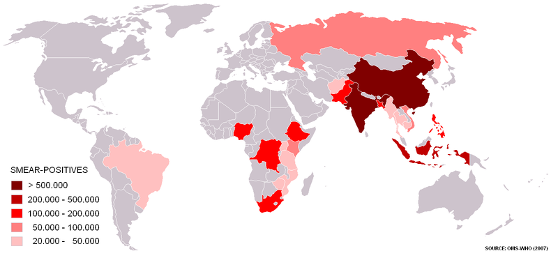
Português: Mapa dos países onde 80% dos casos de tuberculose estão concentrados. Fonte: Organização Mundial da Saúde. (Substituta para outra imagem de direitos autorais desconhecidos). Baseado em um mapa-múndi em branco disponibilizado aos usuários da Wikipédia.
Deutsch: Die Karte zeigt die 22 "Schwer betroffenen Laender" (high-burden countries), in denen circa 80% aller jaehrlichen neuen TB Faelle registriert werden. Stand 2007, Quelle: WHO Report 2009 - Globale Tuberkulose Kontrolle, Abbildung 1.2 "Estimiated epidemiological burden of TB in 2007"
English: Map of the 22 HBCs (high-burden countries) that account for approximately 80% of all new TB cases arising each year. Source: WHO Report 2009 - Global Tuberculosis Control, Table 1.2 "Estimated epidemiological burden of TB in 2007"
Русский: Плотность ежегодных выявлений новых случаев туберкулеза, 22 страны, что согласно ВОЗ составляет 80 % всех новых случаев заболевания туберкулезом. |
||||||||
| Datum | |||||||||
| Bron | WHO Report 2009 - Global Tuberculosis Control | ||||||||
| Auteur | OMS-WHO | ||||||||
| Toestemming (Hergebruik van dit bestand) |
|

Bestandsgeschiedenis
Klik op een datum/tijd om het bestand te zien zoals het destijds was.
| Datum/tijd | Miniatuur | Afmetingen | Gebruiker | Opmerking | |
|---|---|---|---|---|---|
| huidige versie | 25 apr 2010 19:56 | | 1.357 × 628 (34 kB) | Capmo | forgot to paint Sakhalin (Russia) and Hainan (PRC) |
| 21 apr 2010 03:42 |  | 1.357 × 628 (33 kB) | Capmo | Updated with data from WHO Report 2009 - Global Tuberculosis Control, Table 1.2 (Estimated epidemiological burden of TB, 2007) | |
| 14 aug 2006 16:19 |  | 679 × 314 (30 kB) | Jungpionier | islands of Indonesia, Philippines and Russia in red | |
| 21 dec 2005 20:20 |  | 679 × 314 (30 kB) | Santana-freitas~commonswiki | Mapa dos países onde 80% dos casos de tuberculose estão concentrados. Fonte: Organização Mundial da Saúde. (Substituta para outra imagem de direitos autorais desconhecidos) Baseado em um mapa-múndi em branco disponibilizado aos usuários da |
Bestandsgebruik
Dit bestand wordt op de volgende pagina gebruikt:
Globaal bestandsgebruik
De volgende andere wiki's gebruiken dit bestand:
- Gebruikt op als.wikipedia.org
- Gebruikt op ay.wikipedia.org
- Gebruikt op be-tarask.wikipedia.org
- Gebruikt op be.wikipedia.org
- Gebruikt op cs.wikipedia.org
- Gebruikt op de.wikibooks.org
- Gebruikt op de.wikinews.org
- Gebruikt op fy.wikipedia.org
- Gebruikt op gl.wikipedia.org
- Gebruikt op ko.wikipedia.org
- Gebruikt op ku.wikipedia.org
- Gebruikt op pt.wikipedia.org
- Gebruikt op qu.wikipedia.org
- Gebruikt op uk.wikipedia.org