
Bestand:Norad map.png
Geen hogere resolutie beschikbaar.
Norad_map.png (702 × 326 pixels, bestandsgrootte: 55 kB, MIME-type: image/png)
| Dit is een bestand van Wikimedia Commons. Onderstaande beschrijving komt van de beschrijving van het bestand daar. |
| Beschrijving |
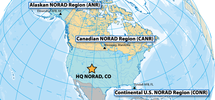
Français : La zone opérationnelle du NORAD est divisée en trois régions. L'Alaskan Norad Region, le Canadian Norad et le Continental U.S Norad. |
||||||
| Datum | Datum onbekend | ||||||
| Bron | http://www.noradsanta.org/fr/anorad.html | ||||||
| Auteur | Onbekend | ||||||
| Toestemming (Hergebruik van dit bestand) |
|
||||||

Bestandsgeschiedenis
Klik op een datum/tijd om het bestand te zien zoals het destijds was.
| Datum/tijd | Miniatuur | Afmetingen | Gebruiker | Opmerking | |
|---|---|---|---|---|---|
| huidige versie | 17 okt 2010 08:40 | | 702 × 326 (55 kB) | L'amateur d'aéroplanes | {{Information |Description={{fr|1=La zone opérationnelle du NORAD est divisée en trois régions. L'Alaskan Norad Region, le Canadian Norad et le Continental U.S Norad. }} |Source=http://www.noradsanta.org/fr/anorad.html |Author=Inconnu |Date=Inconnu |P |
Bestandsgebruik
Dit bestand wordt op de volgende pagina gebruikt:
Globaal bestandsgebruik
De volgende andere wiki's gebruiken dit bestand:
- Gebruikt op ca.wikipedia.org
- Gebruikt op de.wikipedia.org
- Gebruikt op es.wikipedia.org
- Gebruikt op fi.wikipedia.org
- Gebruikt op fr.wikipedia.org
- Gebruikt op it.wikipedia.org
- Gebruikt op pl.wikipedia.org
- Gebruikt op ro.wikipedia.org
- Gebruikt op vi.wikipedia.org