
Bestand:Stad Amsterdam in Nieuw Nederland (City Amsterdam in New Netherland) Castello Plan 1660.jpg

Grootte van deze voorvertoning: 800 × 600 pixels. Andere resoluties: 320 × 240 pixels | 640 × 480 pixels | 1.024 × 768 pixels | 1.280 × 960 pixels | 2.560 × 1.920 pixels | 3.888 × 2.916 pixels.
Oorspronkelijk bestand (3.888 × 2.916 pixels, bestandsgrootte: 4,28 MB, MIME-type: image/jpeg)
| Dit is een bestand van Wikimedia Commons. Onderstaande beschrijving komt van de beschrijving van het bestand daar. |
_Castello_Plan_1660.jpg)
Beschrijving
| Beschrijving |
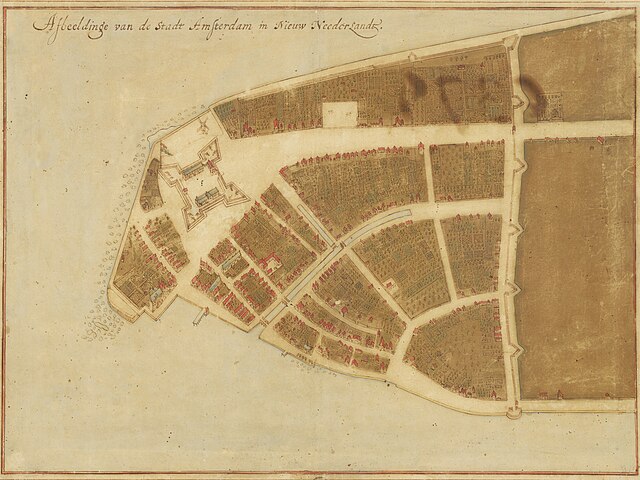
English: Map of New Amsterdam in New Netherland (Manhattan), 1660. Title: "Afbeeldinge van de Stadt Amsterdam in Nieuw Neederlandt." Made by Johannes Vingboons (1616-1670), a cartographer of the VOC. Based on surveys by Jacques Cortelyou (1625–1693). The Grand Duke of Tuscany, Cosimo III de’ Medici (1642-1723), travelled to Amsterdam, the Netherlands in 1667. He was fascinated by Vingboons' work and bought watercolor paintings with mediation by Pieter Blaeu (1637-1706). The paintings were exhibited in his Florentine Villa di Castello.[1] |
| Datum | |
| Bron | New York Historical Society - https://www.nyhistory.org/exhibitions/new-york-before-new-york-the-castello-plan . Image url: https://web.archive.org/web/20240212181141/https://images.prismic.io/nyhs-prod/3016cf7a-44f1-484c-9de7-53facb6ab21a_Carte+di+Castello+18.jpg The map (Carte di Castello 18) is at Biblioteca Medicea Laurenziana, Florence. |
| Auteur | Johannes Vingboons (cartographer), Jacques Cortelyou (surveyor) |
| Andere versies |
 |
Licentie
|
Dit werk bevindt zich in het publiek domein in landen en gebieden waar de auteursrechttermijn het leven van de auteur plus 100 jaar of minder is. | |
| Van dit bestand is vastgesteld dat er geen bekende auteursrechtaanspraken op rusten, alle aanverwante en naburige rechten daarbij inbegrepen. | |
- ↑ De ontdekking van de wereld. University of Groningen Library (October 2, 2019). Archived from the original on June 29, 2022.
Bestandsgeschiedenis
Klik op een datum/tijd om het bestand te zien zoals het destijds was.
| Datum/tijd | Miniatuur | Afmetingen | Gebruiker | Opmerking | |
|---|---|---|---|---|---|
| huidige versie | 13 apr 2024 05:34 | | 3.888 × 2.916 (4,28 MB) | User-duck | Cropped borders to center using CropTool with lossless mode. |
| 12 feb 2024 20:52 |  | 4.000 × 3.070 (4,54 MB) | Artanisen | Corrected brightness and contrast | |
| 12 feb 2024 18:59 |  | 4.000 × 3.070 (4,2 MB) | Artanisen | Uploaded a work by Johannes Vingboons (VOC-cartographer), Jacques Cortelyou (surveyor) from New York Historical Society - https://www.nyhistory.org/exhibitions/new-york-before-new-york-the-castello-plan . Image url: https://images.prismic.io/nyhs-prod/3016cf7a-44f1-484c-9de7-53facb6ab21a_Carte+di+Castello+18.jpg with UploadWizard |
Bestandsgebruik
Dit bestand wordt op de volgende 3 pagina's gebruikt:
Globaal bestandsgebruik
De volgende andere wiki's gebruiken dit bestand:
- Gebruikt op arz.wikipedia.org
- Gebruikt op de.wikipedia.org
- Gebruikt op en.wikipedia.org
- New Amsterdam
- Peter Stuyvesant
- Wall Street
- Manhattan
- Financial District, Manhattan
- New York City
- Whitehall Street
- List of cities with defensive walls
- Castello Plan
- Jacques Cortelyou
- List of coastal fortifications of the United States
- New Netherland settlements
- Jan Everts Bout
- Harbor Defenses of New York
- Manhattoe
- Cartography of New York City
- History of Manhattan
- Gebruikt op en.wikivoyage.org
- Gebruikt op es.wikipedia.org
- Gebruikt op fi.wikipedia.org
- Gebruikt op fr.wikipedia.org
- Gebruikt op gu.wikipedia.org
- Gebruikt op gv.wikipedia.org
- Gebruikt op he.wikipedia.org
- Gebruikt op hi.wikipedia.org
- Gebruikt op hu.wikipedia.org
- Gebruikt op hy.wikipedia.org
- Gebruikt op id.wikipedia.org
- Gebruikt op it.wikipedia.org
- Gebruikt op ja.wikipedia.org
- Gebruikt op kn.wikipedia.org
Globaal gebruik van dit bestand bekijken.
_Castello_Plan_1660.jpg)
_Castello_Plan_1660.jpg)