
Bestand:Volcanoes near Usulután, El Salvador.jpg

Grootte van deze voorvertoning: 687 × 600 pixels. Andere resoluties: 275 × 240 pixels | 550 × 480 pixels | 880 × 768 pixels | 1.173 × 1.024 pixels | 2.346 × 2.048 pixels | 4.037 × 3.525 pixels.
Oorspronkelijk bestand (4.037 × 3.525 pixels, bestandsgrootte: 6,59 MB, MIME-type: image/jpeg)
| Dit is een bestand van Wikimedia Commons. Onderstaande beschrijving komt van de beschrijving van het bestand daar. |
Beschrijving
| Beschrijving |
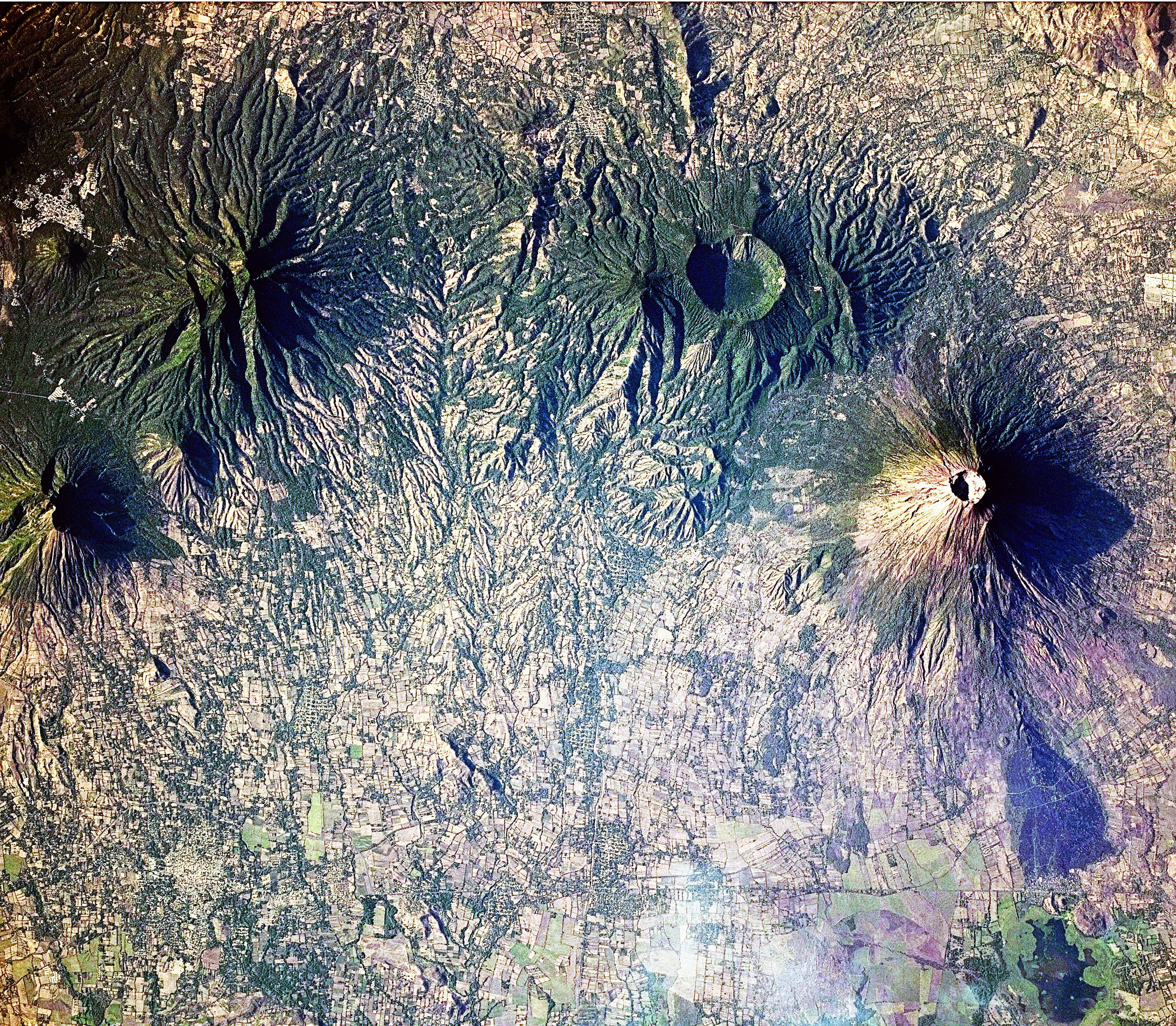
English: This astronaut photograph includes four stratovolcanoes—a type of volcano common in active subduction zones—in El Salvador, near the midpoint of the Central American Volcanic Arc. While all of the volcanoes shown here have been active during the Holocene Epoch (from about 10,000 years ago to the present), only the 2,130-meter high San Miguel (also known as Chaparrastique) has been active during historical times. The most recent activity of San Miguel was a minor gas and ash emission in 2013. The stratovolcano’s steep cone shape and well-developed summit crater are evident, along with dark lava flows. Immediately to the north-west, the truncated summit of Chinameca Volcano (also known as El Pacayal) is marked by a two-kilometre wide caldera. The caldera formed when a powerful eruption emptied the volcano’s magma chamber, causing the chamber’s roof to collapse. Like its neighbour San Miguel, Chinameca’s slopes host coffee plantations. Moving to the west, the eroded cone of El Tigre Volcano is visible. El Tigre formed during the Pleistocene Epoch (1.8 million to about 10,000 years ago), and it is likely the oldest of the stratovolcanoes in the image. Usulután Volcano is directly south-west of El Tigre. While the flanks of Usulután have been dissected by streams, the mountain still retains a summit crater that is breached on the eastern side. Several urban areas—recognizable as light grey to white regions contrasting with green vegetation and tan fallow agricultural fields—are located in the vicinity of these volcanoes, including the town of Usulután (lower left) and Santiago de María (upper left). |
| Datum | |
| Bron | NASA Earth Observatory |
| Auteur | NASA Expedition 23 crew |
| Cameralocatie | | Deze en andere afbeeldingen in: OpenStreetMap |
|---|
Deze afbeelding of video is gecatalogiseerd door Johnson Space Center van de Verenigde Staten National Aeronautics and Space Administration (NASA)onder Foto ID: ISS023-E-22411.Deze banner zegt niets over de auteursrechten die van toepassing zijn. Een normale auteursrechten-tag is nodig. Zie Commons:Licensing voor meer informatie. Andere talen:
|
Image acquired with a Nikon D3X digital camera fitted with an effective 340 mm lens, and is provided by the ISS Crew Earth Observations experiment and Image Science & Analysis Laboratory, Johnson Space Center.
Licentie
| Dit bestand bevindt zich in het publiek domein, omdat het gemaakt is door de NASA. In de reproductierichtlijnen van de NASA staat dat "NASA-materiaal niet beschermd wordt door auteursrecht, tenzij anders vermeld". | ||
 |
Waarschuwingen:
|
| Aantekeningen | Deze afbeelding is aangetekend: Bekijk de aantekeningen op Commons |
Bestandsgeschiedenis
Klik op een datum/tijd om het bestand te zien zoals het destijds was.
| Datum/tijd | Miniatuur | Afmetingen | Gebruiker | Opmerking | |
|---|---|---|---|---|---|
| huidige versie | 26 apr 2010 13:10 | | 4.037 × 3.525 (6,59 MB) | Originalwana | {{Information |Description={{en|1=This astronaut photograph includes four stratovolcanoes—a type of volcano common in active subduction zones—in El Salvador, near the midpoint of the Central American Volcanic Arc. While all o |
Bestandsgebruik
Dit bestand wordt op de volgende 2 pagina's gebruikt:
Globaal bestandsgebruik
De volgende andere wiki's gebruiken dit bestand:
- Gebruikt op en.wikipedia.org
- Gebruikt op et.wikipedia.org
- Gebruikt op incubator.wikimedia.org
- Wn/ppl/Achtu Iswat
- Wn/ppl/Ashan 33 shiwit kimiktijket Monseñor Romero
- User:A R King/NavPanel
- Template:Wn/ppl/NavPanel
- Template:Wn/ppl/OtherNews
- Wn/ppl/Chujchuntal
- Wn/ppl/Ajamat
- Wn/ppl/Tikmati
- Wn/ppl/Tajkwilultal
- Wn/ppl/Ken ijtuk tik Kuskatan
- Wn/ppl/Ken ijtuk iwan takamet wan siwatket
- Wn/ppl/Takat wan pelu kinpalewiat siwapipil pal te atukit
- Wn/ppl/Ken ijtuk tik Canada
- Wn/ppl/Pashaluani
- Wn/ppl/Ken ijtuk iwan tamatilis
- Wn/ppl/Ken ijtuk iwan culturaj
- Wn/ppl/Ken ijtuk iwan ne Nawataketzalis
- Wn/ppl/Ken ijtuk iwan tayektzinchiwalis
- Wn/ppl/Ken ijtuk tik Meshijku
- Wn/ppl/Ken ijtuk tik ESA
- Wn/ppl/Ken ijtuk tik Shiktal
- Wn/ppl/Ken ijtuk tik Tatzinu America
- Wn/ppl/Ken ijtuk tik Ewropa
- Wn/ppl/Ken ijtuk tik AAO
- Wn/ppl/Kujkutu
- Wn/ppl/Techajkawtuk ne 'Tepusnantzin' Margaret Thatcher
- Wn/ppl/Ken ijtuk tik Caribe
- Wn/ppl/Ajawilti
- Wn/ppl/Kwak ne tepet pukkisa, ne weyat shuchikisa
- Wn/ppl/Takwikalistal
- Wn/ppl/AllAgenda
- Wn/ppl/Teishpejpenalis Venezuela 2013
- Wn/ppl/SIDA tik Africa: tupajpakilis ipanpa Malik
- Template:Wn/ppl/Dummy2
- Template:Wn/ppl/Dummy2Backup
- Wn/ppl/Kimiktiat se takapiltzin siwayulu pal kishkwepat takat
- Wn/ppl/Tejemet nusan tikpiat se tutaketzalis
- Wn/ppl/Tikwakan ijinsectoj
- Wn/ppl/Mumulutza Chaparrastike
- Wn/ppl/Mikik ne Chickasawtaketza Emily Johnson Dickerson
- Wp/na/Usulutan
- Gebruikt op it.wikipedia.org
- Gebruikt op mk.wikipedia.org
- Gebruikt op zh.wikipedia.org