
Bestand:113th US Congress House districts color.svg

Afmetingen van deze voorvertoning van het type PNG van dit SVG-bestand: 800 × 464 pixels Andere resoluties: 320 × 186 pixels | 640 × 372 pixels | 1.024 × 594 pixels | 1.280 × 743 pixels | 2.560 × 1.486 pixels | 1.242 × 721 pixels.
Oorspronkelijk bestand (SVG-bestand, nominaal 1.242 × 721 pixels, bestandsgrootte: 3,9 MB)
| Dit is een bestand van Wikimedia Commons. Onderstaande beschrijving komt van de beschrijving van het bestand daar. |
Beschrijving
| Beschrijving |
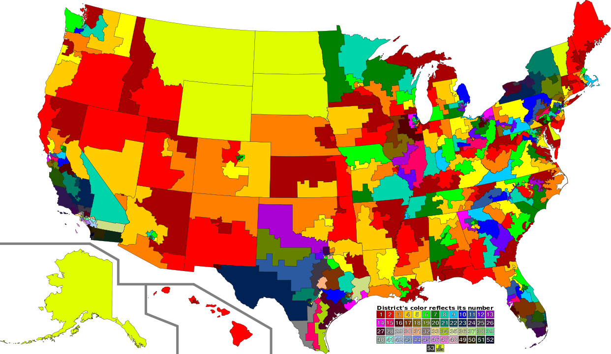
English: A map of all of the U.S. congressional districts (as of the 113th Congress). To find the district's number, look at the district, compare with the color code at the bottom to get number. The colors do not have any intrinsic meaning other than to provide visual distinction. |
| Datum | |
| Bron |
Dit bestand is afgeleid van: |
| Auteur |
|
| SVG ontwikkeling | De broncode van dit groot SVG-bestand is deugdelijk. |
Licentie
Dit bestand is gelicenseerd onder de Creative Commons-licentie Naamsvermelding 3.0 Unported
- De gebruiker mag:
- Delen – het werk kopiëren, verspreiden en doorgeven
- Remixen – afgeleide werken maken
- Onder de volgende voorwaarden:
- naamsvermelding – U moet op een gepaste manier aan naamsvermelding doen, een link naar de licentie geven, en aangeven of er wijzigingen in het werk zijn aangebracht. U mag dit op elke redelijke manier doen, maar niet zodanig dat de indruk wordt gewekt dat de licentiegever instemt met uw werk of uw gebruik van zijn werk.
Oorspronkelijk uploadlogboek
This image is a derivative work of the following images:
- File:US Congressional Districts color.svg licensed with PD-self
- 2009-09-14T22:28:34Z Mr. Matté 2583x1557 (1299871 Bytes) Fix western CA districts
- 2009-07-17T15:45:17Z Mr. Matté 2583x1557 (1280927 Bytes) Fix NY 26/27, make one path --> text
- 2008-08-21T02:52:58Z Mr. Matté 2583x1557 (1306679 Bytes) Fix Hawaii
- 2008-04-16T02:38:02Z Mr. Matté 2583x1557 (1366638 Bytes) Higher-quality, smaller version of the colored congressional map by district number
- 2008-02-06T23:06:44Z Mr. Matté 9111x5493 (1961159 Bytes) {{Information |Description=A map of all of the [[:en:List of United States congressional districts|U.S. congressional districts]] (as of the [[:en:110th United States Congress|110th Congress]]). To find the district's number
- File:113th U.S. Congress House districts blank.svg licensed with Cc-zero
Uploaded with derivativeFX
Bestandsgeschiedenis
Klik op een datum/tijd om het bestand te zien zoals het destijds was.
| Datum/tijd | Miniatuur | Afmetingen | Gebruiker | Opmerking | |
|---|---|---|---|---|---|
| huidige versie | 31 aug 2012 05:02 | | 1.242 × 721 (3,9 MB) | Magog the Ogre | GA 02/08 accidentally transposed |
| 31 aug 2012 03:47 |  | 1.242 × 721 (3,9 MB) | Magog the Ogre | {{Information |Description={{en|1=A map of all of the U.S. congressional districts (as of the 113th Congress). To find the district's number, look at the distric... |
Bestandsgebruik
Dit bestand wordt op de volgende pagina gebruikt:
Globaal bestandsgebruik
De volgende andere wiki's gebruiken dit bestand:
- Gebruikt op de.wikipedia.org
- Gebruikt op fa.wikipedia.org
- Gebruikt op fr.wikipedia.org
- Gebruikt op sv.wikipedia.org