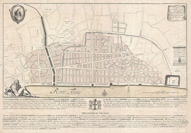
Bestand:1744 Wren Map of London, England - Geographicus - London-wren-1744.jpg

Pagina-inhoud wordt niet ondersteund in andere talen.
Uit Wikipedia, de vrije encyclopedie

Oorspronkelijk bestand(5.000 × 3.496 pixels, bestandsgrootte: 4,43 MB, MIME-type: image/jpeg)


Christopher Wren: Ichnographia urbis Londinii… (A Plan of the City of London, after the great FIRE, in the Year of Our Lord 1666.)   (Wikidata search (Cirrus search) Wikidata query (SPARQL)  Create new Wikidata item based on this file)
Kunstenaar
Christopher Wren  (1632–1723)  wikidata:Q170373 s:en:Author:Christopher Michael Wren q:en:Christopher Wren
 
Christopher Wren
Aliassen
Sir Christopher Wren
Beschrijving Brits architect, astronoom, wiskundige, natuurkundige, anatoom en academisch docent
Geboorte- en sterfdatum 20 oktober 1632 (volgens de Juliaanse kalenderBewerk dit op Wikidata 25 februari 1723 (volgens de Juliaanse kalenderBewerk dit op Wikidata
Geboorte- en sterfplaats East Knoyle Londen
Actieve periode 1657-1710
Werklocatie
Bibliografische informatie
artist QS:P170,Q170373
Titel
Ichnographia urbis Londinii… (A Plan of the City of London, after the great FIRE, in the Year of Our Lord 1666.)
Beschrijving
English: An extremely scarce 1744 map of London showing Sir Christopher Wren's plan for reconstructing the city following the 1666 Great Fire of London. In 1666 the Great Fire swept through the old Roman portions of London, laying waste to most of the original walled city. Christopher Wren, a well known architect of the period was quick to respond to the disaster as a opportunity to dramatically redesign and modernize London's center. Wren having been schooled in Paris envisioned an elaborate classically influenced reconstruction of the city with broad avenues meeting in a series of Piazzas. Despite, or perhaps because of, Wren's promptitude in producing a plan for a major post-fire reconstruction, his plan exhibits a number of dramatic errors. Wren did not take the city's topography into account and consequently much of the this plan is unfeasible. Despite claims to the contrary in the document itself, Wren's plan was never seriously considered by either the King or the Parliament. Today Wren's original 1666 plan is lost. This version was drawn in 1744 by the once fashionable engrave P. Fourdrinier, who claims to have replicated exactly a scarce 1724 original owned by the Earl of Pembroke. This map covers London along the north side of the Thames River from Strand Bridge to Great Tower Hill. Shows Wren's detailed reconstruction plan, along with the regions originally destroyed by the Great Fire. Identifies the proposed locations of parochial churches, markets, piazzas, bridges and warehouses. A vignette in the lower left quadrant depicts Thamesis, the river god for which the Thames River is named. The upper left quadrant bears the image of a phoenix, suggesting that, like the mythical bird, London too would rise from its own ashes and be reborn in fire. The lower quadrants of this plate include the map's title in both English and Latin as well as a detailed Explanation of the Plan. This plan is highly uncommon and rarely appears outside of institutional collections.
Datum 1744 (dated)
Afmetingen hoogte: 19 in (48,2 cm); breedte: 27,5 in (69,8 cm)
dimensions QS:P2048,19U218593
dimensions QS:P2049,27.5U218593
Inventarisnummer
Geographicus link: London-wren-1744
Bron/fotograaf
Toestemming
(Hergebruik van dit bestand)
Het tweedimensionale kunstwerk afgebeeld op deze afbeelding valt in het publiek domein omdat:
Public domain

Dit werk bevindt zich in het publiek domein in landen en gebieden waar de auteursrechttermijn het leven van de auteur plus 100 jaar of minder is.


Je dient ook een Amerikaans publiek domein-tag in te voegen om aan te geven waarom dit werk zich in het publiek domein bevindt in de Verenigde Staten.
Reproducties van het werk kunnen ook worden beschouwd als publiek domein omdat ze geen oorspronkelijk karakter hebben. Dit geldt voor reproducties gemaakt in de Verenigde Staten (zie Bridgeman Art Library v. Corel Corp.), Duitsland en veel andere landen.
Public domain
Dit werk bevindt zich in het publiek domein in de Verenigde Staten omdat het gepubliceerd werd (of geregistreerd bij de U.S. Copyright Office) voor 1 januari 1929.

Werken in het publiek domein moeten zowel vrij van auteursrechten zijn in de Verenigde Staten als in het land van herkomst van het werk om te worden gehost op Commons. Indien het werk geen Amerikaans werk is, moet het bestand een aanvullende copyright tag hebben met de auteursrechtelijke status in het land van herkomst.

Bijschriften

Beschrijf in één regel wat dit bestand voorstelt

Items getoond in dit bestand

beeldt af

image/jpeg

aac4573c33ddccb69d1cadc3765e753878fd91b4

4.649.137 byte

3.496 pixel

5.000 pixel

Bestandsgeschiedenis

Klik op een datum/tijd om het bestand te zien zoals het destijds was.

Datum/tijdMiniatuurAfmetingenGebruikerOpmerking
huidige versie23 mrt 2011 22:42Miniatuurafbeelding voor de versie van 23 mrt 2011 22:425.000 × 3.496 (4,43 MB)BotMultichillT{{subst:User:Multichill/Geographicus |link=http://www.geographicus.com/P/AntiqueMap/London-wren-1744 |product_name=1744 Wren Map of London, England |map_title=Ichnographia urbis Londinii… (A Plan of the City of London, after the great FIRE, in the Year

Dit bestand wordt op de volgende pagina gebruikt:

Globaal bestandsgebruik

De volgende andere wiki's gebruiken dit bestand: