
Bestand:1906 Boatwright intensity.jpg

Grootte van deze voorvertoning: 415 × 599 pixels. Andere resoluties: 166 × 240 pixels | 612 × 884 pixels.
Oorspronkelijk bestand (612 × 884 pixels, bestandsgrootte: 539 kB, MIME-type: image/jpeg)
| Dit is een bestand van Wikimedia Commons. Onderstaande beschrijving komt van de beschrijving van het bestand daar. |
Beschrijving
Public Domain
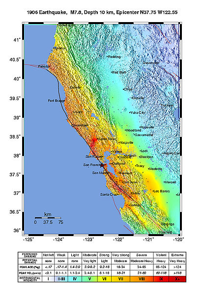
Intensity map for the 1906 San Francisco Earthquake deduced from the Lawson report
from U.S. Geological Survey Open-File Report 2005-1135
Modified Mercalli Intensity Maps for the 1906 San Francisco Earthquake Plotted in ShakeMap Format
By John Boatwright and Howard Bundock
Licentie
Deze afbeelding bevindt zich in het publiek domein omdat het materiaal bevat dat oorspronkelijk afkomstig is van de United States Geological Survey, een agentschap van de United States Department of the Interior. Voor meer informatie, zie het officiële USGS-auteursrechtenbeleid
|
Bestandsgeschiedenis
Klik op een datum/tijd om het bestand te zien zoals het destijds was.
| Datum/tijd | Miniatuur | Afmetingen | Gebruiker | Opmerking | |
|---|---|---|---|---|---|
| huidige versie | 30 mei 2006 23:45 | | 612 × 884 (539 kB) | Andre315 | Public Domain<br/> Intensity map for the 1906 San Francisco Earthquake deduced from the Lawson report<br/> from U.S. Geological Survey Open-File Report 2005-1135<br/> Modified Mercalli Intensity Maps for the 1906 San Francisco Earthquake Plotted in ShakeM |
Bestandsgebruik
Dit bestand wordt op de volgende pagina gebruikt:
Globaal bestandsgebruik
De volgende andere wiki's gebruiken dit bestand:
- Gebruikt op cs.wikipedia.org
- Gebruikt op de.wikipedia.org
- Gebruikt op en.wikipedia.org
- Gebruikt op fr.wikipedia.org
- Gebruikt op gl.wikipedia.org
- Gebruikt op hu.wikipedia.org
- Gebruikt op ka.wikipedia.org
- Gebruikt op ko.wikipedia.org
- Gebruikt op ms.wikipedia.org
- Gebruikt op tr.wikipedia.org