
Bestand:2002 Pacific typhoon season summary.jpg

Grootte van deze voorvertoning: 800 × 579 pixels. Andere resoluties: 320 × 232 pixels | 640 × 464 pixels | 1.024 × 742 pixels | 1.280 × 927 pixels | 2.560 × 1.854 pixels | 3.000 × 2.173 pixels.
Oorspronkelijk bestand (3.000 × 2.173 pixels, bestandsgrootte: 590 kB, MIME-type: image/jpeg)
| Dit is een bestand van Wikimedia Commons. Onderstaande beschrijving komt van de beschrijving van het bestand daar. |
| Beschrijving |
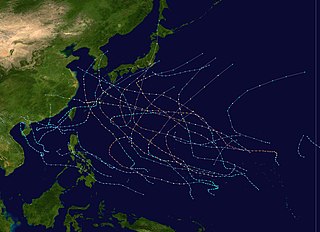
English: This map shows the tracks of all tropical cyclones in the 2002 Pacific typhoon season. The points show the location of each storm at 6-hour intervals. The colour represents the storm's maximum sustained wind speeds as classified in the Saffir-Simpson Hurricane Scale (see below), and the shape of the data points represent the type of the storm.
Tropical depression (≤38 mph, ≤62 km/h)
Tropical storm (39–73 mph, 63–118 km/h)
Category 1 (74–95 mph, 119–153 km/h)
Category 2 (96–110 mph, 154–177 km/h)
Category 3 (111–129 mph, 178–208 km/h)
Category 4 (130–156 mph, 209–251 km/h)
Category 5 (≥157 mph, ≥252 km/h)
Unknown
Storm type |
| Bron | Created using Wikipedia:WikiProject Tropical cyclones/Tracks. The background image is from NASA [1]. The tracking data is from the Joint Typhoon Warning Center's best track database |
| Auteur | Nilfanion |

|
Dit bestand kan geactualiseerd worden om nieuwe informatie te weerspiegelen. Indien je een specifieke versie van het bestand wil gebruiken zonder dat er nieuwe updates plaatsvinden, dien je die betrokken versie te uploaden als een afzonderlijk bestand. |
| Dit werk vrijgegeven in het publieke domein door de auteur, Nilfanion. Dit is wereldwijd van toepassing. In sommige landen is dit wettelijk niet mogelijk; in die gevallen geldt: Nilfanion staat iedereen toe dit werk voor eender welk doel te gebruiken, zonder enige voorwaarden, tenzij zulke voorwaarden door de wet worden voorgeschreven. |
Bestandsgeschiedenis
Klik op een datum/tijd om het bestand te zien zoals het destijds was.
| Datum/tijd | Miniatuur | Afmetingen | Gebruiker | Opmerking | |
|---|---|---|---|---|---|
| huidige versie | 3 aug 2007 00:24 | | 3.000 × 2.173 (590 kB) | NilfaBot | {{Information |Description=This map shows the tracks of all tropical cyclones in the w:2002 Pacific typhoon season. {{PD-user|Nilfanion}} |Source= |Date= |Author= |Permission= |other_versions= }} [[Category:Pacific typhoon |
Bestandsgebruik
Geen enkele pagina gebruikt dit bestand.
Globaal bestandsgebruik
De volgende andere wiki's gebruiken dit bestand:
- Gebruikt op en.wikipedia.org
- Gebruikt op pt.wikipedia.org
- Gebruikt op th.wikipedia.org
- Gebruikt op vi.wikipedia.org
- Gebruikt op zh.wikipedia.org
- 2002年太平洋颱風季
- 熱帶風暴黃蜂 (2002年)
- 熱帶風暴黑格比 (2002年)
- 颱風鳳仙
- 颱風風神 (2002年)
- WikiProject:太平洋颱風季/條目/典範條目
- 颱風查特安
- 颱風鹿莎
- Template:2002年太平洋颱風季
- 颱風米娜 (2002年)
- Wikipedia:优良条目/2015年5月
- Wikipedia:典范条目/2015年4月
- Talk:2002年太平洋颱風季
- Wikipedia:优良条目/2015年5月25日
- Wikipedia:优良条目/2002年太平洋台风季
- Wikipedia:典范条目/2002年太平洋台风季
- Wikipedia:典范条目/2015年4月24日
- Portal:美国/特色条目/267
- Wikipedia:典范条目/2017年6月
- Wikipedia:典范条目/2017年6月9日
- 颱風海高斯 (2002年)
- User:MCC214/2002年太平洋颱風季
- 颱風雷馬遜 (2002年)
- 強烈熱帶風暴北冕 (2002年)
- 2002年颱風辛樂克
- Wikipedia:典范条目/2020年1月
- Wikipedia:典范条目/2020年1月8日
- User:Michael Chan/沙盒
- 颱風夏浪 (2002年)